|
|
|||||||||||||||||
| Point ID: 800 | Downloads | Plots | Site Data | Code: 07KA002 |
|
|
|||||||||||||||||
| Download | |
|---|---|
| Site Descriptor Information | Site Time Series Data |
| Link to all available data | |
|
|
| View: | Statistics | Time Series |
| Units: | m3/s |
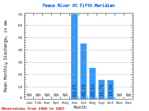
| Statistic | Jan | Feb | Mar | Apr | May | Jun | Jul | Aug | Sep | Oct | Nov | Dec | Annual |
|---|---|---|---|---|---|---|---|---|---|---|---|---|---|
| Mean | 69.25 | 45.25 | 25.49 | 15.75 | 15.36 | ||||||||
| Standard Deviation | 10.62 | 12.29 | 14.06 | 4.28 | 3.97 | ||||||||
| Min | 60.20 | 27.45 | 11.30 | 10.20 | 13.01 | ||||||||
| Max | 82.54 | 57.26 | 54.03 | 19.95 | 21.27 | ||||||||
| Coefficient of Variation | 0.15 | 0.27 | 0.55 | 0.27 | 0.26 |
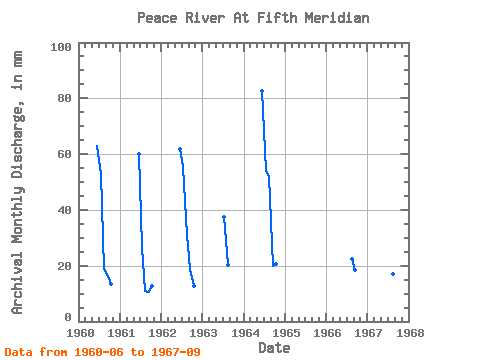
| Year | Jan | Feb | Mar | Apr | May | Jun | Jul | Aug | Sep | Oct | Nov | Dec | Annual | 1960 | 62.87 | 54.51 | 19.47 | 16.36 | 14.05 | 1961 | 60.20 | 27.45 | 11.30 | 10.66 | 13.11 | 1962 | 61.67 | 57.26 | 32.10 | 18.84 | 13.01 | 1963 | 38.75 | 20.80 | 1964 | 82.54 | 55.74 | 54.03 | 19.95 | 21.27 | 1966 | 23.17 | 18.48 | 1967 | 78.95 | 37.80 | 17.57 | 10.20 |
|---|
 Return to R-Arctic Net Home Page