|
|
|||||||||||||||||
| Point ID: 7999 | Downloads | Plots | Site Data | Code: 3661 |
|
|
|||||||||||||||||
| Download | |
|---|---|
| Site Descriptor Information | Site Time Series Data |
| Link to all available data | |
|
|
| View: | Statistics | Time Series |
| Units: | m3/s |
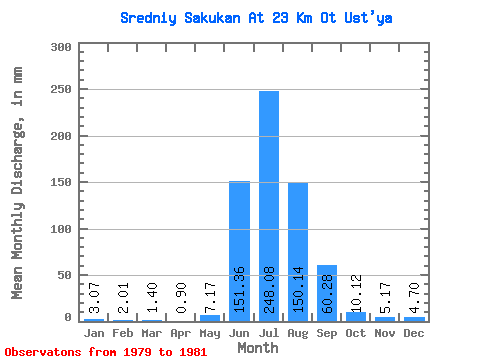
| Statistic | Jan | Feb | Mar | Apr | May | Jun | Jul | Aug | Sep | Oct | Nov | Dec | Annual |
|---|---|---|---|---|---|---|---|---|---|---|---|---|---|
| Mean | 3.07 | 2.03 | 1.40 | 0.90 | 7.17 | 151.37 | 248.04 | 150.12 | 60.28 | 10.12 | 5.18 | 4.70 | 640.11 |
| Standard Deviation | 1.71 | 1.39 | 1.05 | 0.41 | 10.81 | 5.51 | 90.52 | 56.12 | 18.26 | 1.96 | 0.89 | 0.45 | 88.27 |
| Min | 1.23 | 0.79 | 0.51 | 0.43 | 0.34 | 146.42 | 144.12 | 89.54 | 42.24 | 8.79 | 4.16 | 4.19 | 572.77 |
| Max | 4.60 | 3.54 | 2.56 | 1.19 | 19.62 | 157.30 | 309.71 | 200.34 | 78.75 | 12.37 | 5.74 | 5.01 | 740.04 |
| Coefficient of Variation | 0.56 | 0.69 | 0.75 | 0.45 | 1.51 | 0.04 | 0.36 | 0.37 | 0.30 | 0.19 | 0.17 | 0.10 | 0.14 |
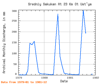
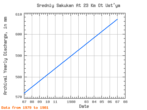
| Year | Jan | Feb | Mar | Apr | May | Jun | Jul | Aug | Sep | Oct | Nov | Dec | Annual | 1979 | 1.23 | 0.79 | 0.51 | 0.43 | 19.62 | 146.42 | 144.12 | 160.48 | 78.75 | 12.37 | 5.74 | 5.01 | 572.77 | 1980 | 4.60 | 3.54 | 2.56 | 1.19 | 1.53 | 157.30 | 290.29 | 89.54 | 42.24 | 8.79 | 5.64 | 4.19 | 607.51 | 1981 | 3.37 | 1.77 | 1.12 | 1.09 | 0.34 | 150.38 | 309.71 | 200.34 | 59.85 | 9.20 | 4.16 | 4.91 | 740.04 |
|---|
 Return to R-Arctic Net Home Page