|
|
|||||||||||||||||
| Point ID: 7976 | Downloads | Plots | Site Data | Code: 3618 |
|
|
|||||||||||||||||
| Download | |
|---|---|
| Site Descriptor Information | Site Time Series Data |
| Link to all available data | |
|
|
| View: | Statistics | Time Series |
| Units: | m3/s |
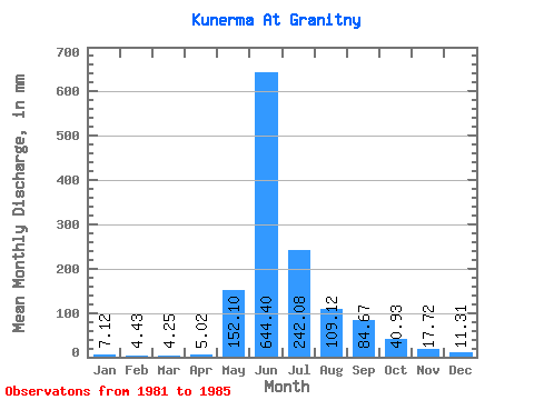
| Statistic | Jan | Feb | Mar | Apr | May | Jun | Jul | Aug | Sep | Oct | Nov | Dec | Annual |
|---|---|---|---|---|---|---|---|---|---|---|---|---|---|
| Mean | 7.12 | 4.47 | 4.25 | 5.02 | 152.07 | 644.40 | 242.04 | 109.11 | 84.67 | 40.93 | 17.73 | 11.31 | 1324.32 |
| Standard Deviation | 1.74 | 1.21 | 0.82 | 2.18 | 101.56 | 273.11 | 115.41 | 47.21 | 39.44 | 17.59 | 4.35 | 2.01 | 412.46 |
| Min | 4.69 | 2.76 | 3.31 | 3.47 | 51.30 | 304.31 | 136.80 | 52.95 | 29.36 | 19.31 | 13.35 | 8.27 | 905.47 |
| Max | 8.83 | 5.78 | 5.52 | 8.81 | 264.49 | 1030.39 | 424.73 | 153.07 | 137.74 | 68.40 | 22.42 | 13.79 | 1906.55 |
| Coefficient of Variation | 0.24 | 0.27 | 0.19 | 0.43 | 0.67 | 0.42 | 0.48 | 0.43 | 0.47 | 0.43 | 0.24 | 0.18 | 0.31 |
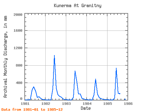
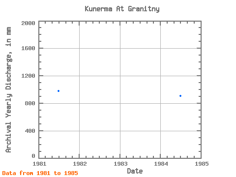
| Year | Jan | Feb | Mar | Apr | May | Jun | Jul | Aug | Sep | Oct | Nov | Dec | Annual | 1981 | 4.69 | 2.76 | 3.31 | 8.81 | 251.80 | 304.31 | 207.40 | 63.98 | 74.74 | 38.06 | 13.35 | 8.27 | 977.24 | 1982 | 6.07 | 3.77 | 3.86 | 4.27 | 264.49 | 1030.39 | 278.56 | 129.07 | 81.42 | 68.40 | 21.62 | 11.31 | 1906.55 | 1983 | 7.45 | 5.28 | 4.14 | 3.74 | 62.33 | 667.35 | 424.73 | 146.45 | 137.74 | 40.54 | 22.42 | 13.79 | 1536.02 | 1984 | 8.83 | 5.78 | 5.52 | 3.47 | 130.45 | 485.83 | 136.80 | 52.95 | 29.36 | 19.31 | 13.35 | 12.13 | 905.47 | 1985 | 8.55 | 4.77 | 4.41 | 4.80 | 51.30 | 734.09 | 162.72 | 153.07 | 100.10 | 38.34 | 17.89 | 11.03 | 1296.31 |
|---|
 Return to R-Arctic Net Home Page