|
|
|||||||||||||||||
| Point ID: 7965 | Downloads | Plots | Site Data | Code: 3605 |
|
|
|||||||||||||||||
| Download | |
|---|---|
| Site Descriptor Information | Site Time Series Data |
| Link to all available data | |
|
|
| View: | Statistics | Time Series |
| Units: | m3/s |
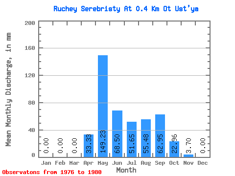
| Statistic | Jan | Feb | Mar | Apr | May | Jun | Jul | Aug | Sep | Oct | Nov | Dec | Annual |
|---|---|---|---|---|---|---|---|---|---|---|---|---|---|
| Mean | 0.00 | 0.00 | 0.00 | 33.33 | 149.59 | 68.50 | 50.88 | 55.85 | 63.69 | 23.72 | 3.70 | 0.00 | 446.72 |
| Standard Deviation | 0.00 | 0.00 | 0.00 | 43.75 | 44.93 | 25.75 | 28.16 | 31.21 | 17.74 | 9.13 | 3.70 | 0.00 | 66.12 |
| Min | 0.00 | 0.00 | 0.00 | 0.00 | 101.38 | 33.33 | 17.22 | 17.22 | 44.43 | 11.48 | 0.00 | 0.00 | 349.41 |
| Max | 0.00 | 0.00 | 0.00 | 105.53 | 210.41 | 101.83 | 82.25 | 82.25 | 87.02 | 34.43 | 9.26 | 0.00 | 522.24 |
| Coefficient of Variation | 1.31 | 0.30 | 0.38 | 0.55 | 0.56 | 0.28 | 0.39 | 1.00 | 0.15 |
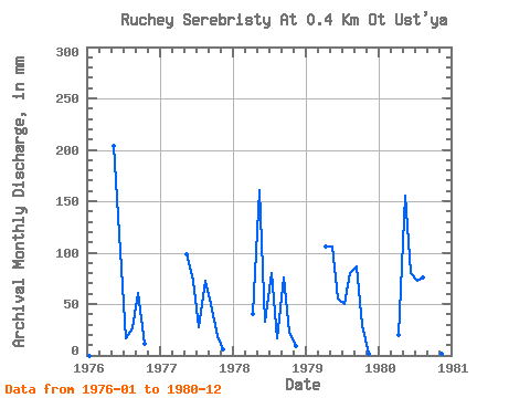
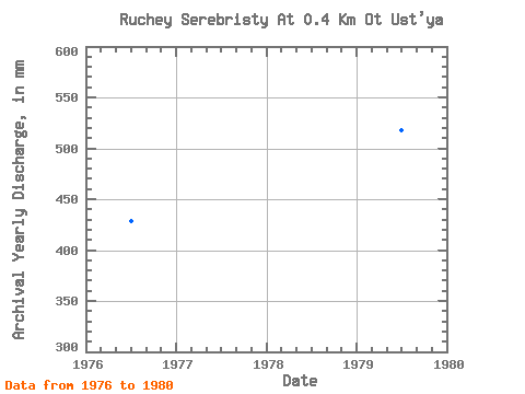
| Year | Jan | Feb | Mar | Apr | May | Jun | Jul | Aug | Sep | Oct | Nov | Dec | Annual | 1976 | 0.00 | 0.00 | 0.00 | 0.00 | 210.41 | 101.83 | 17.22 | 26.78 | 61.10 | 11.48 | 0.00 | 0.00 | 426.44 | 1977 | 0.00 | 0.00 | 0.00 | 0.00 | 101.38 | 72.21 | 28.69 | 74.60 | 49.99 | 19.13 | 5.55 | 0.00 | 349.41 | 1978 | 0.00 | 0.00 | 0.00 | 40.73 | 166.42 | 33.33 | 82.25 | 17.22 | 75.91 | 22.95 | 9.26 | 0.00 | 445.22 | 1979 | 0.00 | 0.00 | 0.00 | 105.53 | 109.03 | 55.54 | 51.65 | 82.25 | 87.02 | 30.61 | 1.85 | 0.00 | 522.24 | 1980 | 0.00 | 0.00 | 0.00 | 20.37 | 160.68 | 79.61 | 74.60 | 78.43 | 44.43 | 34.43 | 1.85 | 0.00 | 490.31 |
|---|
 Return to R-Arctic Net Home Page