|
|
|||||||||||||||||
| Point ID: 7964 | Downloads | Plots | Site Data | Code: 3604 |
|
|
|||||||||||||||||
| Download | |
|---|---|
| Site Descriptor Information | Site Time Series Data |
| Link to all available data | |

|
|
| View: | Statistics | Time Series |
| Units: | m3/s |
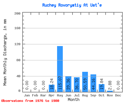
| Statistic | Jan | Feb | Mar | Apr | May | Jun | Jul | Aug | Sep | Oct | Nov | Dec | Annual |
|---|---|---|---|---|---|---|---|---|---|---|---|---|---|
| Mean | 0.00 | 0.00 | 0.00 | 18.43 | 115.06 | 39.36 | 36.50 | 50.98 | 44.35 | 19.44 | 3.07 | 0.00 | 324.76 |
| Standard Deviation | 0.00 | 0.00 | 0.00 | 24.84 | 28.57 | 14.51 | 19.83 | 30.99 | 18.45 | 10.65 | 2.75 | 0.00 | 67.59 |
| Min | 0.00 | 0.00 | 0.00 | 0.00 | 89.27 | 23.04 | 6.94 | 13.89 | 29.76 | 7.94 | 0.00 | 0.00 | 217.22 |
| Max | 0.00 | 0.00 | 0.00 | 59.52 | 158.70 | 54.72 | 55.54 | 78.36 | 75.84 | 36.70 | 6.72 | 0.00 | 384.76 |
| Coefficient of Variation | 1.35 | 0.25 | 0.37 | 0.54 | 0.61 | 0.42 | 0.55 | 0.90 | 0.21 |
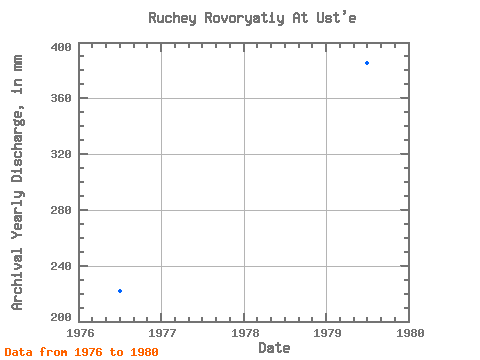
| Year | Jan | Feb | Mar | Apr | May | Jun | Jul | Aug | Sep | Oct | Nov | Dec | Annual | 1976 | 0.00 | 0.00 | 0.00 | 0.00 | 99.19 | 54.72 | 6.94 | 13.89 | 35.52 | 7.94 | 0.00 | 0.00 | 217.22 | 1977 | 0.00 | 0.00 | 0.00 | 1.92 | 99.19 | 41.28 | 29.76 | 73.40 | 45.12 | 17.85 | 2.88 | 0.00 | 308.78 | 1978 | 0.00 | 0.00 | 0.00 | 24.00 | 158.70 | 23.04 | 55.54 | 20.83 | 35.52 | 14.88 | 6.72 | 0.00 | 336.06 | 1979 | 0.00 | 0.00 | 0.00 | 59.52 | 89.27 | 25.92 | 36.70 | 78.36 | 75.84 | 19.84 | 0.96 | 0.00 | 384.76 | 1980 | 0.00 | 0.00 | 0.00 | 6.72 | 128.94 | 51.84 | 53.56 | 68.44 | 29.76 | 36.70 | 4.80 | 0.00 | 376.97 |
|---|
 Return to R-Arctic Net Home Page