|
|
|||||||||||||||||
| Point ID: 7941 | Downloads | Plots | Site Data | Code: 3570 |
|
|
|||||||||||||||||
| Download | |
|---|---|
| Site Descriptor Information | Site Time Series Data |
| Link to all available data | |
|
|
| View: | Statistics | Time Series |
| Units: | m3/s |
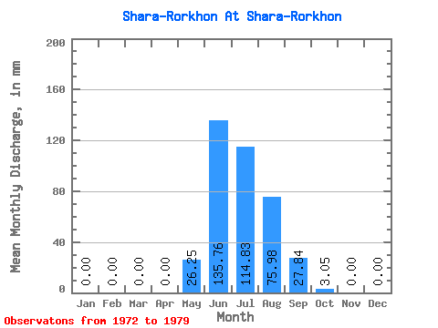
| Statistic | Jan | Feb | Mar | Apr | May | Jun | Jul | Aug | Sep | Oct | Nov | Dec | Annual |
|---|---|---|---|---|---|---|---|---|---|---|---|---|---|
| Mean | 0.00 | 0.00 | 0.00 | 0.00 | 26.28 | 135.76 | 114.84 | 75.91 | 27.87 | 3.05 | 0.00 | 0.00 | 401.27 |
| Standard Deviation | 0.00 | 0.00 | 0.00 | 0.00 | 46.16 | 241.37 | 212.68 | 151.16 | 47.02 | 5.21 | 0.00 | 0.00 | 725.28 |
| Min | 0.00 | 0.00 | 0.00 | 0.00 | 1.19 | 0.90 | 0.93 | 0.80 | 0.64 | 0.00 | 0.00 | 0.00 | 6.51 |
| Max | 0.00 | 0.00 | 0.00 | 0.00 | 95.45 | 496.59 | 433.52 | 346.02 | 111.64 | 12.33 | 0.00 | 0.00 | 1488.55 |
| Coefficient of Variation | 1.76 | 1.78 | 1.85 | 1.99 | 1.69 | 1.71 | 1.81 |
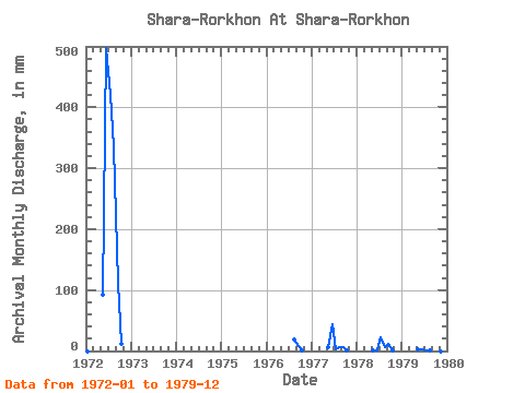
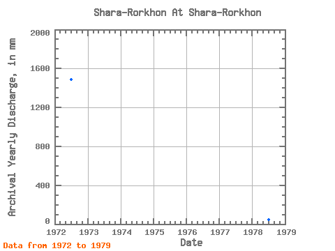
| Year | Jan | Feb | Mar | Apr | May | Jun | Jul | Aug | Sep | Oct | Nov | Dec | Annual | 1972 | 0.00 | 0.00 | 0.00 | 0.00 | 95.45 | 496.59 | 433.52 | 346.02 | 111.64 | 12.33 | 0.00 | 0.00 | 1488.55 | 1976 | 19.89 | 8.73 | 1.06 | 0.00 | 0.00 | 1977 | 0.00 | 0.00 | 0.00 | 0.00 | 6.23 | 43.63 | 2.39 | 7.16 | 5.90 | 0.93 | 0.00 | 0.00 | 66.66 | 1978 | 0.00 | 0.00 | 0.00 | 0.00 | 1.19 | 0.90 | 22.54 | 5.70 | 12.45 | 0.93 | 0.00 | 0.00 | 43.36 | 1979 | 0.00 | 0.00 | 0.00 | 0.00 | 2.25 | 1.93 | 0.93 | 0.80 | 0.64 | 0.00 | 0.00 | 0.00 | 6.51 |
|---|
 Return to R-Arctic Net Home Page