|
|
|||||||||||||||||
| Point ID: 7935 | Downloads | Plots | Site Data | Code: 3549 |
|
|
|||||||||||||||||
| Download | |
|---|---|
| Site Descriptor Information | Site Time Series Data |
| Link to all available data | |
|
|
| View: | Statistics | Time Series |
| Units: | m3/s |
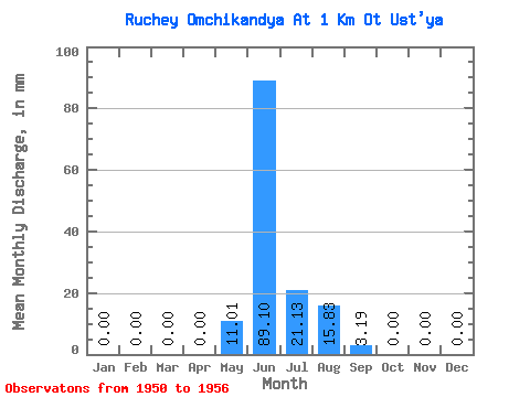
| Statistic | Jan | Feb | Mar | Apr | May | Jun | Jul | Aug | Sep | Oct | Nov | Dec | Annual |
|---|---|---|---|---|---|---|---|---|---|---|---|---|---|
| Mean | 0.00 | 0.00 | 0.00 | 0.00 | 11.02 | 89.12 | 21.15 | 15.82 | 3.18 | 0.00 | 0.00 | 0.00 | 140.78 |
| Standard Deviation | 0.00 | 0.00 | 0.00 | 0.00 | 24.79 | 29.21 | 20.34 | 13.28 | 2.38 | 0.00 | 0.00 | 0.00 | 56.11 |
| Min | 0.00 | 0.00 | 0.00 | 0.00 | 0.00 | 36.46 | 0.23 | 0.18 | 0.17 | 0.00 | 0.00 | 0.00 | 39.59 |
| Max | 0.00 | 0.00 | 0.00 | 0.00 | 66.51 | 132.16 | 53.56 | 32.96 | 6.84 | 0.00 | 0.00 | 0.00 | 200.00 |
| Coefficient of Variation | 2.25 | 0.33 | 0.96 | 0.84 | 0.75 | 0.40 |
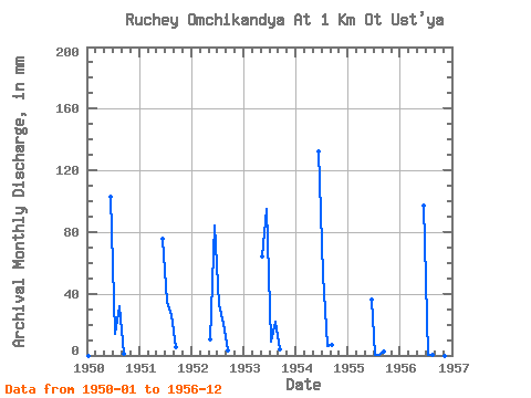
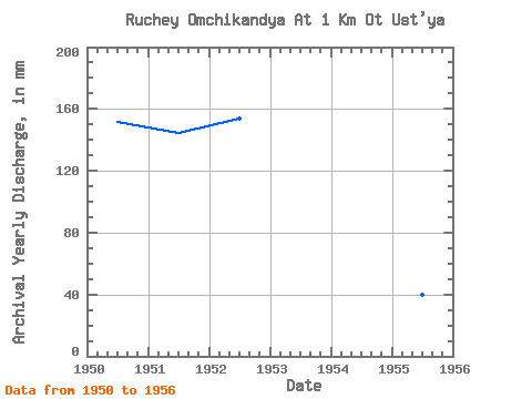
| Year | Jan | Feb | Mar | Apr | May | Jun | Jul | Aug | Sep | Oct | Nov | Dec | Annual | 1950 | 0.00 | 0.00 | 0.00 | 0.00 | 0.00 | 103.11 | 14.13 | 32.96 | 0.74 | 0.00 | 0.00 | 0.00 | 151.62 | 1951 | 0.00 | 0.00 | 0.00 | 0.00 | 0.00 | 75.77 | 35.90 | 27.07 | 5.24 | 0.00 | 0.00 | 0.00 | 144.04 | 1952 | 0.00 | 0.00 | 0.00 | 0.00 | 10.59 | 84.34 | 34.14 | 21.19 | 3.30 | 0.00 | 0.00 | 0.00 | 153.67 | 1953 | 0.00 | 0.00 | 0.00 | 0.00 | 66.51 | 95.14 | 9.42 | 22.37 | 3.82 | 0.00 | 0.00 | 0.00 | 196.93 | 1954 | 0.00 | 0.00 | 0.00 | 0.00 | 0.00 | 132.16 | 53.56 | 6.47 | 6.84 | 0.00 | 0.00 | 0.00 | 200.00 | 1955 | 0.00 | 0.00 | 0.00 | 0.00 | 0.00 | 36.46 | 0.23 | 0.18 | 2.17 | 0.00 | 0.00 | 0.00 | 39.59 | 1956 | 0.00 | 0.00 | 0.00 | 0.00 | 0.00 | 96.84 | 0.65 | 0.53 | 0.17 | 0.00 | 0.00 | 0.00 | 99.59 |
|---|
 Return to R-Arctic Net Home Page