|
|
|||||||||||||||||
| Point ID: 7897 | Downloads | Plots | Site Data | Code: 3387 |
|
|
|||||||||||||||||
| Download | |
|---|---|
| Site Descriptor Information | Site Time Series Data |
| Link to all available data | |
|
|
| View: | Statistics | Time Series |
| Units: | m3/s |
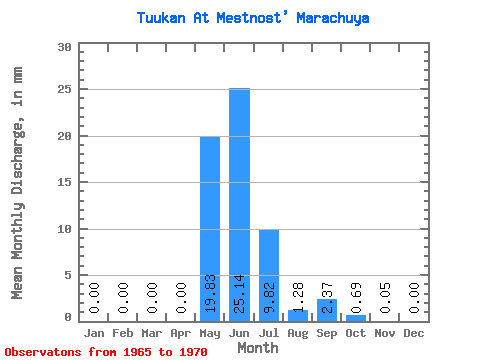
| Statistic | Jan | Feb | Mar | Apr | May | Jun | Jul | Aug | Sep | Oct | Nov | Dec | Annual |
|---|---|---|---|---|---|---|---|---|---|---|---|---|---|
| Mean | 0.00 | 0.00 | 0.00 | 0.00 | 19.83 | 25.14 | 9.82 | 1.27 | 2.37 | 0.69 | 0.05 | 0.00 | 57.68 |
| Standard Deviation | 0.00 | 0.00 | 0.00 | 0.00 | 17.27 | 13.25 | 12.28 | 1.54 | 2.17 | 0.89 | 0.09 | 0.00 | 33.56 |
| Min | 0.00 | 0.00 | 0.00 | 0.00 | 3.58 | 14.58 | 2.88 | 0.11 | 0.06 | 0.07 | 0.00 | 0.00 | 25.41 |
| Max | 0.00 | 0.00 | 0.00 | 0.01 | 50.56 | 46.75 | 34.54 | 3.90 | 5.09 | 1.98 | 0.19 | 0.00 | 104.80 |
| Coefficient of Variation | 2.45 | 0.87 | 0.53 | 1.25 | 1.21 | 0.92 | 1.28 | 1.73 | 2.00 | 0.58 |
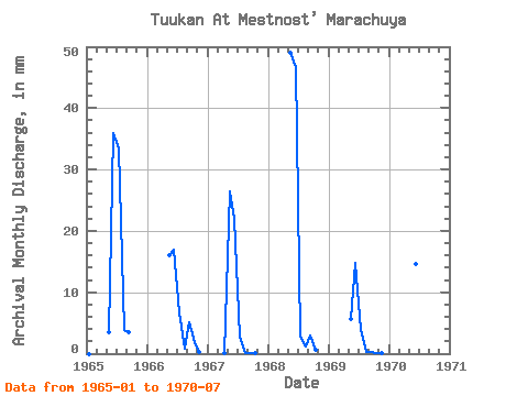
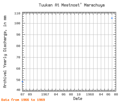
| Year | Jan | Feb | Mar | Apr | May | Jun | Jul | Aug | Sep | Oct | Nov | Dec | Annual | 1965 | 0.00 | 0.00 | 0.00 | 0.00 | 3.58 | 35.85 | 34.54 | 3.90 | 3.49 | 1966 | 0.00 | 0.00 | 0.00 | 0.00 | 16.62 | 16.98 | 6.93 | 0.79 | 5.09 | 1.98 | 0.19 | 0.00 | 48.44 | 1967 | 0.00 | 0.00 | 0.00 | 0.01 | 27.28 | 21.88 | 2.88 | 0.11 | 0.06 | 0.07 | 0.00 | 0.00 | 52.07 | 1968 | 0.00 | 0.00 | 0.00 | 0.00 | 50.56 | 46.75 | 2.95 | 1.26 | 2.96 | 0.59 | 0.00 | 0.00 | 104.80 | 1969 | 0.00 | 0.00 | 0.00 | 0.00 | 5.86 | 14.80 | 4.00 | 0.30 | 0.25 | 0.14 | 0.02 | 0.00 | 25.41 | 1970 | 0.00 | 0.00 | 0.00 | 0.00 | 15.09 | 14.58 | 7.61 |
|---|
 Return to R-Arctic Net Home Page