|
|
|||||||||||||||||
| Point ID: 7892 | Downloads | Plots | Site Data | Code: 3377 |
|
|
|||||||||||||||||
| Download | |
|---|---|
| Site Descriptor Information | Site Time Series Data |
| Link to all available data | |
|
|
| View: | Statistics | Time Series |
| Units: | m3/s |
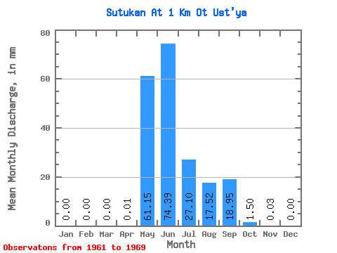
| Statistic | Jan | Feb | Mar | Apr | May | Jun | Jul | Aug | Sep | Oct | Nov | Dec | Annual |
|---|---|---|---|---|---|---|---|---|---|---|---|---|---|
| Mean | 0.00 | 0.00 | 0.00 | 0.01 | 61.14 | 74.39 | 27.09 | 17.52 | 18.95 | 1.49 | 0.03 | 0.00 | 200.07 |
| Standard Deviation | 0.00 | 0.00 | 0.00 | 0.03 | 26.59 | 21.18 | 22.97 | 27.38 | 10.14 | 1.14 | 0.06 | 0.00 | 58.62 |
| Min | 0.00 | 0.00 | 0.00 | 0.00 | 36.87 | 44.77 | 2.85 | 0.06 | 3.60 | 0.10 | 0.00 | 0.00 | 126.74 |
| Max | 0.00 | 0.00 | 0.00 | 0.07 | 104.69 | 103.34 | 63.30 | 66.08 | 28.78 | 2.61 | 0.13 | 0.00 | 285.50 |
| Coefficient of Variation | 2.24 | 0.43 | 0.28 | 0.85 | 1.56 | 0.54 | 0.76 | 2.24 | 0.29 |
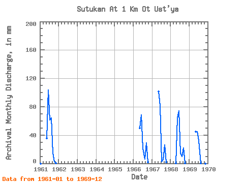
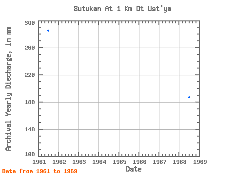
| Year | Jan | Feb | Mar | Apr | May | Jun | Jul | Aug | Sep | Oct | Nov | Dec | Annual | 1961 | 0.00 | 0.00 | 0.00 | 0.00 | 36.87 | 103.34 | 63.30 | 66.08 | 14.47 | 2.61 | 0.13 | 0.00 | 285.50 | 1966 | 0.00 | 0.00 | 0.00 | 0.00 | 51.47 | 68.67 | 22.05 | 6.05 | 28.78 | 2.12 | 0.00 | 0.00 | 179.11 | 1967 | 0.00 | 0.00 | 0.00 | 0.00 | 104.69 | 81.13 | 2.85 | 5.25 | 26.09 | 2.19 | 0.00 | 0.00 | 221.71 | 1968 | 0.00 | 0.00 | 0.00 | 0.07 | 66.43 | 74.06 | 14.61 | 10.16 | 21.78 | 0.45 | 0.00 | 0.00 | 187.31 | 1969 | 0.00 | 0.00 | 0.00 | 0.00 | 46.26 | 44.77 | 32.66 | 0.06 | 3.60 | 0.10 | 0.00 | 0.00 | 126.74 |
|---|
 Return to R-Arctic Net Home Page