|
|
|||||||||||||||||
| Point ID: 7875 | Downloads | Plots | Site Data | Code: 3346 |
|
|
|||||||||||||||||
| Download | |
|---|---|
| Site Descriptor Information | Site Time Series Data |
| Link to all available data | |
|
|
| View: | Statistics | Time Series |
| Units: | m3/s |
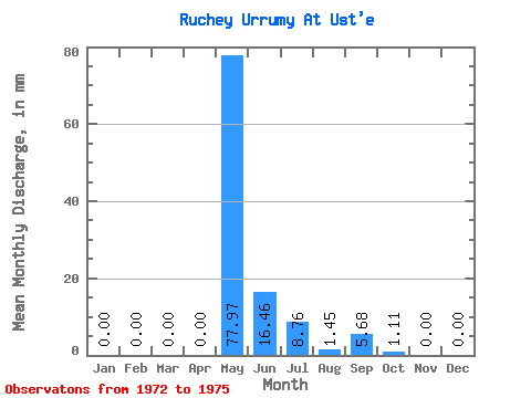
| Statistic | Jan | Feb | Mar | Apr | May | Jun | Jul | Aug | Sep | Oct | Nov | Dec | Annual |
|---|---|---|---|---|---|---|---|---|---|---|---|---|---|
| Mean | 0.00 | 0.00 | 0.00 | 0.00 | 78.00 | 16.46 | 8.71 | 1.41 | 5.69 | 1.10 | 0.00 | 0.00 | 118.80 |
| Standard Deviation | 0.00 | 0.00 | 0.00 | 0.00 | 23.77 | 13.98 | 12.03 | 1.97 | 6.76 | 1.72 | 0.00 | 0.00 | 20.54 |
| Min | 0.00 | 0.00 | 0.00 | 0.00 | 43.36 | 6.58 | 0.00 | 0.00 | 0.00 | 0.00 | 0.00 | 0.00 | 100.19 |
| Max | 0.00 | 0.00 | 0.00 | 0.00 | 96.92 | 37.03 | 25.50 | 3.66 | 13.17 | 3.62 | 0.00 | 0.00 | 140.83 |
| Coefficient of Variation | 0.30 | 0.85 | 1.38 | 1.40 | 1.19 | 1.57 | 0.17 |
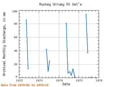
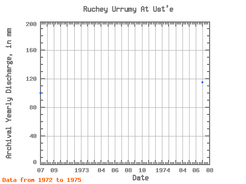
| Year | Jan | Feb | Mar | Apr | May | Jun | Jul | Aug | Sep | Oct | Nov | Dec | Annual | 1972 | 0.00 | 0.00 | 0.00 | 0.00 | 88.42 | 13.17 | 0.00 | 0.00 | 0.00 | 0.00 | 0.00 | 0.00 | 100.19 | 1973 | 0.00 | 0.00 | 0.00 | 0.00 | 43.36 | 9.05 | 25.50 | 0.00 | 0.00 | 0.00 | 1974 | 0.00 | 0.00 | 0.00 | 0.00 | 83.32 | 6.58 | 9.35 | 3.66 | 13.17 | 0.77 | 0.00 | 0.00 | 115.39 | 1975 | 0.00 | 0.00 | 0.00 | 0.00 | 96.92 | 37.03 | 0.00 | 0.56 | 3.92 | 3.62 | 0.00 | 0.00 | 140.83 |
|---|
 Return to R-Arctic Net Home Page