|
|
|||||||||||||||||
| Point ID: 7859 | Downloads | Plots | Site Data | Code: 3290 |
|
|
|||||||||||||||||
| Download | |
|---|---|
| Site Descriptor Information | Site Time Series Data |
| Link to all available data | |
|
|
| View: | Statistics | Time Series |
| Units: | m3/s |
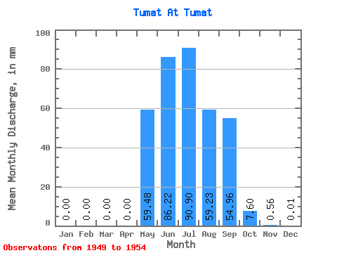
| Statistic | Jan | Feb | Mar | Apr | May | Jun | Jul | Aug | Sep | Oct | Nov | Dec | Annual |
|---|---|---|---|---|---|---|---|---|---|---|---|---|---|
| Mean | 0.00 | 0.00 | 0.00 | 0.00 | 59.47 | 86.22 | 90.89 | 59.23 | 54.95 | 7.61 | 0.57 | 0.02 | 370.57 |
| Standard Deviation | 0.00 | 0.00 | 0.00 | 0.00 | 20.29 | 60.17 | 53.98 | 28.95 | 42.57 | 5.13 | 0.29 | 0.04 | 135.81 |
| Min | 0.00 | 0.00 | 0.00 | 0.00 | 39.68 | 37.20 | 18.87 | 20.68 | 6.71 | 1.53 | 0.23 | 0.00 | 145.19 |
| Max | 0.00 | 0.00 | 0.00 | 0.00 | 89.08 | 154.45 | 167.90 | 85.47 | 107.04 | 16.65 | 1.02 | 0.10 | 507.37 |
| Coefficient of Variation | 0.34 | 0.70 | 0.59 | 0.49 | 0.78 | 0.67 | 0.51 | 2.10 | 0.37 |
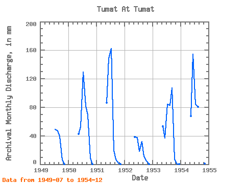
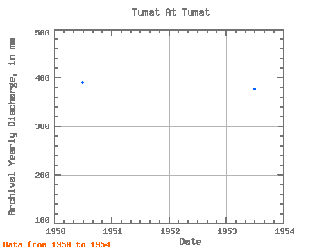
| Year | Jan | Feb | Mar | Apr | May | Jun | Jul | Aug | Sep | Oct | Nov | Dec | Annual | 1949 | 50.78 | 48.29 | 39.35 | 6.66 | 0.27 | 0.00 | 1950 | 0.00 | 0.00 | 0.00 | 0.00 | 43.71 | 52.51 | 133.48 | 84.50 | 69.30 | 9.16 | 0.63 | 0.00 | 390.24 | 1951 | 0.00 | 0.00 | 0.00 | 0.00 | 89.08 | 149.07 | 167.90 | 20.68 | 6.71 | 1.53 | 0.23 | 0.00 | 432.48 | 1952 | 0.00 | 0.00 | 0.00 | 0.00 | 39.68 | 37.87 | 18.87 | 33.16 | 11.42 | 4.58 | 0.60 | 0.00 | 145.19 | 1953 | 0.00 | 0.00 | 0.00 | 0.00 | 54.95 | 37.20 | 87.28 | 85.47 | 107.04 | 7.08 | 0.65 | 0.01 | 377.59 | 1954 | 0.00 | 0.00 | 0.00 | 0.00 | 69.93 | 154.45 | 87.00 | 83.25 | 95.89 | 16.65 | 1.02 | 0.10 | 507.37 |
|---|
 Return to R-Arctic Net Home Page