|
|
|||||||||||||||||
| Point ID: 7827 | Downloads | Plots | Site Data | Code: 3193 |
|
|
|||||||||||||||||
| Download | |
|---|---|
| Site Descriptor Information | Site Time Series Data |
| Link to all available data | |
|
|
| View: | Statistics | Time Series |
| Units: | m3/s |
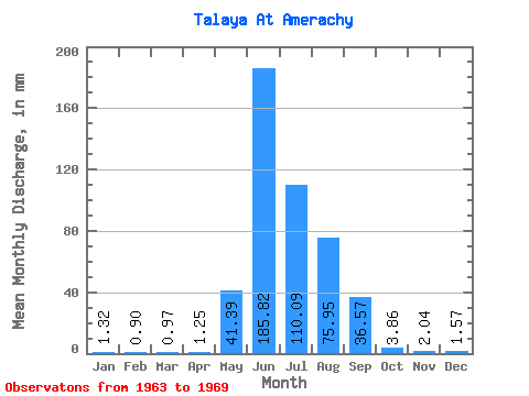
| Statistic | Jan | Feb | Mar | Apr | May | Jun | Jul | Aug | Sep | Oct | Nov | Dec | Annual |
|---|---|---|---|---|---|---|---|---|---|---|---|---|---|
| Mean | 1.31 | 0.90 | 0.97 | 1.25 | 41.39 | 185.82 | 110.08 | 75.94 | 36.58 | 3.85 | 2.04 | 1.57 | 460.96 |
| Standard Deviation | 0.24 | 0.16 | 0.22 | 0.49 | 37.91 | 69.96 | 34.85 | 52.88 | 19.26 | 0.71 | 0.33 | 0.19 | 122.76 |
| Min | 0.85 | 0.70 | 0.75 | 0.74 | 6.09 | 113.44 | 61.91 | 21.39 | 21.54 | 2.78 | 1.62 | 1.22 | 361.80 |
| Max | 1.60 | 1.12 | 1.41 | 2.19 | 101.90 | 314.74 | 159.81 | 162.77 | 71.87 | 4.87 | 2.36 | 1.74 | 701.22 |
| Coefficient of Variation | 0.18 | 0.18 | 0.23 | 0.39 | 0.92 | 0.38 | 0.32 | 0.70 | 0.53 | 0.18 | 0.16 | 0.12 | 0.27 |
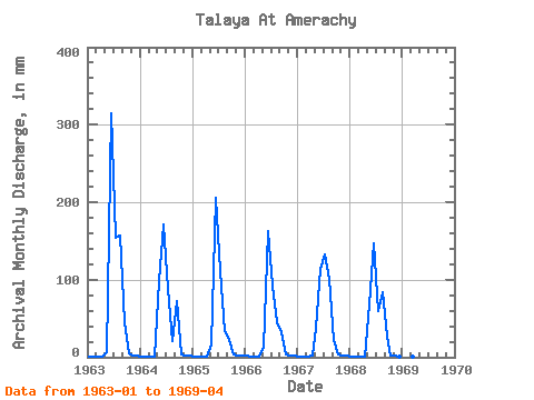
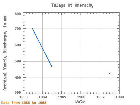
| Year | Jan | Feb | Mar | Apr | May | Jun | Jul | Aug | Sep | Oct | Nov | Dec | Annual | 1963 | 1.41 | 0.89 | 0.99 | 1.40 | 6.09 | 314.74 | 159.81 | 162.77 | 44.94 | 4.87 | 2.36 | 1.62 | 701.22 | 1964 | 1.25 | 0.70 | 0.75 | 0.86 | 101.90 | 171.68 | 91.47 | 21.39 | 71.87 | 3.65 | 2.19 | 1.74 | 469.13 | 1965 | 1.41 | 0.92 | 0.80 | 0.96 | 16.52 | 205.34 | 115.47 | 34.43 | 22.72 | 3.65 | 2.36 | 1.64 | 406.56 | 1966 | 1.60 | 1.09 | 1.41 | 0.74 | 13.22 | 162.25 | 95.47 | 46.78 | 31.64 | 3.83 | 2.02 | 1.72 | 361.80 | 1967 | 1.46 | 0.84 | 0.90 | 2.19 | 39.82 | 113.44 | 136.34 | 103.99 | 21.54 | 4.35 | 1.62 | 1.51 | 424.93 | 1968 | 1.22 | 1.12 | 0.89 | 1.41 | 70.78 | 147.44 | 61.91 | 86.25 | 26.76 | 2.78 | 1.68 | 1.22 | 402.12 | 1969 | 0.85 | 0.74 | 1.06 | 1.21 |
|---|
 Return to R-Arctic Net Home Page