|
|
|||||||||||||||||
| Point ID: 7823 | Downloads | Plots | Site Data | Code: 3184 |
|
|
|||||||||||||||||
| Download | |
|---|---|
| Site Descriptor Information | Site Time Series Data |
| Link to all available data | |
|
|
| View: | Statistics | Time Series |
| Units: | m3/s |
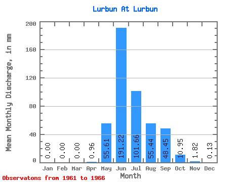
| Statistic | Jan | Feb | Mar | Apr | May | Jun | Jul | Aug | Sep | Oct | Nov | Dec | Annual |
|---|---|---|---|---|---|---|---|---|---|---|---|---|---|
| Mean | 0.00 | 0.00 | 0.00 | 0.96 | 55.60 | 191.22 | 101.64 | 55.43 | 48.45 | 10.95 | 1.82 | 0.14 | 465.76 |
| Standard Deviation | 0.01 | 0.00 | 0.00 | 0.51 | 25.65 | 43.20 | 35.25 | 35.21 | 18.25 | 2.91 | 1.33 | 0.28 | 56.12 |
| Min | 0.00 | 0.00 | 0.00 | 0.00 | 34.53 | 120.39 | 52.45 | 17.78 | 34.68 | 7.70 | 0.54 | 0.00 | 425.81 |
| Max | 0.02 | 0.00 | 0.00 | 1.35 | 102.57 | 240.33 | 149.45 | 113.25 | 84.00 | 15.13 | 3.50 | 0.70 | 574.59 |
| Coefficient of Variation | 2.45 | 0.53 | 0.46 | 0.23 | 0.35 | 0.64 | 0.38 | 0.27 | 0.73 | 2.06 | 0.12 |
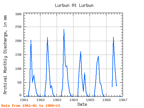
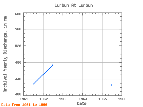
| Year | Jan | Feb | Mar | Apr | May | Jun | Jul | Aug | Sep | Oct | Nov | Dec | Annual | 1961 | 0.00 | 0.00 | 0.00 | 1.35 | 34.53 | 201.70 | 52.45 | 79.36 | 41.10 | 11.93 | 3.50 | 0.70 | 427.05 | 1962 | 0.02 | 0.00 | 0.00 | 1.30 | 64.98 | 211.58 | 119.28 | 30.21 | 37.73 | 7.70 | 1.12 | 0.00 | 473.65 | 1963 | 0.00 | 0.00 | 0.00 | 1.08 | 39.45 | 240.33 | 111.85 | 113.25 | 50.76 | 15.13 | 3.32 | 0.10 | 574.59 | 1964 | 0.00 | 0.00 | 0.00 | 0.81 | 102.57 | 160.82 | 69.16 | 17.78 | 84.00 | 13.04 | 1.89 | 0.01 | 450.08 | 1965 | 0.00 | 0.00 | 0.00 | 1.21 | 53.37 | 120.39 | 149.45 | 51.05 | 42.41 | 9.70 | 0.54 | 0.00 | 425.81 | 1966 | 0.00 | 0.00 | 0.00 | 0.00 | 38.71 | 212.48 | 107.68 | 40.94 | 34.68 | 8.21 | 0.54 | 0.00 | 443.36 |
|---|
 Return to R-Arctic Net Home Page