|
|
|||||||||||||||||
| Point ID: 7810 | Downloads | Plots | Site Data | Code: 3129 |
|
|
|||||||||||||||||
| Download | |
|---|---|
| Site Descriptor Information | Site Time Series Data |
| Link to all available data | |
|
|
| View: | Statistics | Time Series |
| Units: | m3/s |
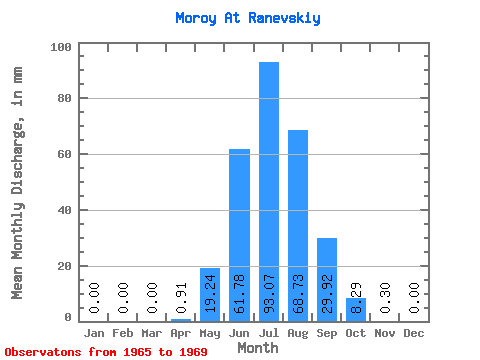
| Statistic | Jan | Feb | Mar | Apr | May | Jun | Jul | Aug | Sep | Oct | Nov | Dec | Annual |
|---|---|---|---|---|---|---|---|---|---|---|---|---|---|
| Mean | 0.00 | 0.00 | 0.00 | 0.91 | 19.23 | 61.78 | 93.06 | 68.72 | 29.93 | 8.29 | 0.30 | 0.00 | 280.20 |
| Standard Deviation | 0.00 | 0.00 | 0.00 | 1.21 | 11.68 | 47.14 | 98.39 | 38.52 | 11.57 | 6.03 | 0.17 | 0.00 | 141.08 |
| Min | 0.00 | 0.00 | 0.00 | 0.00 | 5.25 | 22.68 | 16.92 | 22.51 | 13.84 | 2.79 | 0.06 | 0.00 | 168.03 |
| Max | 0.00 | 0.00 | 0.00 | 2.83 | 33.89 | 134.31 | 212.38 | 125.65 | 41.77 | 15.48 | 0.49 | 0.00 | 462.39 |
| Coefficient of Variation | 1.32 | 0.61 | 0.76 | 1.06 | 0.56 | 0.39 | 0.73 | 0.56 | 0.50 |
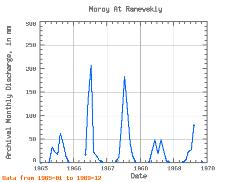
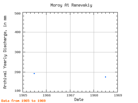
| Year | Jan | Feb | Mar | Apr | May | Jun | Jul | Aug | Sep | Oct | Nov | Dec | Annual | 1965 | 0.00 | 0.00 | 0.00 | 0.13 | 33.89 | 22.93 | 16.92 | 63.46 | 40.66 | 15.48 | 0.38 | 0.00 | 192.47 | 1966 | 0.00 | 0.00 | 0.00 | 0.00 | 16.88 | 134.31 | 212.38 | 22.51 | 13.84 | 5.50 | 0.06 | 0.00 | 403.04 | 1967 | 0.00 | 0.00 | 0.00 | 2.83 | 12.06 | 81.49 | 188.26 | 125.65 | 41.77 | 14.09 | 0.49 | 0.00 | 462.39 | 1968 | 0.00 | 0.00 | 0.00 | 1.39 | 28.09 | 47.50 | 19.08 | 49.92 | 26.57 | 2.79 | 0.38 | 0.00 | 175.06 | 1969 | 0.00 | 0.00 | 0.00 | 0.21 | 5.25 | 22.68 | 28.64 | 82.08 | 26.78 | 3.60 | 0.20 | 0.00 | 168.03 |
|---|
 Return to R-Arctic Net Home Page