|
|
|||||||||||||||||
| Point ID: 7788 | Downloads | Plots | Site Data | Code: 3058 |
|
|
|||||||||||||||||
| Download | |
|---|---|
| Site Descriptor Information | Site Time Series Data |
| Link to all available data | |

|
|
| View: | Statistics | Time Series |
| Units: | m3/s |
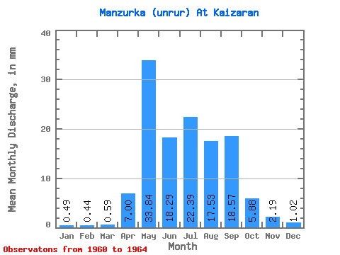
| Statistic | Jan | Feb | Mar | Apr | May | Jun | Jul | Aug | Sep | Oct | Nov | Dec | Annual |
|---|---|---|---|---|---|---|---|---|---|---|---|---|---|
| Mean | 0.49 | 0.44 | 0.59 | 7.00 | 33.83 | 18.29 | 22.39 | 17.53 | 18.57 | 5.88 | 2.19 | 1.02 | 135.61 |
| Standard Deviation | 0.38 | 0.39 | 0.54 | 5.60 | 13.03 | 9.02 | 16.16 | 10.16 | 18.49 | 2.56 | 1.39 | 0.63 | 29.19 |
| Min | 0.12 | 0.10 | 0.14 | 1.47 | 22.04 | 8.21 | 10.21 | 7.87 | 5.76 | 3.48 | 1.40 | 0.33 | 116.51 |
| Max | 1.02 | 0.99 | 1.38 | 14.50 | 52.14 | 29.59 | 46.21 | 26.54 | 45.88 | 9.50 | 4.27 | 1.80 | 169.20 |
| Coefficient of Variation | 0.77 | 0.88 | 0.92 | 0.80 | 0.39 | 0.49 | 0.72 | 0.58 | 1.00 | 0.43 | 0.63 | 0.61 | 0.21 |
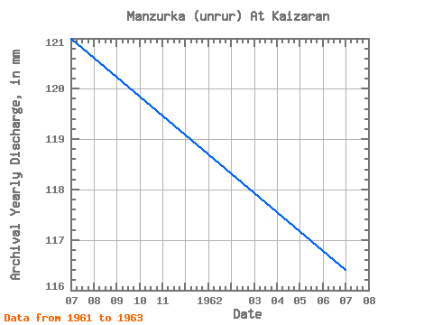
| Year | Jan | Feb | Mar | Apr | May | Jun | Jul | Aug | Sep | Oct | Nov | Dec | Annual | 1960 | 9.04 | 5.33 | 1.40 | 0.33 | 1961 | 0.12 | 0.10 | 0.14 | 14.50 | 22.04 | 20.32 | 16.42 | 26.54 | 13.60 | 5.19 | 1.47 | 1.21 | 121.11 | 1962 | 0.45 | 0.34 | 0.45 | 7.64 | 27.96 | 15.05 | 46.21 | 7.87 | 5.76 | 3.48 | 1.63 | 0.76 | 116.51 | 1963 | 0.38 | 0.32 | 0.40 | 1.47 | 33.18 | 29.59 | 16.71 | 26.07 | 45.88 | 9.50 | 4.27 | 1.80 | 169.20 | 1964 | 1.02 | 0.99 | 1.38 | 4.40 | 52.14 | 8.21 | 10.21 | 9.65 |
|---|
 Return to R-Arctic Net Home Page