|
|
|||||||||||||||||
| Point ID: 7782 | Downloads | Plots | Site Data | Code: 70617 |
|
|
|||||||||||||||||
| Download | |
|---|---|
| Site Descriptor Information | Site Time Series Data |
| Link to all available data | |
|
|
| View: | Statistics | Time Series |
| Units: | m3/s |
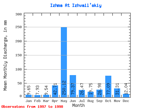
| Statistic | Jan | Feb | Mar | Apr | May | Jun | Jul | Aug | Sep | Oct | Nov | Dec | Annual |
|---|---|---|---|---|---|---|---|---|---|---|---|---|---|
| Mean | 9.65 | 8.00 | 9.54 | 42.70 | 250.08 | 79.37 | 26.47 | 19.75 | 26.98 | 77.08 | 31.31 | 12.04 | 588.97 |
| Standard Deviation | 0.20 | 0.29 | 0.72 | 43.18 | 11.14 | 30.61 | 11.10 | 8.08 | 6.51 | 1.19 | 1.54 | 0.56 | 15.57 |
| Min | 9.51 | 7.79 | 9.03 | 12.17 | 242.20 | 57.72 | 18.62 | 14.04 | 22.38 | 76.23 | 30.22 | 11.65 | 577.97 |
| Max | 9.79 | 8.20 | 10.04 | 73.24 | 257.95 | 101.01 | 34.32 | 25.46 | 31.58 | 77.92 | 32.40 | 12.43 | 599.98 |
| Coefficient of Variation | 0.02 | 0.04 | 0.07 | 1.01 | 0.04 | 0.39 | 0.42 | 0.41 | 0.24 | 0.01 | 0.05 | 0.05 | 0.03 |
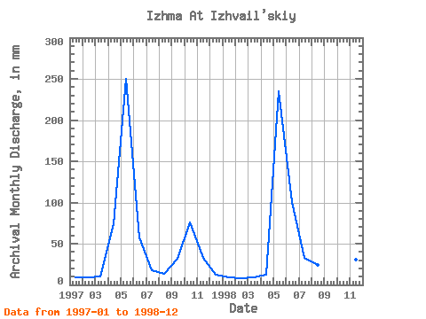
| Year | Jan | Feb | Mar | Apr | May | Jun | Jul | Aug | Sep | Oct | Nov | Dec | Annual | 1997 | 9.51 | 8.20 | 10.04 | 73.24 | 257.95 | 57.72 | 18.62 | 14.04 | 31.58 | 77.92 | 32.40 | 12.43 | 599.98 | 1998 | 9.79 | 7.79 | 9.03 | 12.17 | 242.20 | 101.01 | 34.32 | 25.46 | 22.38 | 76.23 | 30.22 | 11.65 | 577.97 |
|---|
 Return to R-Arctic Net Home Page