|
|
|||||||||||||||||
| Point ID: 7704 | Downloads | Plots | Site Data | Code: 15518000 |
|
|
|||||||||||||||||
| Download | |
|---|---|
| Site Descriptor Information | Site Time Series Data |
| Link to all available data | |
|
|
| View: | Statistics | Time Series |
| Units: | m3/s |
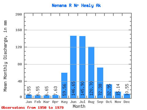
| Statistic | Jan | Feb | Mar | Apr | May | Jun | Jul | Aug | Sep | Oct | Nov | Dec | Annual |
|---|---|---|---|---|---|---|---|---|---|---|---|---|---|
| Mean | 8.55 | 6.60 | 6.65 | 7.63 | 59.55 | 146.65 | 145.88 | 120.68 | 72.39 | 32.95 | 15.14 | 10.55 | 632.58 |
| Standard Deviation | 1.83 | 1.30 | 1.31 | 1.55 | 18.26 | 39.87 | 32.69 | 30.45 | 21.72 | 8.79 | 4.83 | 2.88 | 102.61 |
| Min | 3.50 | 2.65 | 2.91 | 3.00 | 14.09 | 81.31 | 90.00 | 66.02 | 31.29 | 15.85 | 5.99 | 4.02 | 409.74 |
| Max | 11.82 | 8.73 | 9.18 | 11.96 | 98.75 | 223.45 | 235.15 | 200.66 | 125.54 | 53.82 | 26.19 | 21.26 | 819.76 |
| Coefficient of Variation | 0.21 | 0.20 | 0.20 | 0.20 | 0.31 | 0.27 | 0.22 | 0.25 | 0.30 | 0.27 | 0.32 | 0.27 | 0.16 |
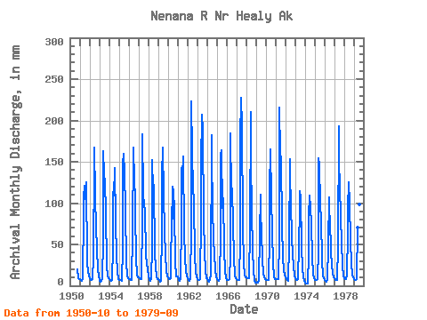
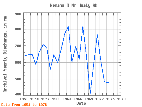
| Year | Jan | Feb | Mar | Apr | May | Jun | Jul | Aug | Sep | Oct | Nov | Dec | Annual | 1950 | 20.76 | 9.05 | 8.66 | 1951 | 8.35 | 6.50 | 6.59 | 9.30 | 90.04 | 106.99 | 125.01 | 107.80 | 125.54 | 29.57 | 16.20 | 12.72 | 642.09 | 1952 | 9.20 | 6.98 | 7.36 | 7.57 | 35.99 | 149.11 | 173.07 | 112.75 | 69.75 | 47.12 | 19.29 | 12.26 | 647.47 | 1953 | 6.59 | 5.03 | 6.59 | 8.90 | 55.80 | 163.06 | 139.22 | 129.69 | 88.70 | 26.09 | 11.13 | 9.96 | 648.43 | 1954 | 8.74 | 6.82 | 5.98 | 6.68 | 47.98 | 113.03 | 113.22 | 146.85 | 78.04 | 37.23 | 17.80 | 8.46 | 587.92 | 1955 | 7.67 | 6.42 | 6.75 | 5.64 | 45.67 | 146.98 | 164.94 | 140.32 | 93.33 | 28.48 | 12.24 | 9.81 | 665.29 | 1956 | 8.43 | 7.12 | 6.75 | 6.48 | 64.72 | 166.77 | 153.45 | 150.30 | 89.07 | 33.92 | 12.98 | 10.96 | 707.87 | 1957 | 10.56 | 8.49 | 7.88 | 7.57 | 83.56 | 183.53 | 116.09 | 98.87 | 91.77 | 37.92 | 26.19 | 21.26 | 692.15 | 1958 | 11.82 | 6.38 | 5.66 | 8.16 | 48.03 | 152.23 | 119.64 | 125.88 | 40.53 | 23.04 | 11.05 | 8.42 | 558.31 | 1959 | 8.71 | 6.72 | 5.20 | 5.94 | 68.55 | 132.98 | 172.91 | 113.74 | 66.40 | 38.86 | 18.55 | 11.65 | 646.49 | 1960 | 10.55 | 7.83 | 7.91 | 8.61 | 98.75 | 81.31 | 123.69 | 118.60 | 90.61 | 30.58 | 11.79 | 11.71 | 598.18 | 1961 | 11.19 | 6.34 | 6.47 | 9.42 | 80.95 | 143.00 | 138.49 | 161.42 | 65.08 | 33.85 | 17.80 | 11.65 | 681.64 | 1962 | 9.35 | 6.56 | 6.44 | 7.71 | 68.11 | 223.45 | 166.48 | 123.17 | 102.76 | 36.33 | 17.21 | 10.27 | 775.97 | 1963 | 8.28 | 6.98 | 7.21 | 7.71 | 85.20 | 146.63 | 214.15 | 194.38 | 80.86 | 43.20 | 18.18 | 8.89 | 815.87 | 1964 | 8.89 | 5.87 | 5.52 | 7.49 | 14.09 | 182.20 | 157.28 | 100.76 | 53.55 | 41.59 | 17.80 | 11.34 | 604.58 | 1965 | 7.97 | 6.14 | 6.59 | 8.83 | 63.30 | 157.72 | 169.85 | 97.63 | 106.35 | 45.13 | 17.80 | 10.69 | 695.55 | 1966 | 7.67 | 6.98 | 7.67 | 8.01 | 37.56 | 184.57 | 116.33 | 121.30 | 73.64 | 36.41 | 10.98 | 9.56 | 619.25 | 1967 | 8.51 | 6.86 | 7.05 | 6.68 | 59.77 | 176.71 | 235.15 | 200.66 | 71.45 | 28.04 | 13.35 | 10.93 | 819.76 | 1968 | 10.12 | 8.73 | 9.18 | 9.38 | 72.80 | 210.39 | 158.04 | 92.96 | 43.64 | 19.73 | 5.99 | 4.02 | 643.02 | 1969 | 3.50 | 3.07 | 3.37 | 6.94 | 63.34 | 110.30 | 90.08 | 66.02 | 31.29 | 15.85 | 9.78 | 8.12 | 409.74 | 1970 | 7.31 | 6.31 | 6.75 | 7.52 | 60.60 | 116.94 | 170.31 | 111.66 | 63.83 | 28.82 | 11.22 | 8.37 | 595.99 | 1971 | 8.28 | 7.54 | 8.28 | 7.91 | 56.96 | 215.14 | 164.48 | 159.58 | 72.18 | 36.55 | 19.18 | 13.44 | 766.70 | 1972 | 10.39 | 7.53 | 7.08 | 6.44 | 51.52 | 153.27 | 137.53 | 101.76 | 59.33 | 38.81 | 24.73 | 12.17 | 608.29 | 1973 | 9.20 | 6.98 | 6.90 | 7.78 | 50.39 | 92.00 | 118.17 | 110.03 | 46.54 | 21.71 | 11.38 | 6.36 | 484.51 | 1974 | 3.79 | 2.65 | 2.91 | 3.00 | 38.88 | 84.88 | 112.96 | 98.63 | 74.14 | 36.27 | 13.55 | 10.04 | 479.04 | 1975 | 7.67 | 6.98 | 7.67 | 7.91 | 43.90 | 154.16 | 151.41 | 101.63 | 80.27 | 31.35 | 11.87 | 9.61 | 612.36 | 1976 | 7.27 | 5.59 | 5.52 | 6.65 | 50.83 | 107.06 | 90.00 | 83.33 | 40.76 | 25.97 | 14.35 | 10.73 | 446.05 | 1977 | 9.20 | 6.98 | 6.90 | 7.17 | 50.25 | 193.33 | 153.45 | 124.61 | 83.40 | 53.82 | 23.93 | 12.94 | 723.66 | 1978 | 9.98 | 8.04 | 7.82 | 11.96 | 66.68 | 94.01 | 129.04 | 104.18 | 54.57 | 28.41 | 13.75 | 10.81 | 536.03 | 1979 | 8.88 | 6.98 | 6.90 | 7.94 | 72.80 | 111.19 | 156.05 | 101.22 | 61.80 |
|---|
 Return to R-Arctic Net Home Page