|
|
|||||||||||||||||
| Point ID: 7620 | Downloads | Plots | Site Data | Code: 71156 |
|
|
|||||||||||||||||
| Download | |
|---|---|
| Site Descriptor Information | Site Time Series Data |
| Link to all available data | |
|
|
| View: | Statistics | Time Series |
| Units: | m3/s |
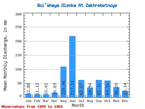
| Statistic | Jan | Feb | Mar | Apr | May | Jun | Jul | Aug | Sep | Oct | Nov | Dec | Annual |
|---|---|---|---|---|---|---|---|---|---|---|---|---|---|
| Mean | 12.88 | 11.22 | 10.40 | 16.69 | 109.44 | 217.31 | 62.27 | 34.93 | 62.11 | 59.33 | 36.09 | 23.14 | 649.08 |
| Standard Deviation | 4.56 | 3.33 | 1.98 | 17.42 | 70.54 | 103.45 | 43.75 | 25.43 | 44.86 | 31.48 | 11.25 | 9.37 | 149.53 |
| Min | 7.79 | 5.95 | 7.30 | 5.42 | 14.98 | 61.08 | 11.58 | 3.79 | 22.68 | 26.84 | 19.07 | 8.84 | 415.30 |
| Max | 20.52 | 16.30 | 13.55 | 55.77 | 194.26 | 373.40 | 155.85 | 82.32 | 155.63 | 114.14 | 52.27 | 40.06 | 816.97 |
| Coefficient of Variation | 0.35 | 0.30 | 0.19 | 1.04 | 0.65 | 0.48 | 0.70 | 0.73 | 0.72 | 0.53 | 0.31 | 0.41 | 0.23 |
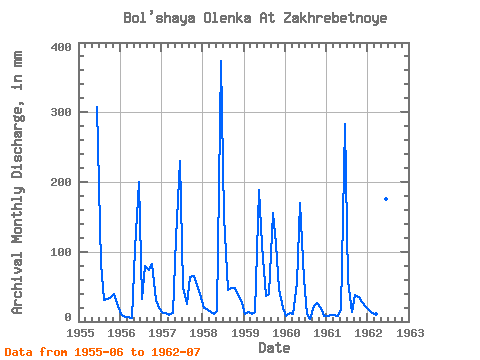
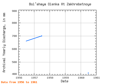
| Year | Jan | Feb | Mar | Apr | May | Jun | Jul | Aug | Sep | Oct | Nov | Dec | Annual | 1955 | 307.00 | 85.06 | 31.39 | 32.88 | 35.94 | 39.52 | 22.45 | 1956 | 11.80 | 5.95 | 7.30 | 5.42 | 108.11 | 200.24 | 33.42 | 82.32 | 73.30 | 84.51 | 30.43 | 20.47 | 662.03 | 1957 | 12.62 | 12.05 | 9.00 | 12.00 | 124.02 | 229.46 | 51.48 | 26.07 | 64.27 | 68.05 | 52.27 | 40.06 | 701.59 | 1958 | 20.52 | 16.30 | 13.55 | 10.78 | 14.98 | 373.40 | 155.85 | 46.32 | 48.49 | 49.66 | 37.39 | 27.44 | 816.97 | 1959 | 11.36 | 12.85 | 10.65 | 12.96 | 194.26 | 109.42 | 37.81 | 40.17 | 155.63 | 114.14 | 45.94 | 20.14 | 763.40 | 1960 | 8.72 | 11.10 | 10.92 | 55.77 | 176.16 | 61.08 | 11.58 | 3.79 | 22.68 | 26.84 | 19.07 | 8.84 | 415.30 | 1961 | 7.79 | 8.25 | 9.82 | 8.50 | 16.85 | 282.57 | 59.82 | 14.49 | 37.55 | 36.16 | 27.99 | 22.55 | 535.22 | 1962 | 17.34 | 12.05 | 11.58 | 11.42 | 131.71 | 175.28 | 63.11 |
|---|
 Return to R-Arctic Net Home Page