|
|
|||||||||||||||||
| Point ID: 7607 | Downloads | Plots | Site Data | Code: 71130 |
|
|
|||||||||||||||||
| Download | |
|---|---|
| Site Descriptor Information | Site Time Series Data |
| Link to all available data | |
|
|
| View: | Statistics | Time Series |
| Units: | m3/s |
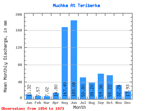
| Statistic | Jan | Feb | Mar | Apr | May | Jun | Jul | Aug | Sep | Oct | Nov | Dec | Annual |
|---|---|---|---|---|---|---|---|---|---|---|---|---|---|
| Mean | 11.32 | 7.63 | 7.02 | 14.80 | 167.38 | 183.08 | 50.80 | 38.20 | 59.35 | 55.21 | 32.26 | 17.93 | 657.18 |
| Standard Deviation | 2.83 | 1.81 | 1.82 | 20.72 | 89.42 | 119.03 | 23.15 | 21.80 | 37.67 | 21.92 | 9.82 | 6.07 | 124.37 |
| Min | 6.25 | 4.34 | 4.46 | 4.32 | 15.03 | 35.42 | 9.07 | 7.44 | 22.46 | 22.76 | 17.57 | 9.82 | 363.09 |
| Max | 15.18 | 10.71 | 10.71 | 72.58 | 330.29 | 447.84 | 101.47 | 81.53 | 155.52 | 89.56 | 48.38 | 29.16 | 809.02 |
| Coefficient of Variation | 0.25 | 0.24 | 0.26 | 1.40 | 0.53 | 0.65 | 0.46 | 0.57 | 0.64 | 0.40 | 0.30 | 0.34 | 0.19 |
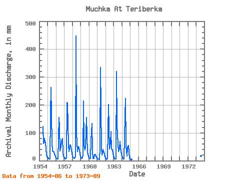
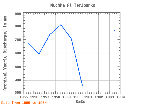
| Year | Jan | Feb | Mar | Apr | May | Jun | Jul | Aug | Sep | Oct | Nov | Dec | Annual | 1954 | 121.97 | 64.12 | 81.53 | 64.94 | 67.10 | 21.31 | 13.39 | 1955 | 12.35 | 7.86 | 6.25 | 6.62 | 171.09 | 262.08 | 66.95 | 36.15 | 33.70 | 29.90 | 24.05 | 16.51 | 672.84 | 1956 | 8.18 | 8.00 | 7.14 | 5.76 | 160.68 | 120.67 | 35.41 | 53.41 | 69.70 | 83.17 | 29.52 | 16.07 | 595.11 | 1957 | 11.46 | 7.73 | 5.95 | 9.36 | 215.73 | 207.36 | 55.64 | 34.37 | 57.17 | 58.92 | 48.38 | 29.16 | 739.18 | 1958 | 14.73 | 10.71 | 10.71 | 8.35 | 15.03 | 447.84 | 101.47 | 34.81 | 47.38 | 52.67 | 38.30 | 22.76 | 809.02 | 1959 | 12.94 | 8.27 | 8.48 | 18.72 | 221.68 | 56.16 | 39.43 | 52.22 | 155.52 | 89.56 | 30.10 | 15.62 | 705.28 | 1960 | 9.97 | 7.18 | 9.07 | 72.58 | 138.22 | 35.42 | 9.07 | 7.44 | 23.18 | 22.76 | 17.57 | 11.61 | 363.09 | 1961 | 8.93 | 6.37 | 7.14 | 4.32 | 47.61 | 334.08 | 48.05 | 21.57 | 40.18 | 31.54 | 30.82 | 14.58 | 598.47 | 1962 | 10.71 | 5.56 | 5.06 | 10.94 | 208.29 | 117.07 | 43.29 | 66.65 | 104.69 | 42.85 | 40.90 | 24.10 | 677.37 | 1963 | 13.84 | 7.86 | 6.99 | 5.90 | 330.29 | 128.16 | 61.30 | 34.96 | 44.93 | 71.71 | 45.07 | 23.66 | 768.84 | 1964 | 15.18 | 10.03 | 5.95 | 5.47 | 165.14 | 223.20 | 57.28 | 16.81 | 48.38 | 57.13 | 28.80 | 9.82 | 642.60 | 1965 | 6.25 | 4.34 | 4.46 | 1973 | 142.99 | 27.52 | 18.45 | 22.46 |
|---|
 Return to R-Arctic Net Home Page