|
|
|||||||||||||||||
| Point ID: 7582 | Downloads | Plots | Site Data | Code: 71055 |
|
|
|||||||||||||||||
| Download | |
|---|---|
| Site Descriptor Information | Site Time Series Data |
| Link to all available data | |
|
|
| View: | Statistics | Time Series |
| Units: | m3/s |
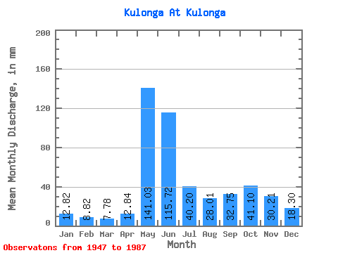
| Statistic | Jan | Feb | Mar | Apr | May | Jun | Jul | Aug | Sep | Oct | Nov | Dec | Annual |
|---|---|---|---|---|---|---|---|---|---|---|---|---|---|
| Mean | 12.82 | 8.89 | 7.79 | 12.83 | 141.02 | 115.72 | 40.19 | 28.00 | 32.76 | 41.10 | 30.20 | 18.30 | 488.31 |
| Standard Deviation | 4.03 | 2.75 | 2.54 | 9.91 | 60.09 | 59.45 | 21.72 | 16.57 | 20.18 | 17.32 | 13.85 | 5.14 | 103.99 |
| Min | 4.50 | 3.42 | 3.50 | 3.39 | 30.03 | 29.80 | 11.01 | 3.50 | 9.93 | 12.26 | 10.42 | 9.01 | 255.87 |
| Max | 21.27 | 16.42 | 12.76 | 53.78 | 260.29 | 266.47 | 98.11 | 75.33 | 119.67 | 90.60 | 80.91 | 29.28 | 674.46 |
| Coefficient of Variation | 0.31 | 0.31 | 0.33 | 0.77 | 0.43 | 0.51 | 0.54 | 0.59 | 0.62 | 0.42 | 0.46 | 0.28 | 0.21 |
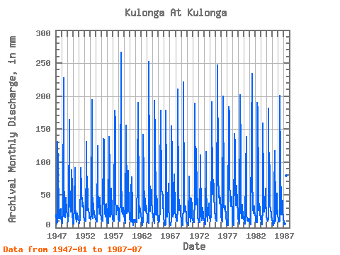
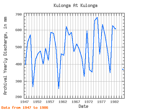
| Year | Jan | Feb | Mar | Apr | May | Jun | Jul | Aug | Sep | Oct | Nov | Dec | Annual | 1947 | 21.02 | 8.66 | 6.01 | 8.96 | 135.40 | 93.75 | 23.78 | 15.27 | 14.54 | 28.28 | 28.34 | 14.52 | 396.96 | 1948 | 11.26 | 6.38 | 8.51 | 25.44 | 235.51 | 91.08 | 19.27 | 16.27 | 22.04 | 47.05 | 25.44 | 24.53 | 529.20 | 1949 | 21.27 | 12.31 | 9.26 | 23.98 | 169.19 | 66.62 | 33.04 | 37.29 | 24.47 | 90.60 | 62.26 | 25.28 | 572.21 | 1950 | 6.01 | 5.47 | 7.01 | 34.64 | 93.61 | 34.40 | 17.02 | 9.01 | 11.38 | 23.28 | 14.29 | 12.76 | 267.67 | 1951 | 11.51 | 8.21 | 6.76 | 14.29 | 74.33 | 90.60 | 62.07 | 34.04 | 44.33 | 32.29 | 32.70 | 18.02 | 428.17 | 1952 | 11.76 | 9.58 | 10.26 | 9.69 | 110.62 | 131.05 | 27.53 | 61.32 | 30.04 | 28.53 | 18.65 | 15.27 | 463.08 | 1953 | 17.02 | 12.77 | 12.76 | 19.38 | 200.97 | 76.55 | 15.27 | 38.54 | 29.55 | 22.02 | 16.71 | 17.52 | 476.35 | 1954 | 14.27 | 9.81 | 9.76 | 9.21 | 128.64 | 56.93 | 39.04 | 22.02 | 30.77 | 46.80 | 22.04 | 13.52 | 400.40 | 1955 | 13.77 | 10.03 | 10.01 | 11.87 | 139.91 | 133.96 | 49.81 | 24.28 | 17.20 | 25.28 | 36.09 | 22.02 | 492.82 | 1956 | 11.51 | 7.07 | 7.26 | 7.27 | 142.91 | 84.30 | 17.02 | 17.52 | 31.01 | 62.07 | 22.77 | 14.52 | 423.01 | 1957 | 12.76 | 9.81 | 10.26 | 14.05 | 183.96 | 158.91 | 49.56 | 20.27 | 31.49 | 35.04 | 32.70 | 29.28 | 586.22 | 1958 | 14.27 | 9.12 | 10.26 | 11.87 | 49.56 | 266.47 | 85.85 | 26.28 | 20.83 | 31.54 | 31.01 | 23.28 | 581.55 | 1959 | 18.52 | 13.45 | 6.76 | 8.96 | 160.18 | 32.95 | 23.03 | 26.53 | 86.24 | 78.84 | 31.73 | 16.02 | 500.68 | 1960 | 12.51 | 11.40 | 9.26 | 53.78 | 79.34 | 29.80 | 11.01 | 3.50 | 9.93 | 12.26 | 10.42 | 12.76 | 255.87 | 1961 | 10.51 | 8.66 | 8.26 | 12.11 | 80.34 | 189.92 | 28.78 | 15.02 | 32.70 | 28.53 | 24.95 | 21.02 | 461.85 | 1962 | 13.27 | 7.07 | 4.25 | 10.66 | 146.41 | 70.49 | 26.78 | 57.06 | 34.64 | 25.28 | 33.43 | 25.78 | 452.51 | 1963 | 17.52 | 8.66 | 8.01 | 6.54 | 260.29 | 89.87 | 37.54 | 26.53 | 42.88 | 59.82 | 43.85 | 23.78 | 620.88 | 1964 | 20.52 | 16.42 | 11.26 | 7.03 | 199.47 | 135.66 | 35.54 | 20.27 | 47.96 | 40.80 | 23.50 | 13.27 | 570.00 | 1965 | 8.51 | 9.81 | 10.26 | 27.37 | 74.58 | 177.81 | 56.81 | 60.82 | 51.11 | 51.06 | 43.12 | 14.77 | 586.22 | 1966 | 9.26 | 6.38 | 4.25 | 4.84 | 183.71 | 74.61 | 32.29 | 17.77 | 29.07 | 69.08 | 31.98 | 13.27 | 473.15 | 1967 | 5.51 | 5.47 | 3.75 | 13.81 | 159.93 | 108.04 | 29.03 | 17.52 | 21.32 | 46.80 | 80.91 | 27.28 | 517.89 | 1968 | 17.02 | 11.40 | 11.26 | 10.17 | 30.03 | 210.27 | 37.29 | 43.80 | 25.92 | 34.54 | 34.16 | 23.03 | 490.36 | 1969 | 10.01 | 4.56 | 3.50 | 3.39 | 40.80 | 220.93 | 37.79 | 24.53 | 31.49 | 34.04 | 16.47 | 9.01 | 438.01 | 1970 | 7.26 | 7.75 | 7.26 | 3.88 | 80.84 | 70.73 | 21.77 | 9.26 | 24.71 | 46.05 | 32.22 | 17.27 | 328.13 | 1971 | 11.51 | 8.89 | 8.51 | 8.24 | 46.55 | 188.95 | 59.57 | 36.04 | 119.67 | 50.31 | 38.52 | 17.77 | 596.30 | 1972 | 11.26 | 8.21 | 8.01 | 8.48 | 114.38 | 99.32 | 20.02 | 11.51 | 20.83 | 32.04 | 19.14 | 15.02 | 367.22 | 1973 | 13.52 | 7.30 | 5.01 | 5.09 | 119.13 | 65.65 | 22.52 | 11.01 | 20.59 | 24.78 | 37.06 | 22.78 | 352.96 | 1974 | 15.27 | 11.86 | 10.01 | 19.38 | 122.89 | 190.65 | 52.81 | 75.33 | 62.26 | 52.81 | 25.19 | 18.02 | 655.53 | 1975 | 15.52 | 12.09 | 11.51 | 10.42 | 255.29 | 85.75 | 76.08 | 55.31 | 37.06 | 49.81 | 44.81 | 26.03 | 674.46 | 1976 | 17.27 | 11.86 | 9.76 | 13.32 | 205.73 | 57.90 | 31.29 | 30.78 | 25.19 | 34.04 | 15.50 | 9.76 | 458.90 | 1977 | 4.50 | 3.42 | 3.75 | 6.06 | 188.96 | 173.20 | 69.58 | 47.30 | 32.70 | 41.30 | 46.99 | 17.27 | 632.43 | 1978 | 13.02 | 4.56 | 4.00 | 4.12 | 147.16 | 126.21 | 65.07 | 34.79 | 48.93 | 65.82 | 36.34 | 25.28 | 572.46 | 1979 | 13.52 | 10.95 | 7.51 | 5.81 | 208.48 | 112.64 | 29.28 | 15.02 | 18.89 | 36.04 | 15.02 | 16.77 | 487.17 | 1980 | 14.02 | 9.58 | 6.51 | 7.03 | 90.85 | 138.08 | 21.02 | 11.76 | 10.42 | 13.77 | 13.32 | 14.02 | 350.50 | 1981 | 11.26 | 7.53 | 5.01 | 5.81 | 151.17 | 234.25 | 81.09 | 29.03 | 22.04 | 34.04 | 23.25 | 22.02 | 625.30 | 1982 | 15.52 | 8.89 | 8.51 | 8.24 | 196.47 | 176.84 | 67.33 | 26.78 | 35.61 | 29.03 | 22.29 | 14.52 | 607.85 | 1983 | 9.51 | 5.70 | 5.51 | 31.73 | 164.18 | 65.65 | 25.03 | 24.78 | 33.43 | 61.32 | 45.54 | 17.02 | 486.92 | 1984 | 14.02 | 11.86 | 10.76 | 11.87 | 186.71 | 45.78 | 98.11 | 34.79 | 27.37 | 21.77 | 17.20 | 12.76 | 488.64 | 1985 | 9.76 | 5.93 | 4.25 | 7.75 | 55.31 | 116.76 | 23.03 | 10.01 | 29.55 | 54.31 | 33.19 | 20.27 | 370.17 | 1986 | 12.26 | 8.89 | 9.01 | 10.17 | 206.98 | 91.81 | 32.29 | 21.02 | 20.35 | 43.05 | 24.95 | 15.02 | 492.57 | 1987 | 7.01 | 6.61 | 5.76 | 9.45 | 160.93 | 79.21 | 56.81 |
|---|
 Return to R-Arctic Net Home Page