|
|
|||||||||||||||||
| Point ID: 7331 | Downloads | Plots | Site Data | Code: 49141 |
|
|
|||||||||||||||||
| Download | |
|---|---|
| Site Descriptor Information | Site Time Series Data |
| Link to all available data | |
|
|
| View: | Statistics | Time Series |
| Units: | m3/s |
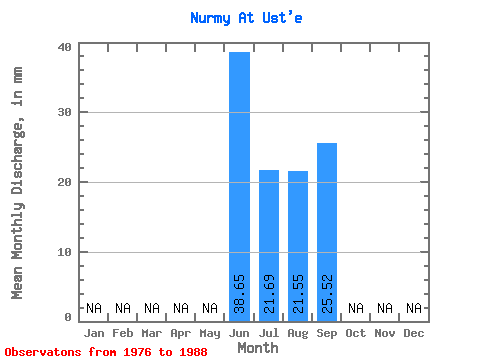
| Statistic | Jan | Feb | Mar | Apr | May | Jun | Jul | Aug | Sep | Oct | Nov | Dec | Annual |
|---|---|---|---|---|---|---|---|---|---|---|---|---|---|
| Mean | 38.65 | 21.67 | 21.57 | 25.49 | |||||||||
| Standard Deviation | 22.94 | 15.98 | 17.04 | 13.59 | |||||||||
| Min | 15.32 | 4.96 | 2.96 | 2.87 | |||||||||
| Max | 77.29 | 59.20 | 61.27 | 57.97 | |||||||||
| Coefficient of Variation | 0.59 | 0.74 | 0.79 | 0.53 |
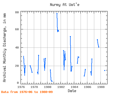
| Year | Jan | Feb | Mar | Apr | May | Jun | Jul | Aug | Sep | Oct | Nov | Dec | Annual | 1976 | 30.65 | 20.65 | 9.64 | 19.99 | 1977 | 19.99 | 17.90 | 15.83 | 12.66 | 1978 | 13.08 | 11.02 | 31.32 | 1979 | 28.23 | 15.15 | 27.99 | 1980 | 15.32 | 4.96 | 2.96 | 2.87 | 1981 | 77.29 | 59.20 | 61.27 | 57.97 | 1982 | 36.65 | 15.83 | 37.17 | 26.65 | 1983 | 51.97 | 14.46 | 14.46 | 19.32 | 1984 | 23.41 | 30.98 | 29.32 | 1985 | 8.95 | 11.70 | 15.99 | 1986 | 13.77 | 9.64 | 27.32 | 1987 | 50.26 | 45.44 | 40.65 | 1988 | 11.02 | 15.15 | 19.32 |
|---|
 Return to R-Arctic Net Home Page