|
|
|||||||||||||||||
| Point ID: 718 | Downloads | Plots | Site Data | Code: 07DA019 |
|
|
|||||||||||||||||
| Download | |
|---|---|
| Site Descriptor Information | Site Time Series Data |
| Link to all available data | |
|
|
| View: | Statistics | Time Series |
| Units: | m3/s |
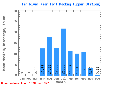
| Statistic | Jan | Feb | Mar | Apr | May | Jun | Jul | Aug | Sep | Oct | Nov | Dec | Annual |
|---|---|---|---|---|---|---|---|---|---|---|---|---|---|
| Mean | 0.00 | 0.00 | 0.00 | 12.56 | 17.58 | 12.88 | 21.53 | 11.34 | 10.12 | 11.00 | 3.50 | 0.52 | 100.53 |
| Standard Deviation | 0.48 | 0.68 | 0.29 | ||||||||||
| Min | 0.00 | 0.00 | 0.00 | 12.56 | 17.58 | 12.88 | 21.53 | 11.34 | 10.12 | 10.66 | 3.02 | 0.31 | 100.53 |
| Max | 0.00 | 0.00 | 0.00 | 12.56 | 17.58 | 12.88 | 21.53 | 11.34 | 10.12 | 11.34 | 3.98 | 0.73 | 100.53 |
| Coefficient of Variation | 0.04 | 0.19 | 0.57 |
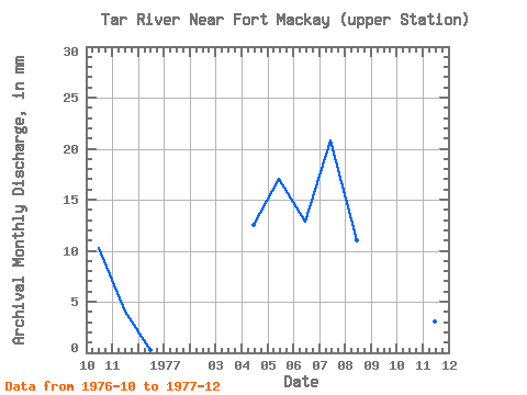
| Year | Jan | Feb | Mar | Apr | May | Jun | Jul | Aug | Sep | Oct | Nov | Dec | Annual | 1976 | 10.66 | 3.98 | 0.31 | 1977 | 0.00 | 0.00 | 0.00 | 12.56 | 17.58 | 12.88 | 21.53 | 11.34 | 10.12 | 11.34 | 3.02 | 0.73 | 100.53 |
|---|
 Return to R-Arctic Net Home Page