|
|
|||||||||||||||||
| Point ID: 7171 | Downloads | Plots | Site Data | Code: 12086 |
|
|
|||||||||||||||||
| Download | |
|---|---|
| Site Descriptor Information | Site Time Series Data |
| Link to all available data | |
|
|
| View: | Statistics | Time Series |
| Units: | m3/s |
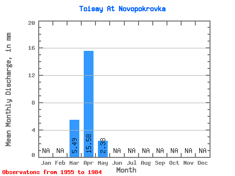
| Statistic | Jan | Feb | Mar | Apr | May | Jun | Jul | Aug | Sep | Oct | Nov | Dec | Annual |
|---|---|---|---|---|---|---|---|---|---|---|---|---|---|
| Mean | 5.48 | 15.60 | 2.40 | ||||||||||
| Standard Deviation | 8.12 | 11.59 | 2.39 | ||||||||||
| Min | 0.03 | 0.79 | 0.07 | ||||||||||
| Max | 19.59 | 44.25 | 6.21 | ||||||||||
| Coefficient of Variation | 1.48 | 0.74 | 1.00 |
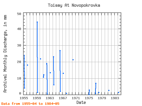
| Year | Jan | Feb | Mar | Apr | May | Jun | Jul | Aug | Sep | Oct | Nov | Dec | Annual | 1955 | 24.02 | 4.25 | 1956 | 18.02 | 1959 | 44.25 | 1.31 | 1960 | 21.81 | 1961 | 11.10 | 12.01 | 1962 | 19.59 | 17.70 | 0.42 | 1963 | 13.28 | 1964 | 23.07 | 6.21 | 1966 | 26.87 | 2.12 | 1967 | 12.96 | 1968 | 0.79 | 1970 | 21.18 | 1975 | 0.03 | 2.72 | 1977 | 0.59 | 6.95 | 1978 | 1.44 | 1981 | 2.53 | 1984 | 0.13 | 1.36 | 0.07 |
|---|
 Return to R-Arctic Net Home Page