|
|
|||||||||||||||||
| Point ID: 7075 | Downloads | Plots | Site Data | Code: 11482 |
|
|
|||||||||||||||||
| Download | |
|---|---|
| Site Descriptor Information | Site Time Series Data |
| Link to all available data | |
|
|
| View: | Statistics | Time Series |
| Units: | m3/s |
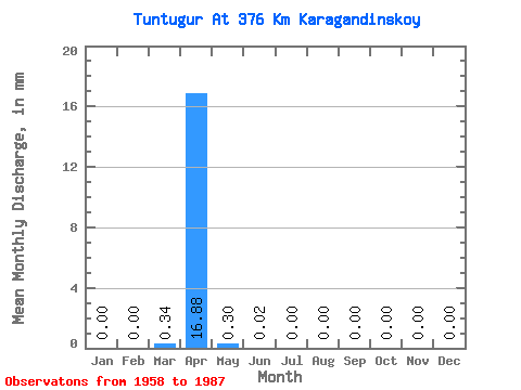
| Statistic | Jan | Feb | Mar | Apr | May | Jun | Jul | Aug | Sep | Oct | Nov | Dec | Annual |
|---|---|---|---|---|---|---|---|---|---|---|---|---|---|
| Mean | 0.00 | 0.00 | 0.34 | 16.88 | 0.30 | 0.02 | 0.00 | 0.00 | 0.00 | 0.00 | 0.00 | 0.00 | 40.44 |
| Standard Deviation | 0.00 | 0.00 | 0.58 | 13.55 | 0.96 | 0.02 | 0.00 | 0.00 | 0.00 | 0.00 | 0.00 | 0.00 | 14.75 |
| Min | 0.00 | 0.00 | 0.00 | 0.38 | 0.00 | 0.00 | 0.00 | 0.00 | 0.00 | 0.00 | 0.00 | 0.00 | 30.01 |
| Max | 0.00 | 0.00 | 1.50 | 45.81 | 4.46 | 0.04 | 0.01 | 0.00 | 0.00 | 0.00 | 0.00 | 0.00 | 50.86 |
| Coefficient of Variation | 1.73 | 0.80 | 3.20 | 1.06 | 1.73 | 0.36 |
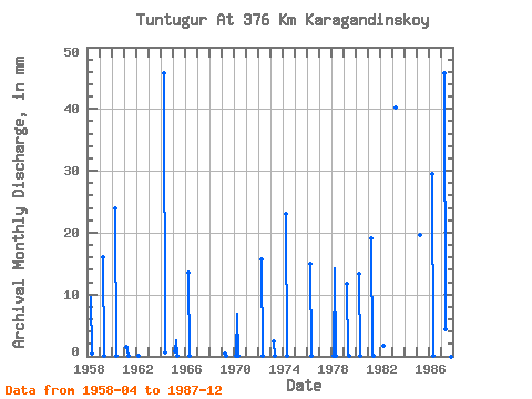
| Year | Jan | Feb | Mar | Apr | May | Jun | Jul | Aug | Sep | Oct | Nov | Dec | Annual | 1958 | 9.63 | 0.49 | 1959 | 16.02 | 0.01 | 1960 | 23.88 | 0.12 | 1961 | 1.50 | 0.95 | 0.01 | 1962 | 0.01 | 1964 | 45.81 | 0.58 | 1965 | 0.76 | 2.60 | 0.01 | 1966 | 13.62 | 0.09 | 0.00 | 1969 | 0.38 | 0.10 | 1970 | 0.07 | 6.86 | 0.01 | 1971 | 1972 | 15.63 | 0.01 | 1973 | 2.45 | 0.05 | 1974 | 23.02 | 0.08 | 0.02 | 1976 | 14.96 | 0.02 | 1978 | 0.02 | 14.28 | 0.06 | 1979 | 11.79 | 0.14 | 0.04 | 0.01 | 1980 | 13.39 | 0.01 | 1981 | 19.06 | 0.03 | 0.04 | 1982 | 1.77 | 0.00 | 1983 | 40.20 | 1985 | 19.59 | 0.00 | 1986 | 0.00 | 0.00 | 0.00 | 29.55 | 0.02 | 0.00 | 0.00 | 0.00 | 0.00 | 0.00 | 0.00 | 0.00 | 30.01 | 1987 | 0.00 | 0.00 | 0.00 | 45.81 | 4.46 | 0.00 | 0.00 | 0.00 | 0.00 | 0.00 | 0.00 | 0.00 | 50.86 |
|---|
 Return to R-Arctic Net Home Page