|
|
|||||||||||||||||
| Point ID: 6989 | Downloads | Plots | Site Data | Code: 11219 |
|
|
|||||||||||||||||
| Download | |
|---|---|
| Site Descriptor Information | Site Time Series Data |
| Link to all available data | |
|
|
| View: | Statistics | Time Series |
| Units: | m3/s |
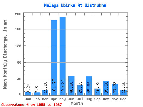
| Statistic | Jan | Feb | Mar | Apr | May | Jun | Jul | Aug | Sep | Oct | Nov | Dec | Annual |
|---|---|---|---|---|---|---|---|---|---|---|---|---|---|
| Mean | 9.20 | 7.37 | 13.20 | 181.76 | 190.19 | 46.60 | 25.53 | 45.88 | 16.73 | 35.50 | 27.33 | 12.56 | 610.70 |
| Standard Deviation | 2.44 | 1.78 | 9.18 | 51.10 | 100.36 | 35.47 | 18.41 | 153.62 | 9.56 | 25.02 | 13.21 | 3.73 | 194.43 |
| Min | 6.28 | 3.67 | 5.37 | 89.87 | 44.91 | 13.17 | 6.64 | 6.23 | 5.81 | 10.99 | 7.97 | 6.42 | 364.95 |
| Max | 15.65 | 12.50 | 55.65 | 272.00 | 402.25 | 169.33 | 85.69 | 911.95 | 52.53 | 125.36 | 52.80 | 20.22 | 1275.28 |
| Coefficient of Variation | 0.27 | 0.24 | 0.70 | 0.28 | 0.53 | 0.76 | 0.72 | 3.35 | 0.57 | 0.70 | 0.48 | 0.30 | 0.32 |
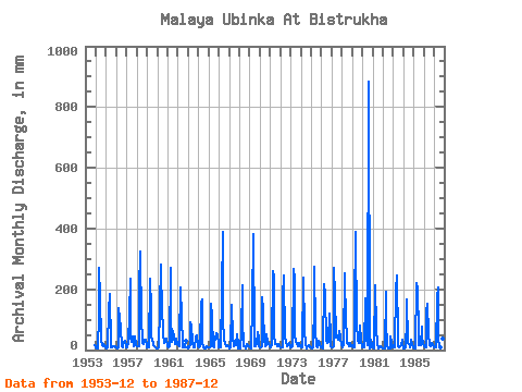
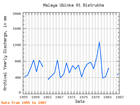
| Year | Jan | Feb | Mar | Apr | May | Jun | Jul | Aug | Sep | Oct | Nov | Dec | Annual | 1953 | 16.25 | 1954 | 8.02 | 5.10 | 6.61 | 114.40 | 281.02 | 169.33 | 34.72 | 14.93 | 21.17 | 14.85 | 1955 | 8.46 | 7.38 | 9.42 | 131.20 | 192.03 | 13.73 | 10.88 | 8.15 | 11.92 | 12.15 | 9.63 | 12.95 | 426.37 | 1956 | 7.96 | 4.97 | 7.71 | 138.93 | 110.21 | 72.80 | 13.69 | 9.75 | 15.41 | 28.93 | 30.40 | 9.51 | 451.08 | 1957 | 8.04 | 7.43 | 22.54 | 117.33 | 241.35 | 41.60 | 26.73 | 47.94 | 11.04 | 30.58 | 44.80 | 16.86 | 612.91 | 1958 | 13.61 | 10.82 | 13.00 | 196.53 | 333.37 | 88.80 | 50.14 | 23.17 | 18.85 | 36.64 | 32.27 | 11.27 | 825.64 | 1959 | 7.41 | 7.41 | 9.64 | 235.20 | 139.96 | 40.53 | 39.40 | 17.61 | 12.11 | 13.06 | 7.97 | 7.05 | 538.07 | 1960 | 6.75 | 7.98 | 8.29 | 137.07 | 292.05 | 113.60 | 85.69 | 57.58 | 23.76 | 40.50 | 36.80 | 14.35 | 820.55 | 1961 | 11.32 | 8.81 | 14.66 | 272.00 | 119.57 | 26.93 | 63.64 | 42.43 | 21.33 | 40.23 | 38.13 | 20.22 | 679.63 | 1962 | 15.65 | 12.50 | 32.79 | 206.67 | 109.93 | 22.56 | 10.58 | 8.71 | 9.28 | 31.13 | 1963 | 10.44 | 8.21 | 19.56 | 89.87 | 79.07 | 26.03 | 8.71 | 8.02 | 10.24 | 42.70 | 48.00 | 14.19 | 364.95 | 1964 | 9.31 | 8.26 | 11.52 | 154.40 | 171.92 | 28.00 | 8.95 | 6.67 | 5.95 | 13.91 | 9.60 | 8.68 | 436.57 | 1965 | 8.90 | 6.93 | 12.87 | 150.67 | 114.34 | 13.89 | 8.65 | 34.44 | 33.60 | 57.86 | 49.60 | 19.20 | 510.52 | 1966 | 8.62 | 7.10 | 9.86 | 189.07 | 402.25 | 97.33 | 39.67 | 20.25 | 14.19 | 17.99 | 17.47 | 11.41 | 831.29 | 1967 | 7.33 | 7.68 | 13.86 | 149.07 | 44.91 | 14.03 | 32.51 | 25.98 | 17.33 | 54.83 | 14.85 | 6.42 | 388.93 | 1968 | 7.14 | 5.60 | 55.65 | 211.47 | 101.39 | 13.17 | 13.28 | 6.72 | 11.12 | 22.15 | 14.05 | 13.06 | 474.97 | 1969 | 7.91 | 5.72 | 6.70 | 149.07 | 393.99 | 34.93 | 13.83 | 12.89 | 18.59 | 60.61 | 40.53 | 14.16 | 753.80 | 1970 | 7.66 | 7.96 | 12.31 | 173.33 | 134.45 | 32.80 | 11.46 | 18.10 | 52.53 | 28.93 | 22.83 | 11.88 | 514.96 | 1971 | 14.82 | 7.08 | 15.95 | 261.60 | 249.89 | 48.53 | 21.49 | 19.18 | 11.15 | 11.49 | 18.08 | 11.63 | 690.24 | 1972 | 9.29 | 7.78 | 10.11 | 178.93 | 252.92 | 41.33 | 31.68 | 11.65 | 12.48 | 17.74 | 25.04 | 10.41 | 607.61 | 1973 | 9.31 | 8.74 | 14.44 | 265.87 | 242.73 | 45.07 | 30.03 | 21.16 | 13.41 | 25.13 | 20.48 | 13.64 | 709.34 | 1974 | 10.61 | 8.76 | 10.99 | 237.33 | 66.67 | 14.83 | 8.79 | 7.36 | 13.41 | 15.81 | 10.11 | 7.69 | 414.79 | 1975 | 7.52 | 6.12 | 8.93 | 152.27 | 283.78 | 65.33 | 12.43 | 10.36 | 20.56 | 30.31 | 21.04 | 9.48 | 625.90 | 1976 | 8.87 | 7.21 | 7.30 | 217.07 | 185.42 | 29.60 | 41.33 | 24.27 | 26.45 | 125.36 | 52.80 | 12.73 | 736.48 | 1977 | 10.22 | 8.71 | 11.30 | 269.33 | 188.18 | 42.93 | 43.81 | 49.59 | 35.20 | 63.64 | 40.27 | 15.18 | 777.88 | 1978 | 8.38 | 6.80 | 14.93 | 252.53 | 86.79 | 117.60 | 25.48 | 25.59 | 13.31 | 24.91 | 24.11 | 12.98 | 616.35 | 1979 | 14.82 | 8.74 | 10.58 | 138.13 | 402.25 | 66.40 | 57.03 | 32.23 | 24.48 | 84.58 | 29.87 | 14.69 | 877.24 | 1980 | 7.91 | 7.81 | 9.26 | 171.73 | 65.85 | 36.80 | 15.37 | 911.95 | 5.81 | 10.99 | 33.33 | 12.76 | 1275.28 | 1981 | 7.83 | 6.28 | 10.41 | 212.00 | 76.04 | 16.08 | 13.55 | 7.14 | 7.39 | 12.43 | 9.47 | 6.80 | 387.09 | 1982 | 6.28 | 4.97 | 5.98 | 190.93 | 98.91 | 13.28 | 6.64 | 6.23 | 6.64 | 47.39 | 24.85 | 7.94 | 420.67 | 1983 | 8.10 | 7.38 | 17.16 | 196.53 | 255.13 | 30.67 | 11.38 | 9.95 | 13.04 | 17.33 | 34.13 | 18.54 | 617.89 | 1984 | 6.42 | 3.67 | 9.20 | 99.73 | 170.54 | 23.49 | 20.75 | 15.76 | 7.55 | 33.61 | 14.51 | 10.41 | 413.28 | 1985 | 6.70 | 3.84 | 5.37 | 222.13 | 206.91 | 55.20 | 18.10 | 20.88 | 17.15 | 79.62 | 44.27 | 19.51 | 698.55 | 1986 | 11.76 | 8.59 | 10.74 | 128.00 | 158.42 | 56.27 | 16.92 | 13.22 | 12.96 | 23.91 | 18.93 | 9.29 | 468.48 | 1987 | 9.34 | 8.23 | 9.01 | 169.60 | 214.07 | 30.93 | 20.72 | 10.00 | 19.28 | 35.54 | 36.27 | 13.25 | 575.05 |
|---|
 Return to R-Arctic Net Home Page