|
|
|||||||||||||||||
| Point ID: 6814 | Downloads | Plots | Site Data | Code: 10384 |
|
|
|||||||||||||||||
| Download | |
|---|---|
| Site Descriptor Information | Site Time Series Data |
| Link to all available data | |
|
|
| View: | Statistics | Time Series |
| Units: | m3/s |
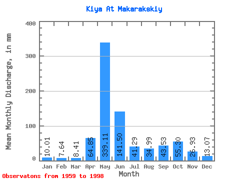
| Statistic | Jan | Feb | Mar | Apr | May | Jun | Jul | Aug | Sep | Oct | Nov | Dec | Annual |
|---|---|---|---|---|---|---|---|---|---|---|---|---|---|
| Mean | 10.01 | 7.71 | 8.41 | 64.85 | 339.06 | 141.50 | 41.28 | 34.99 | 43.53 | 55.29 | 26.93 | 13.07 | 782.28 |
| Standard Deviation | 3.01 | 2.11 | 2.03 | 38.00 | 71.75 | 76.00 | 19.11 | 15.25 | 21.88 | 21.81 | 15.60 | 5.81 | 124.04 |
| Min | 4.67 | 3.82 | 4.55 | 11.90 | 164.44 | 36.68 | 17.07 | 12.53 | 12.73 | 15.66 | 9.78 | 5.80 | 552.22 |
| Max | 16.37 | 13.06 | 12.84 | 150.82 | 500.36 | 311.50 | 101.01 | 79.09 | 82.61 | 110.41 | 80.34 | 36.80 | 1032.01 |
| Coefficient of Variation | 0.30 | 0.27 | 0.24 | 0.59 | 0.21 | 0.54 | 0.46 | 0.44 | 0.50 | 0.39 | 0.58 | 0.45 | 0.16 |
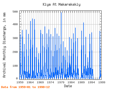
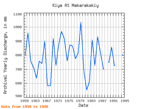
| Year | Jan | Feb | Mar | Apr | May | Jun | Jul | Aug | Sep | Oct | Nov | Dec | Annual | 1959 | 7.70 | 4.72 | 6.81 | 82.61 | 336.71 | 193.26 | 45.34 | 32.34 | 31.91 | 34.22 | 20.24 | 10.57 | 803.11 | 1960 | 7.91 | 7.99 | 7.38 | 43.43 | 369.60 | 259.96 | 90.83 | 40.56 | 61.54 | 40.80 | 19.10 | 13.62 | 958.74 | 1961 | 11.43 | 5.66 | 8.93 | 149.31 | 263.88 | 72.76 | 52.38 | 36.80 | 60.71 | 54.03 | 27.82 | 16.44 | 757.19 | 1962 | 15.82 | 10.27 | 10.10 | 89.43 | 370.38 | 73.36 | 39.31 | 13.31 | 15.46 | 56.46 | 9.78 | 9.79 | 707.79 | 1963 | 7.82 | 3.82 | 4.55 | 11.90 | 339.06 | 107.62 | 20.91 | 16.05 | 41.91 | 37.43 | 40.55 | 9.63 | 636.70 | 1964 | 7.91 | 5.52 | 5.93 | 18.64 | 436.15 | 155.37 | 34.53 | 29.60 | 20.39 | 23.10 | 10.31 | 15.97 | 756.94 | 1965 | 11.20 | 7.28 | 8.93 | 22.21 | 454.16 | 60.25 | 17.07 | 12.53 | 63.28 | 51.99 | 24.02 | 15.27 | 741.01 | 1966 | 11.12 | 7.49 | 7.17 | 15.69 | 451.03 | 281.94 | 43.54 | 18.79 | 12.73 | 15.66 | 27.06 | 11.82 | 899.55 | 1967 | 7.62 | 6.85 | 7.21 | 92.46 | 238.83 | 52.07 | 40.48 | 26.39 | 41.15 | 46.83 | 16.60 | 10.73 | 583.94 | 1968 | 8.54 | 6.17 | 10.49 | 101.56 | 194.98 | 54.57 | 48.55 | 55.28 | 44.03 | 40.80 | 11.14 | 10.18 | 583.25 | 1969 | 8.14 | 6.76 | 6.38 | 21.52 | 369.60 | 311.50 | 24.90 | 35.08 | 27.82 | 70.86 | 30.24 | 10.26 | 919.90 | 1970 | 7.58 | 5.87 | 6.41 | 68.29 | 337.49 | 159.16 | 27.95 | 42.44 | 18.19 | 32.89 | 15.23 | 9.01 | 726.47 | 1971 | 11.28 | 8.49 | 7.91 | 83.37 | 396.22 | 162.95 | 83.78 | 29.21 | 27.21 | 27.25 | 32.06 | 11.98 | 876.67 | 1972 | 10.34 | 8.21 | 7.99 | 101.56 | 343.75 | 176.59 | 101.01 | 57.16 | 73.52 | 55.44 | 28.34 | 8.54 | 968.18 | 1973 | 7.37 | 6.20 | 6.49 | 103.07 | 372.73 | 258.44 | 45.10 | 36.18 | 13.87 | 25.68 | 33.04 | 16.21 | 921.72 | 1974 | 10.26 | 8.70 | 6.80 | 150.82 | 337.49 | 92.46 | 23.65 | 17.15 | 41.15 | 51.05 | 11.97 | 11.98 | 760.30 | 1975 | 10.02 | 8.28 | 10.81 | 23.95 | 321.05 | 306.95 | 26.15 | 19.89 | 48.43 | 53.01 | 35.77 | 10.10 | 873.05 | 1976 | 10.26 | 8.92 | 9.32 | 40.77 | 384.47 | 128.84 | 32.97 | 54.34 | 81.85 | 87.70 | 17.96 | 11.75 | 863.21 | 1977 | 7.83 | 8.28 | 9.79 | 87.92 | 341.41 | 93.22 | 34.14 | 38.29 | 57.98 | 69.30 | 16.30 | 14.96 | 774.54 | 1978 | 12.06 | 7.78 | 8.85 | 97.01 | 324.96 | 136.42 | 48.63 | 47.37 | 37.74 | 48.39 | 35.47 | 14.41 | 815.15 | 1979 | 14.02 | 12.98 | 8.93 | 24.63 | 500.36 | 206.91 | 38.29 | 56.14 | 51.46 | 80.65 | 32.89 | 11.82 | 1032.01 | 1980 | 5.93 | 6.01 | 8.85 | 65.25 | 285.03 | 70.33 | 67.97 | 54.11 | 38.88 | 39.62 | 27.89 | 17.30 | 682.02 | 1981 | 15.74 | 10.70 | 11.75 | 91.70 | 240.39 | 47.90 | 18.48 | 26.07 | 30.16 | 39.86 | 12.51 | 9.95 | 552.22 | 1982 | 8.30 | 7.02 | 7.03 | 141.73 | 215.34 | 36.68 | 23.26 | 16.91 | 17.43 | 88.48 | 33.65 | 19.18 | 612.14 | 1983 | 16.37 | 10.92 | 12.84 | 38.20 | 316.35 | 200.08 | 41.50 | 32.18 | 34.18 | 110.41 | 80.34 | 19.42 | 908.97 | 1984 | 15.82 | 9.28 | 9.95 | 41.61 | 302.25 | 147.03 | 53.48 | 27.48 | 20.24 | 48.78 | 29.79 | 26.78 | 728.02 | 1985 | 12.61 | 9.28 | 10.88 | 38.65 | 342.97 | 201.60 | 35.94 | 79.09 | 55.48 | 60.61 | 50.40 | 36.80 | 929.73 | 1986 | 13.94 | 7.78 | 5.73 | 29.03 | 386.04 | 178.86 | 30.85 | 43.22 | 42.06 | 49.25 | 18.72 | 8.85 | 809.24 | 1987 | 5.67 | 5.73 | 6.80 | 34.41 | 308.52 | 97.01 | 41.66 | 34.61 | 79.58 | 69.46 | 14.32 | 9.95 | 702.91 | 1989 | 9.32 | 13.06 | 12.06 | 77.31 | 364.11 | 142.48 | 26.31 | 15.82 | 14.70 | 47.92 | 23.57 | 7.52 | 750.32 | 1990 | 8.46 | 8.35 | 9.63 | 53.81 | 425.19 | 81.09 | 45.89 | 50.04 | 56.31 | 97.10 | 19.78 | 9.24 | 857.06 | 1991 | 10.73 | 7.28 | 6.52 | 57.15 | 317.92 | 87.92 | 36.65 | 31.56 | 48.20 | 79.87 | 33.88 | 15.66 | 728.27 | 1992 | 10.26 | 7.99 | 9.01 | 42.67 | 164.44 | 92.46 | 34.06 | 35.63 | 82.61 | 55.91 | 10.99 | 10.65 | 554.91 | 1993 | 7.12 | 4.42 | 5.52 | 76.55 | 340.62 | 185.68 | 50.90 | 37.27 | 82.61 | 84.57 | 14.25 | 5.80 | 891.39 | 1994 | 4.67 | 6.21 | 11.04 | 81.09 | 350.80 | 78.06 | 28.35 | 43.93 | 73.97 | 47.69 | 72.08 | 6.66 | 800.67 | 1998 | 9.24 | 7.21 | 7.99 | 35.32 | 361.76 | 102.32 | 31.32 | 16.68 | 18.27 | 67.50 | 31.53 | 11.59 | 694.95 |
|---|
 Return to R-Arctic Net Home Page