|
|
|||||||||||||||||
| Point ID: 6757 | Downloads | Plots | Site Data | Code: 10232 |
|
|
|||||||||||||||||
| Download | |
|---|---|
| Site Descriptor Information | Site Time Series Data |
| Link to all available data | |
|
|
| View: | Statistics | Time Series |
| Units: | m3/s |
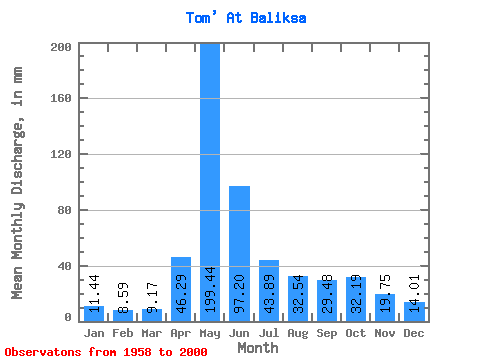
| Statistic | Jan | Feb | Mar | Apr | May | Jun | Jul | Aug | Sep | Oct | Nov | Dec | Annual |
|---|---|---|---|---|---|---|---|---|---|---|---|---|---|
| Mean | 11.44 | 8.67 | 9.17 | 46.29 | 199.41 | 97.20 | 43.88 | 32.54 | 29.48 | 32.19 | 19.75 | 14.01 | 542.22 |
| Standard Deviation | 2.96 | 1.92 | 1.72 | 26.57 | 51.71 | 50.80 | 17.80 | 11.55 | 11.58 | 14.67 | 6.88 | 4.16 | 96.28 |
| Min | 6.53 | 4.89 | 5.82 | 16.09 | 126.34 | 35.22 | 22.25 | 12.20 | 10.97 | 13.93 | 9.18 | 7.09 | 362.36 |
| Max | 19.44 | 14.37 | 13.28 | 146.32 | 325.03 | 286.37 | 99.02 | 71.16 | 71.80 | 84.55 | 38.15 | 24.19 | 761.98 |
| Coefficient of Variation | 0.26 | 0.22 | 0.19 | 0.57 | 0.26 | 0.52 | 0.41 | 0.35 | 0.39 | 0.46 | 0.35 | 0.30 | 0.18 |
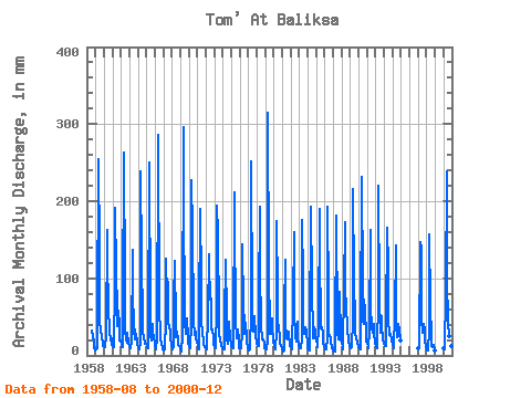
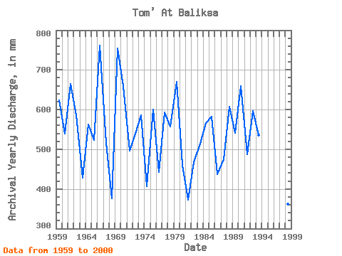
| Year | Jan | Feb | Mar | Apr | May | Jun | Jul | Aug | Sep | Oct | Nov | Dec | Annual | 1958 | 33.26 | 24.67 | 18.46 | 11.08 | 7.21 | 1959 | 7.72 | 7.61 | 9.28 | 44.31 | 263.48 | 135.87 | 48.48 | 30.67 | 28.64 | 21.38 | 17.77 | 12.74 | 624.80 | 1960 | 12.63 | 9.62 | 11.55 | 26.23 | 168.46 | 127.51 | 60.47 | 36.17 | 30.41 | 20.09 | 22.89 | 15.77 | 539.76 | 1961 | 11.12 | 9.60 | 11.23 | 90.41 | 197.61 | 109.74 | 59.50 | 39.85 | 57.59 | 40.17 | 19.75 | 19.87 | 664.46 | 1962 | 13.93 | 10.43 | 10.50 | 61.87 | 272.12 | 89.99 | 34.99 | 21.70 | 16.30 | 30.99 | 15.99 | 11.88 | 587.11 | 1963 | 12.20 | 8.53 | 11.23 | 16.09 | 141.46 | 87.17 | 33.58 | 21.70 | 34.39 | 24.94 | 22.05 | 15.98 | 427.66 | 1964 | 10.54 | 8.92 | 8.76 | 16.09 | 246.20 | 123.33 | 49.13 | 32.07 | 22.05 | 18.68 | 15.68 | 15.12 | 563.05 | 1965 | 13.17 | 10.53 | 10.26 | 22.79 | 258.08 | 53.30 | 26.13 | 19.98 | 40.76 | 33.69 | 21.74 | 17.17 | 523.67 | 1966 | 13.39 | 9.25 | 8.42 | 23.41 | 276.44 | 286.37 | 59.61 | 31.32 | 20.17 | 17.60 | 9.18 | 8.57 | 761.98 | 1967 | 6.53 | 6.83 | 8.01 | 46.30 | 129.58 | 74.31 | 99.02 | 43.30 | 37.21 | 31.86 | 23.20 | 12.31 | 515.72 | 1968 | 9.66 | 7.10 | 10.77 | 70.44 | 126.34 | 39.30 | 24.73 | 31.96 | 20.17 | 13.93 | 12.65 | 10.47 | 376.09 | 1969 | 7.62 | 6.17 | 5.90 | 25.29 | 305.59 | 214.26 | 43.09 | 28.51 | 31.98 | 49.89 | 22.79 | 17.06 | 754.74 | 1970 | 12.20 | 10.04 | 8.97 | 41.28 | 234.32 | 163.04 | 49.67 | 45.68 | 26.13 | 32.29 | 20.90 | 18.90 | 660.69 | 1971 | 12.74 | 8.12 | 7.92 | 49.23 | 196.53 | 91.77 | 46.87 | 30.02 | 19.75 | 15.44 | 11.18 | 9.35 | 496.35 | 1972 | 9.68 | 7.41 | 8.23 | 52.57 | 134.98 | 72.95 | 98.27 | 54.53 | 33.65 | 35.20 | 22.57 | 13.61 | 540.54 | 1973 | 11.66 | 8.99 | 9.60 | 60.31 | 200.85 | 156.77 | 50.10 | 31.96 | 17.56 | 16.74 | 13.38 | 9.89 | 586.23 | 1974 | 9.20 | 7.58 | 7.81 | 48.60 | 128.50 | 49.23 | 23.65 | 16.20 | 33.97 | 45.68 | 20.69 | 16.84 | 406.32 | 1975 | 12.42 | 9.77 | 9.54 | 16.51 | 219.21 | 180.81 | 44.49 | 24.51 | 22.47 | 34.88 | 18.71 | 9.92 | 601.13 | 1976 | 10.52 | 8.98 | 8.97 | 29.68 | 149.02 | 61.14 | 28.94 | 53.88 | 31.77 | 33.37 | 17.87 | 11.55 | 443.15 | 1977 | 7.08 | 5.85 | 8.25 | 56.96 | 260.24 | 66.79 | 33.80 | 32.40 | 31.67 | 51.94 | 25.08 | 17.39 | 593.18 | 1978 | 15.77 | 12.00 | 11.99 | 72.64 | 198.69 | 116.01 | 36.50 | 25.38 | 21.11 | 21.49 | 16.93 | 9.83 | 556.86 | 1979 | 10.32 | 7.54 | 7.79 | 18.71 | 325.03 | 107.65 | 35.96 | 28.40 | 28.64 | 49.67 | 38.15 | 17.93 | 670.68 | 1980 | 12.96 | 10.23 | 8.68 | 31.56 | 180.33 | 80.79 | 41.90 | 39.20 | 20.38 | 16.74 | 11.91 | 9.20 | 461.27 | 1981 | 7.95 | 4.89 | 6.62 | 58.63 | 127.42 | 43.27 | 22.25 | 20.95 | 23.83 | 31.75 | 12.54 | 14.69 | 373.04 | 1982 | 11.55 | 8.18 | 8.43 | 67.41 | 165.22 | 53.83 | 29.80 | 24.73 | 17.35 | 44.92 | 25.71 | 12.53 | 467.38 | 1983 | 10.63 | 8.44 | 9.15 | 22.05 | 181.41 | 99.50 | 45.03 | 29.05 | 28.74 | 37.69 | 31.15 | 14.79 | 515.07 | 1984 | 9.47 | 6.86 | 6.88 | 23.10 | 198.69 | 90.72 | 63.71 | 53.56 | 22.16 | 38.44 | 32.51 | 24.19 | 566.20 | 1985 | 19.44 | 14.37 | 11.55 | 37.52 | 196.53 | 128.56 | 47.62 | 36.93 | 36.06 | 28.62 | 15.26 | 12.31 | 582.74 | 1986 | 10.40 | 7.08 | 8.39 | 24.04 | 199.77 | 75.98 | 28.62 | 26.13 | 23.83 | 19.11 | 9.35 | 8.01 | 437.84 | 1987 | 7.07 | 5.29 | 5.82 | 20.48 | 187.89 | 35.22 | 32.50 | 21.06 | 36.69 | 84.55 | 22.26 | 20.73 | 475.22 | 1988 | 16.41 | 10.23 | 7.92 | 88.42 | 178.17 | 78.39 | 73.11 | 71.16 | 31.46 | 24.84 | 17.77 | 12.20 | 607.16 | 1989 | 9.63 | 8.37 | 11.55 | 44.52 | 222.45 | 96.89 | 47.62 | 28.40 | 22.05 | 23.22 | 17.04 | 13.28 | 541.94 | 1990 | 11.66 | 8.19 | 8.86 | 36.89 | 239.72 | 90.83 | 47.08 | 41.57 | 71.80 | 62.20 | 25.82 | 18.36 | 659.22 | 1991 | 16.52 | 10.92 | 9.88 | 31.98 | 168.46 | 64.17 | 36.93 | 30.77 | 30.41 | 42.55 | 30.10 | 16.74 | 486.81 | 1992 | 12.63 | 9.72 | 10.25 | 72.12 | 227.85 | 70.23 | 37.90 | 30.99 | 50.69 | 41.79 | 19.13 | 16.84 | 597.23 | 1993 | 15.66 | 11.81 | 13.28 | 43.69 | 171.69 | 113.92 | 48.38 | 27.54 | 25.40 | 28.94 | 19.96 | 18.57 | 536.92 | 1994 | 15.77 | 9.20 | 9.85 | 52.47 | 146.86 | 48.39 | 24.73 | 25.81 | 40.34 | 35.42 | 33.97 | 19.87 | 460.96 | 1997 | 9.91 | 8.46 | 10.44 | 146.32 | 142.54 | 45.88 | 30.13 | 41.68 | 36.69 | 37.58 | 19.44 | 11.23 | 539.52 | 1998 | 8.13 | 6.36 | 6.73 | 33.76 | 161.98 | 66.05 | 22.79 | 12.20 | 10.97 | 14.69 | 13.48 | 7.09 | 362.36 | 2000 | 10.25 | 8.61 | 8.54 | 80.48 | 247.28 | 100.86 | 44.27 | 26.24 | 19.13 | 16.09 | 12.23 | 10.28 | 581.54 |
|---|
 Return to R-Arctic Net Home Page