|
|
|||||||||||||||||
| Point ID: 6673 | Downloads | Plots | Site Data | Code: 10055 |
|
|
|||||||||||||||||
| Download | |
|---|---|
| Site Descriptor Information | Site Time Series Data |
| Link to all available data | |
|
|
| View: | Statistics | Time Series |
| Units: | m3/s |
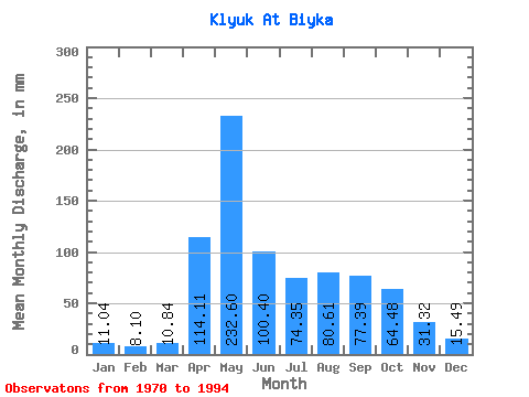
| Statistic | Jan | Feb | Mar | Apr | May | Jun | Jul | Aug | Sep | Oct | Nov | Dec | Annual |
|---|---|---|---|---|---|---|---|---|---|---|---|---|---|
| Mean | 11.05 | 8.16 | 10.83 | 114.11 | 232.55 | 100.40 | 74.34 | 80.60 | 77.37 | 64.48 | 31.33 | 15.47 | 821.69 |
| Standard Deviation | 7.11 | 6.96 | 9.89 | 57.82 | 114.98 | 57.66 | 60.30 | 56.12 | 44.88 | 30.83 | 11.45 | 7.92 | 188.55 |
| Min | 5.16 | 2.12 | 3.55 | 41.85 | 119.70 | 19.05 | 28.39 | 19.68 | 22.80 | 20.00 | 12.80 | 6.78 | 531.70 |
| Max | 34.52 | 32.63 | 42.27 | 242.02 | 587.22 | 273.25 | 329.10 | 271.03 | 179.25 | 146.48 | 56.21 | 43.23 | 1289.97 |
| Coefficient of Variation | 0.64 | 0.85 | 0.91 | 0.51 | 0.49 | 0.57 | 0.81 | 0.70 | 0.58 | 0.48 | 0.36 | 0.51 | 0.23 |
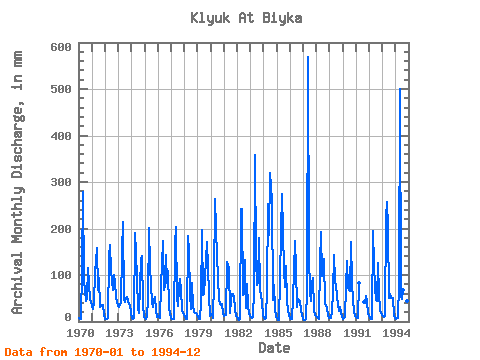
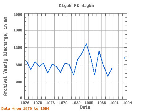
| Year | Jan | Feb | Mar | Apr | May | Jun | Jul | Aug | Sep | Oct | Nov | Dec | Annual | 1970 | 6.78 | 4.70 | 4.84 | 114.30 | 286.84 | 89.00 | 45.17 | 52.59 | 115.55 | 82.92 | 45.91 | 43.23 | 888.18 | 1971 | 34.52 | 25.87 | 42.27 | 104.62 | 162.62 | 67.77 | 96.15 | 32.91 | 36.23 | 33.88 | 36.23 | 17.42 | 688.55 | 1972 | 5.16 | 5.29 | 8.07 | 138.66 | 171.00 | 110.24 | 88.73 | 69.37 | 100.25 | 86.79 | 53.40 | 34.52 | 869.48 | 1973 | 31.94 | 32.63 | 40.33 | 148.65 | 221.66 | 45.28 | 42.27 | 51.95 | 53.40 | 39.69 | 36.23 | 18.71 | 761.43 | 1974 | 6.78 | 4.70 | 7.42 | 191.12 | 154.87 | 92.44 | 28.39 | 19.68 | 134.91 | 146.48 | 36.54 | 10.32 | 834.00 | 1975 | 8.39 | 5.59 | 11.29 | 48.72 | 208.75 | 119.61 | 41.30 | 32.91 | 43.41 | 55.17 | 24.36 | 10.32 | 607.12 | 1976 | 12.26 | 8.23 | 7.10 | 76.20 | 178.43 | 66.83 | 80.02 | 148.42 | 82.13 | 111.31 | 27.17 | 18.39 | 810.86 | 1977 | 8.71 | 5.88 | 5.49 | 166.14 | 210.05 | 50.90 | 33.56 | 76.47 | 92.12 | 70.98 | 24.05 | 15.49 | 757.63 | 1978 | 9.68 | 5.88 | 6.45 | 183.94 | 156.81 | 56.21 | 28.39 | 85.83 | 33.73 | 20.00 | 18.11 | 13.55 | 617.58 | 1979 | 11.29 | 4.70 | 5.49 | 41.85 | 203.59 | 57.46 | 60.34 | 98.41 | 170.51 | 120.35 | 56.21 | 12.26 | 838.43 | 1980 | 14.52 | 14.70 | 8.39 | 87.44 | 272.64 | 138.66 | 98.09 | 48.72 | 37.16 | 36.14 | 37.48 | 19.04 | 809.60 | 1981 | 12.58 | 12.35 | 14.52 | 128.35 | 119.70 | 19.05 | 46.78 | 60.01 | 58.71 | 54.53 | 27.79 | 11.62 | 564.66 | 1982 | 10.97 | 3.53 | 6.13 | 242.02 | 249.73 | 57.46 | 60.34 | 136.16 | 29.04 | 82.92 | 34.35 | 16.45 | 924.62 | 1983 | 9.68 | 7.94 | 10.97 | 64.96 | 371.05 | 133.35 | 80.02 | 86.47 | 179.25 | 71.63 | 41.85 | 14.20 | 1066.58 | 1984 | 8.07 | 4.41 | 8.71 | 68.70 | 260.38 | 185.81 | 329.10 | 271.03 | 46.53 | 80.98 | 29.36 | 9.03 | 1289.97 | 1985 | 7.10 | 3.82 | 3.55 | 88.38 | 200.37 | 273.25 | 115.51 | 77.11 | 119.61 | 44.85 | 25.61 | 11.94 | 970.57 | 1986 | 7.42 | 4.12 | 4.84 | 48.41 | 178.10 | 113.05 | 31.30 | 50.01 | 44.97 | 44.85 | 23.11 | 13.55 | 561.49 | 1987 | 6.45 | 2.12 | 5.81 | 65.89 | 587.22 | 142.09 | 62.27 | 45.82 | 81.51 | 97.76 | 24.05 | 14.84 | 1125.89 | 1988 | 10.32 | 7.35 | 5.16 | 125.85 | 199.72 | 98.06 | 118.41 | 137.77 | 37.16 | 31.94 | 12.80 | 8.71 | 788.68 | 1989 | 8.71 | 6.17 | 21.30 | 63.08 | 146.81 | 88.07 | 78.73 | 37.10 | 22.80 | 32.91 | 19.67 | 9.03 | 531.70 | 1990 | 5.49 | 7.05 | 9.03 | 73.70 | 133.90 | 71.83 | 67.76 | 177.13 | 85.25 | 44.85 | 22.80 | 12.91 | 707.88 | 1991 | 9.03 | 6.47 | 7.74 | 82.76 | 42.91 | 40.60 | 57.43 | 42.78 | 18.39 | 1992 | 12.58 | 5.00 | 6.13 | 194.56 | 124.87 | 74.64 | 48.72 | 45.82 | 125.23 | 60.01 | 25.61 | 14.20 | 738.30 | 1993 | 11.29 | 8.82 | 11.29 | 223.29 | 265.86 | 203.30 | 51.95 | 60.01 | 50.59 | 51.62 | 14.68 | 6.78 | 959.16 | 1994 | 6.45 | 6.76 | 8.39 | 81.19 | 516.24 | 55.27 | 50.98 | 70.34 | 113.67 | 51.95 | 43.10 | 11.94 | 1008.27 |
|---|
 Return to R-Arctic Net Home Page