|
|
|||||||||||||||||
| Point ID: 667 | Downloads | Plots | Site Data | Code: 07BF007 |
|
|
|||||||||||||||||
| Download | |
|---|---|
| Site Descriptor Information | Site Time Series Data |
| Link to all available data | |
|
|
| View: | Statistics | Time Series |
| Units: | m3/s |
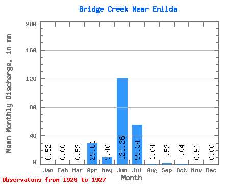
| Statistic | Jan | Feb | Mar | Apr | May | Jun | Jul | Aug | Sep | Oct | Nov | Dec | Annual |
|---|---|---|---|---|---|---|---|---|---|---|---|---|---|
| Mean | 0.52 | 0.00 | 0.52 | 29.81 | 9.40 | 121.26 | 55.34 | 1.04 | 1.52 | 0.78 | 0.25 | 0.00 | |
| Standard Deviation | 1.48 | 1.43 | 0.37 | 0.36 | |||||||||
| Min | 0.52 | 0.00 | 0.52 | 29.81 | 9.40 | 121.26 | 55.34 | 0.00 | 0.51 | 0.52 | 0.00 | 0.00 | |
| Max | 0.52 | 0.00 | 0.52 | 29.81 | 9.40 | 121.26 | 55.34 | 2.09 | 2.53 | 1.04 | 0.51 | 0.00 | |
| Coefficient of Variation | 1.41 | 0.94 | 0.47 | 1.41 |
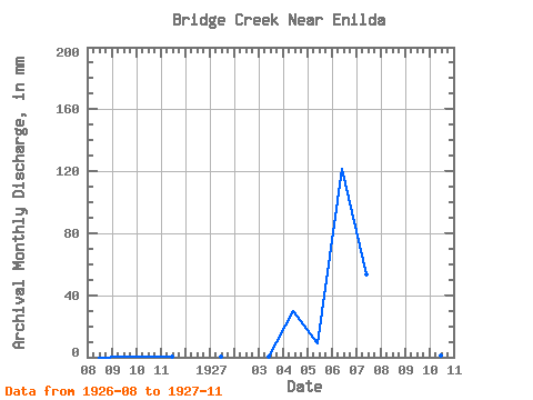
| Year | Jan | Feb | Mar | Apr | May | Jun | Jul | Aug | Sep | Oct | Nov | Dec | Annual | 1926 | 0.00 | 0.51 | 0.52 | 0.51 | 0.00 | 1927 | 0.52 | 0.00 | 0.52 | 29.81 | 9.40 | 121.26 | 55.34 | 2.09 | 2.53 | 1.04 | 0.00 |
|---|
 Return to R-Arctic Net Home Page