|
|
|||||||||||||||||
| Point ID: 6582 | Downloads | Plots | Site Data | Code: 9283 |
|
|
|||||||||||||||||
| Download | |
|---|---|
| Site Descriptor Information | Site Time Series Data |
| Link to all available data | |
|
|
| View: | Statistics | Time Series |
| Units: | m3/s |
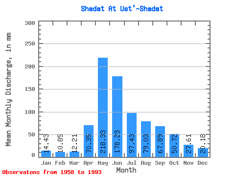
| Statistic | Jan | Feb | Mar | Apr | May | Jun | Jul | Aug | Sep | Oct | Nov | Dec | Annual |
|---|---|---|---|---|---|---|---|---|---|---|---|---|---|
| Mean | 14.43 | 10.95 | 12.21 | 70.34 | 218.30 | 178.23 | 97.42 | 79.02 | 67.89 | 50.72 | 27.61 | 20.17 | 845.40 |
| Standard Deviation | 2.99 | 2.20 | 2.85 | 25.84 | 55.58 | 77.52 | 42.35 | 34.91 | 24.41 | 17.32 | 9.21 | 10.85 | 149.45 |
| Min | 9.15 | 7.26 | 7.84 | 33.79 | 126.41 | 84.09 | 38.42 | 27.58 | 31.32 | 27.90 | 15.74 | 11.16 | 561.35 |
| Max | 23.59 | 16.12 | 19.45 | 149.81 | 339.53 | 408.86 | 243.89 | 159.41 | 144.72 | 111.74 | 63.87 | 76.83 | 1133.11 |
| Coefficient of Variation | 0.21 | 0.20 | 0.23 | 0.37 | 0.26 | 0.43 | 0.43 | 0.44 | 0.36 | 0.34 | 0.33 | 0.54 | 0.18 |
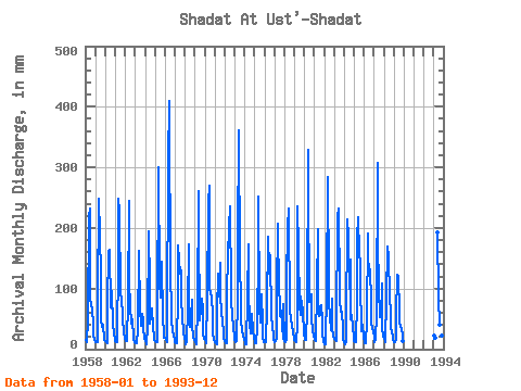
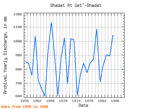
| Year | Jan | Feb | Mar | Apr | May | Jun | Jul | Aug | Sep | Oct | Nov | Dec | Annual | 1958 | 14.94 | 12.07 | 11.97 | 48.91 | 224.76 | 231.43 | 89.27 | 72.37 | 66.34 | 42.56 | 24.69 | 15.73 | 852.97 | 1959 | 11.91 | 10.44 | 11.48 | 81.15 | 256.64 | 186.69 | 127.20 | 51.33 | 35.95 | 41.76 | 15.74 | 15.30 | 841.85 | 1960 | 13.17 | 10.57 | 10.44 | 71.74 | 167.38 | 163.54 | 70.62 | 69.82 | 95.04 | 41.45 | 25.61 | 18.01 | 756.42 | 1961 | 13.87 | 10.89 | 12.85 | 149.81 | 256.64 | 226.80 | 92.77 | 88.15 | 86.25 | 54.20 | 25.77 | 19.29 | 1035.66 | 1962 | 14.04 | 12.08 | 14.73 | 77.30 | 251.86 | 110.16 | 74.28 | 42.72 | 44.74 | 51.81 | 17.59 | 12.37 | 720.01 | 1963 | 11.40 | 8.93 | 10.68 | 33.79 | 167.38 | 155.83 | 70.78 | 39.69 | 58.32 | 50.21 | 35.18 | 18.33 | 658.75 | 1964 | 15.54 | 7.54 | 8.02 | 36.57 | 200.85 | 104.61 | 43.20 | 55.15 | 66.65 | 36.82 | 20.67 | 15.72 | 608.55 | 1965 | 14.35 | 11.20 | 11.43 | 56.01 | 310.84 | 106.46 | 91.18 | 88.31 | 144.72 | 50.53 | 30.39 | 19.93 | 930.64 | 1966 | 19.45 | 13.74 | 12.67 | 44.43 | 318.81 | 408.86 | 107.28 | 89.58 | 49.22 | 31.24 | 21.91 | 17.85 | 1133.11 | 1967 | 11.13 | 9.38 | 10.86 | 90.26 | 176.94 | 146.11 | 128.96 | 134.06 | 77.45 | 57.86 | 25.15 | 22.00 | 886.14 | 1968 | 12.94 | 8.39 | 11.65 | 67.11 | 178.53 | 84.09 | 38.42 | 55.47 | 81.31 | 42.56 | 18.98 | 14.97 | 612.41 | 1969 | 13.44 | 11.72 | 8.38 | 71.28 | 269.39 | 200.57 | 49.41 | 69.34 | 83.62 | 67.59 | 23.76 | 18.01 | 884.12 | 1970 | 15.05 | 11.26 | 10.52 | 81.62 | 248.67 | 270.00 | 101.54 | 98.83 | 81.46 | 64.24 | 24.84 | 17.85 | 1023.49 | 1971 | 12.86 | 9.47 | 7.84 | 60.02 | 129.28 | 86.09 | 146.33 | 92.45 | 61.87 | 46.55 | 28.70 | 18.65 | 696.18 | 1972 | 13.05 | 8.64 | 10.74 | 92.42 | 157.65 | 200.57 | 243.89 | 101.22 | 78.84 | 58.02 | 35.95 | 20.40 | 1017.22 | 1973 | 16.10 | 11.66 | 13.26 | 80.85 | 181.72 | 361.03 | 147.29 | 80.34 | 46.44 | 33.00 | 23.14 | 16.58 | 1011.06 | 1974 | 11.99 | 7.26 | 8.45 | 83.31 | 178.53 | 101.21 | 43.52 | 27.58 | 44.90 | 59.94 | 30.70 | 18.65 | 614.17 | 1975 | 11.64 | 9.78 | 10.79 | 36.87 | 167.38 | 251.49 | 71.73 | 45.11 | 90.10 | 42.72 | 18.21 | 12.53 | 768.43 | 1976 | 13.68 | 10.91 | 11.13 | 69.58 | 191.29 | 131.91 | 128.80 | 159.41 | 52.92 | 41.45 | 20.52 | 15.38 | 841.79 | 1977 | 12.26 | 11.98 | 16.90 | 94.58 | 213.60 | 88.10 | 89.27 | 56.91 | 63.87 | 39.85 | 16.66 | 76.83 | 776.54 | 1978 | 13.87 | 11.76 | 17.22 | 111.55 | 205.63 | 231.43 | 59.62 | 59.14 | 49.99 | 40.65 | 27.31 | 18.17 | 845.98 | 1979 | 15.80 | 12.43 | 12.45 | 40.42 | 243.89 | 163.54 | 73.49 | 58.34 | 86.09 | 77.15 | 63.87 | 25.82 | 870.37 | 1980 | 18.33 | 15.11 | 15.06 | 67.27 | 339.53 | 268.46 | 79.70 | 87.35 | 91.03 | 54.36 | 30.09 | 22.80 | 1085.89 | 1981 | 18.01 | 13.58 | 13.58 | 99.21 | 204.04 | 88.41 | 56.75 | 58.34 | 73.29 | 51.01 | 26.38 | 11.16 | 711.62 | 1982 | 9.15 | 7.83 | 8.26 | 96.89 | 293.31 | 109.08 | 81.30 | 54.20 | 31.32 | 86.72 | 35.02 | 20.56 | 828.31 | 1983 | 16.90 | 14.13 | 14.70 | 37.65 | 224.76 | 231.43 | 104.09 | 85.12 | 61.41 | 64.08 | 34.10 | 17.69 | 903.04 | 1984 | 12.10 | 8.13 | 11.86 | 39.96 | 221.57 | 186.69 | 102.82 | 153.67 | 49.22 | 57.86 | 36.41 | 19.93 | 895.03 | 1985 | 14.79 | 11.21 | 11.16 | 81.31 | 188.10 | 217.54 | 164.19 | 147.29 | 112.47 | 31.08 | 39.96 | 21.36 | 1037.60 | 1986 | 11.70 | 8.63 | 10.27 | 47.83 | 197.66 | 130.22 | 145.85 | 129.44 | 86.25 | 45.91 | 35.49 | 30.29 | 874.35 | 1987 | 19.93 | 10.57 | 16.42 | 58.78 | 317.21 | 175.89 | 105.37 | 54.04 | 51.99 | 111.74 | 33.17 | 22.32 | 971.35 | 1988 | 16.90 | 13.54 | 11.57 | 85.32 | 175.34 | 150.58 | 133.10 | 113.18 | 36.26 | 27.90 | 20.98 | 17.38 | 798.52 | 1989 | 12.34 | 10.21 | 16.10 | 57.24 | 126.41 | 120.03 | 64.08 | 47.82 | 36.72 | 35.07 | 22.22 | 14.52 | 561.35 | 1993 | 23.59 | 16.12 | 19.45 | 192.86 | 88.79 | 41.76 | 64.18 | 35.71 | 22.06 | 19.29 |
|---|
 Return to R-Arctic Net Home Page