|
|
|||||||||||||||||
| Point ID: 628 | Downloads | Plots | Site Data | Code: 07AF909 |
|
|
|||||||||||||||||
| Download | |
|---|---|
| Site Descriptor Information | Site Time Series Data |
| Link to all available data | |
|
|
| View: | Statistics | Time Series |
| Units: | m3/s |
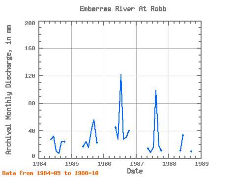
| Statistic | Jan | Feb | Mar | Apr | May | Jun | Jul | Aug | Sep | Oct | Nov | Dec | Annual |
|---|---|---|---|---|---|---|---|---|---|---|---|---|---|
| Mean | 23.47 | 25.22 | 35.95 | 38.52 | 27.53 | 21.77 | |||||||
| Standard Deviation | 14.19 | 10.06 | 50.30 | 38.08 | 17.36 | 13.05 | |||||||
| Min | 11.32 | 8.51 | 10.69 | 6.81 | 9.50 | 7.64 | |||||||
| Max | 46.38 | 33.51 | 125.84 | 101.89 | 55.21 | 40.93 | |||||||
| Coefficient of Variation | 0.60 | 0.40 | 1.40 | 0.99 | 0.63 | 0.60 |
| Year | Jan | Feb | Mar | Apr | May | Jun | Jul | Aug | Sep | Oct | Nov | Dec | Annual | 1984 | 27.65 | 32.24 | 10.69 | 6.81 | 24.23 | 25.04 | 1985 | 17.46 | 24.02 | 15.72 | 42.67 | 55.21 | 23.51 | 1986 | 46.38 | 27.82 | 125.84 | 28.30 | 30.77 | 40.93 | 1987 | 14.52 | 8.51 | 15.68 | 101.89 | 17.91 | 11.71 | 1988 | 11.32 | 33.51 | 11.80 | 12.91 | 9.50 | 7.64 |
|---|
 Return to R-Arctic Net Home Page
