|
|
|||||||||||||||||
| Point ID: 626 | Downloads | Plots | Site Data | Code: 07AF906 |
|
|
|||||||||||||||||
| Download | |
|---|---|
| Site Descriptor Information | Site Time Series Data |
| Link to all available data | |
|
|
| View: | Statistics | Time Series |
| Units: | m3/s |
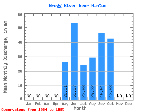
| Statistic | Jan | Feb | Mar | Apr | May | Jun | Jul | Aug | Sep | Oct | Nov | Dec | Annual |
|---|---|---|---|---|---|---|---|---|---|---|---|---|---|
| Mean | 26.30 | 53.37 | 23.87 | 29.32 | 46.64 | 42.52 | |||||||
| Standard Deviation | 2.44 | 12.13 | 5.67 | 29.08 | 17.52 | 22.16 | |||||||
| Min | 24.57 | 44.79 | 19.86 | 8.76 | 34.25 | 26.85 | |||||||
| Max | 28.03 | 61.95 | 27.88 | 49.88 | 59.03 | 58.20 | |||||||
| Coefficient of Variation | 0.09 | 0.23 | 0.24 | 0.99 | 0.38 | 0.52 |
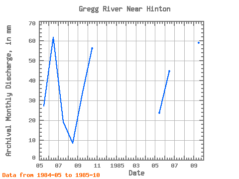
| Year | Jan | Feb | Mar | Apr | May | Jun | Jul | Aug | Sep | Oct | Nov | Dec | Annual | 1984 | 28.03 | 61.95 | 19.86 | 8.76 | 34.25 | 58.20 | 1985 | 24.57 | 44.79 | 27.88 | 49.88 | 59.03 | 26.85 |
|---|
 Return to R-Arctic Net Home Page