|
|
|||||||||||||||||
| Point ID: 6173 | Downloads | Plots | Site Data | Other Close Sites | Code: 3101 |
|
|
|||||||||||||||||
| Download | |
|---|---|
| Site Descriptor Information | Site Time Series Data |
| Link to all available data | |
|
|
| View: | Statistics | Time Series |
| Units: | m3/s |
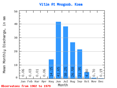
| Statistic | Jan | Feb | Mar | Apr | May | Jun | Jul | Aug | Sep | Oct | Nov | Dec | Annual |
|---|---|---|---|---|---|---|---|---|---|---|---|---|---|
| Mean | 0.06 | 0.03 | 0.01 | 0.06 | 14.15 | 41.65 | 38.25 | 26.57 | 21.35 | 4.79 | 0.70 | 0.19 | 137.21 |
| Standard Deviation | 0.03 | 0.02 | 0.01 | 0.03 | 4.23 | 19.48 | 21.71 | 14.25 | 10.50 | 1.28 | 0.23 | 0.10 | 13.17 |
| Min | 0.03 | 0.00 | 0.00 | 0.03 | 8.73 | 12.45 | 12.50 | 11.08 | 12.55 | 3.30 | 0.45 | 0.00 | 121.56 |
| Max | 0.10 | 0.06 | 0.03 | 0.10 | 18.13 | 69.30 | 84.89 | 58.48 | 45.49 | 6.81 | 1.02 | 0.28 | 157.49 |
| Coefficient of Variation | 0.40 | 0.76 | 0.84 | 0.47 | 0.30 | 0.47 | 0.57 | 0.54 | 0.49 | 0.27 | 0.33 | 0.56 | 0.10 |
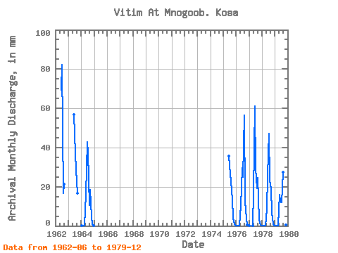
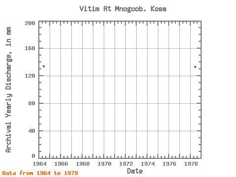
| Year | Jan | Feb | Mar | Apr | May | Jun | Jul | Aug | Sep | Oct | Nov | Dec | Annual | 1962 | 69.30 | 84.89 | 17.16 | 21.16 | 1963 | 56.78 | 38.26 | 29.88 | 16.66 | 1964 | 0.07 | 0.06 | 0.03 | 0.06 | 16.85 | 42.67 | 38.62 | 11.08 | 18.34 | 5.08 | 0.73 | 0.28 | 133.49 | 1975 | 35.62 | 27.14 | 23.68 | 13.38 | 4.34 | 0.93 | 0.27 | 1976 | 0.10 | 0.03 | 0.01 | 0.05 | 10.49 | 29.62 | 25.69 | 58.48 | 12.55 | 3.73 | 0.50 | 0.00 | 140.13 | 1977 | 0.03 | 0.00 | 0.00 | 0.04 | 18.13 | 61.01 | 30.06 | 19.86 | 24.51 | 3.30 | 0.45 | 0.13 | 157.49 | 1978 | 0.07 | 0.03 | 0.02 | 0.10 | 8.73 | 25.74 | 48.82 | 24.05 | 18.69 | 6.81 | 1.02 | 0.20 | 133.36 | 1979 | 0.05 | 0.01 | 0.01 | 0.03 | 16.54 | 12.45 | 12.50 | 28.42 | 45.49 | 5.50 | 0.60 | 0.24 | 121.56 |
|---|
| Other Close Sites | ||||||
|---|---|---|---|---|---|---|
| PointID | Latitude | Longitude | Drainage Area | Source | Name | |
| 6174 | "Vitim At Spitsino" | 56.22 | 1607210 | SHI | 743.00 | |
 Return to R-Arctic Net Home Page