|
|
|||||||||||||||||
| Point ID: 6071 | Downloads | Plots | Site Data | Code: 7184 |
|
|
|||||||||||||||||
| Download | |
|---|---|
| Site Descriptor Information | Site Time Series Data |
| Link to all available data | |
|
|
| View: | Statistics | Time Series |
| Units: | m3/s |
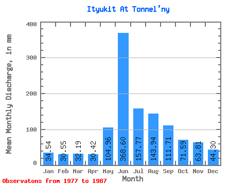
| Statistic | Jan | Feb | Mar | Apr | May | Jun | Jul | Aug | Sep | Oct | Nov | Dec | Annual |
|---|---|---|---|---|---|---|---|---|---|---|---|---|---|
| Mean | 34.52 | 30.82 | 32.19 | 30.42 | 104.94 | 368.60 | 157.75 | 143.92 | 111.71 | 71.58 | 63.80 | 44.31 | 1199.70 |
| Standard Deviation | 14.51 | 7.02 | 8.49 | 6.57 | 67.82 | 117.27 | 88.77 | 84.64 | 47.23 | 20.11 | 47.59 | 9.95 | 240.78 |
| Min | 3.23 | 17.57 | 17.60 | 17.85 | 33.53 | 212.55 | 42.75 | 37.30 | 54.35 | 40.23 | 34.88 | 24.31 | 721.91 |
| Max | 54.06 | 43.15 | 48.20 | 38.53 | 238.46 | 571.94 | 306.78 | 315.16 | 194.30 | 96.81 | 203.63 | 60.35 | 1625.33 |
| Coefficient of Variation | 0.42 | 0.23 | 0.26 | 0.22 | 0.65 | 0.32 | 0.56 | 0.59 | 0.42 | 0.28 | 0.75 | 0.22 | 0.20 |
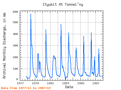
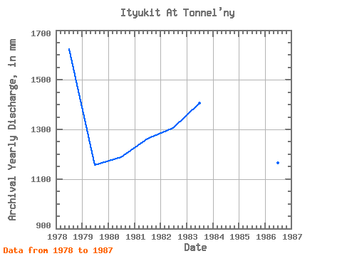
| Year | Jan | Feb | Mar | Apr | May | Jun | Jul | Aug | Sep | Oct | Nov | Dec | Annual | 1977 | 34.88 | 24.31 | 1978 | 20.12 | 17.57 | 17.60 | 17.85 | 40.65 | 571.94 | 306.78 | 315.16 | 126.56 | 86.33 | 56.38 | 50.71 | 1625.33 | 1979 | 45.26 | 32.08 | 25.98 | 26.37 | 238.46 | 229.18 | 71.67 | 170.57 | 141.97 | 88.43 | 48.27 | 41.49 | 1156.54 | 1980 | 33.95 | 29.78 | 33.11 | 25.96 | 33.53 | 438.08 | 209.13 | 135.79 | 88.83 | 74.18 | 49.89 | 36.04 | 1189.47 | 1981 | 30.59 | 23.67 | 23.47 | 29.61 | 161.77 | 212.55 | 215.83 | 189.85 | 194.30 | 96.81 | 47.46 | 42.75 | 1263.96 | 1982 | 44.01 | 36.66 | 34.37 | 31.64 | 71.67 | 482.70 | 167.64 | 113.57 | 118.85 | 80.89 | 71.39 | 50.71 | 1307.18 | 1983 | 3.23 | 27.49 | 30.18 | 25.55 | 73.34 | 409.69 | 235.53 | 230.92 | 169.96 | 87.59 | 62.06 | 54.06 | 1408.72 | 1984 | 54.06 | 43.15 | 38.14 | 36.91 | 186.08 | 281.51 | 185.24 | 106.45 | 93.70 | 64.12 | 49.49 | 42.75 | 1179.59 | 1985 | 37.72 | 31.31 | 48.20 | 38.53 | 73.76 | 380.49 | 82.98 | 68.31 | 68.55 | 54.06 | 42.59 | 47.78 | 977.09 | 1986 | 44.01 | 34.75 | 35.20 | 36.51 | 103.10 | 409.69 | 59.93 | 71.25 | 60.03 | 43.17 | 203.63 | 60.35 | 1167.24 | 1987 | 32.27 | 31.69 | 35.62 | 35.29 | 67.06 | 270.15 | 42.75 | 37.30 | 54.35 | 40.23 | 35.70 | 36.46 | 721.91 |
|---|
 Return to R-Arctic Net Home Page