|
|
|||||||||||||||||
| Point ID: 6068 | Downloads | Plots | Site Data | Code: 7176 |
|
|
|||||||||||||||||
| Download | |
|---|---|
| Site Descriptor Information | Site Time Series Data |
| Link to all available data | |
|
|
| View: | Statistics | Time Series |
| Units: | m3/s |
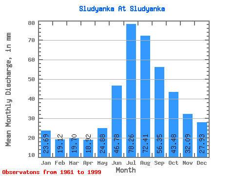
| Statistic | Jan | Feb | Mar | Apr | May | Jun | Jul | Aug | Sep | Oct | Nov | Dec | Annual |
|---|---|---|---|---|---|---|---|---|---|---|---|---|---|
| Mean | 23.71 | 19.29 | 19.68 | 18.93 | 24.87 | 46.76 | 78.24 | 72.37 | 56.36 | 43.49 | 32.07 | 27.92 | 462.26 |
| Standard Deviation | 9.99 | 7.96 | 8.33 | 7.77 | 10.21 | 29.30 | 56.97 | 40.30 | 31.20 | 21.21 | 13.42 | 11.19 | 157.01 |
| Min | 8.56 | 7.80 | 8.56 | 6.91 | 8.56 | 9.67 | 5.23 | 11.42 | 19.80 | 16.65 | 12.89 | 11.89 | 191.06 |
| Max | 49.47 | 37.27 | 38.05 | 36.83 | 48.04 | 174.95 | 309.66 | 211.67 | 145.02 | 89.42 | 57.09 | 53.27 | 767.51 |
| Coefficient of Variation | 0.42 | 0.41 | 0.42 | 0.41 | 0.41 | 0.63 | 0.73 | 0.56 | 0.55 | 0.49 | 0.42 | 0.40 | 0.34 |
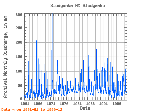
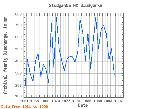
| Year | Jan | Feb | Mar | Apr | May | Jun | Jul | Aug | Sep | Oct | Nov | Dec | Annual | 1961 | 15.70 | 12.13 | 15.70 | 14.73 | 15.22 | 9.67 | 13.32 | 11.42 | 20.72 | 19.98 | 21.64 | 20.93 | 191.06 | 1962 | 15.70 | 14.30 | 11.89 | 6.91 | 48.04 | 78.27 | 136.99 | 38.53 | 19.80 | 16.65 | 12.89 | 15.70 | 413.42 | 1963 | 11.42 | 9.10 | 9.51 | 9.21 | 9.51 | 17.50 | 61.36 | 36.15 | 70.90 | 32.82 | 15.19 | 11.89 | 293.83 | 1964 | 8.56 | 7.80 | 9.99 | 19.34 | 32.34 | 24.86 | 24.26 | 24.26 | 32.69 | 21.88 | 14.27 | 11.89 | 231.70 | 1965 | 10.46 | 8.23 | 8.56 | 9.67 | 23.31 | 17.03 | 29.49 | 211.67 | 27.62 | 26.16 | 21.18 | 17.12 | 406.41 | 1966 | 13.32 | 10.40 | 10.46 | 10.59 | 16.65 | 50.18 | 146.98 | 104.65 | 42.36 | 29.49 | 19.34 | 15.70 | 466.67 | 1967 | 13.79 | 10.40 | 11.42 | 9.21 | 9.51 | 23.94 | 5.23 | 107.50 | 31.77 | 20.93 | 17.03 | 14.75 | 274.21 | 1968 | 14.27 | 10.84 | 9.04 | 9.21 | 15.22 | 24.86 | 127.48 | 63.74 | 46.96 | 26.16 | 16.11 | 11.89 | 373.25 | 1969 | 9.04 | 8.67 | 9.04 | 7.83 | 13.79 | 17.03 | 68.02 | 101.79 | 45.12 | 22.36 | 18.88 | 16.65 | 335.87 | 1970 | 16.17 | 13.00 | 10.94 | 10.13 | 18.07 | 29.93 | 19.03 | 15.70 | 37.29 | 20.45 | 16.57 | 15.70 | 223.29 | 1971 | 16.65 | 13.00 | 13.32 | 29.00 | 18.07 | 46.96 | 309.66 | 68.50 | 67.22 | 57.56 | 39.13 | 37.10 | 710.52 | 1972 | 35.20 | 29.47 | 28.54 | 23.02 | 22.83 | 26.24 | 37.10 | 33.30 | 33.61 | 28.54 | 26.24 | 24.26 | 348.49 | 1973 | 22.83 | 19.94 | 22.36 | 22.10 | 35.20 | 92.08 | 140.80 | 131.28 | 105.89 | 73.73 | 57.09 | 47.09 | 767.51 | 1974 | 38.53 | 25.57 | 23.31 | 22.56 | 39.01 | 81.03 | 43.76 | 49.95 | 52.95 | 54.70 | 32.69 | 32.34 | 496.10 | 1975 | 19.03 | 16.04 | 17.60 | 15.19 | 25.69 | 51.10 | 75.63 | 49.47 | 50.64 | 48.99 | 20.72 | 18.55 | 407.35 | 1976 | 17.60 | 15.17 | 16.17 | 15.65 | 18.07 | 18.88 | 48.99 | 52.32 | 31.31 | 37.10 | 29.00 | 23.78 | 322.79 | 1977 | 21.41 | 17.34 | 19.03 | 21.18 | 24.26 | 64.92 | 63.74 | 43.29 | 39.13 | 39.01 | 34.07 | 30.44 | 417.16 | 1978 | 27.59 | 23.84 | 25.69 | 23.94 | 25.69 | 48.34 | 68.50 | 45.66 | 46.04 | 40.43 | 34.07 | 32.82 | 441.92 | 1979 | 31.39 | 27.74 | 29.49 | 28.54 | 39.48 | 38.67 | 51.37 | 43.29 | 41.44 | 38.53 | 34.99 | 33.77 | 438.18 | 1980 | 28.54 | 26.00 | 27.11 | 25.78 | 28.06 | 73.20 | 38.05 | 33.30 | 29.46 | 28.06 | 27.62 | 26.64 | 392.40 | 1981 | 26.16 | 23.84 | 26.16 | 23.94 | 25.21 | 37.29 | 56.60 | 49.95 | 61.69 | 56.60 | 44.20 | 38.05 | 469.01 | 1982 | 37.58 | 29.90 | 30.44 | 27.62 | 36.15 | 54.79 | 136.04 | 116.54 | 101.75 | 72.78 | 55.25 | 49.47 | 745.56 | 1983 | 45.19 | 36.84 | 38.05 | 36.83 | 38.53 | 63.53 | 140.32 | 68.50 | 55.25 | 41.86 | 40.98 | 34.72 | 639.05 | 1984 | 31.87 | 26.00 | 27.59 | 26.24 | 27.59 | 28.54 | 33.30 | 50.90 | 43.74 | 35.20 | 34.99 | 34.25 | 399.87 | 1985 | 30.44 | 27.74 | 28.54 | 28.54 | 39.96 | 74.58 | 159.35 | 82.77 | 65.38 | 47.09 | 31.77 | 29.97 | 643.72 | 1986 | 26.16 | 21.24 | 20.45 | 17.95 | 25.21 | 40.98 | 64.69 | 32.82 | 25.32 | 22.83 | 21.64 | 19.50 | 338.21 | 1987 | 19.50 | 16.47 | 17.60 | 17.03 | 18.07 | 43.28 | 53.27 | 104.65 | 103.59 | 75.16 | 57.09 | 53.27 | 577.38 | 1988 | 49.47 | 37.27 | 35.20 | 34.07 | 44.24 | 174.95 | 74.68 | 71.35 | 105.43 | 58.03 | 44.66 | 35.67 | 766.58 | 1989 | 32.34 | 25.57 | 27.11 | 25.32 | 25.69 | 26.70 | 50.42 | 93.71 | 64.92 | 51.85 | 42.36 | 39.01 | 503.58 | 1990 | 28.54 | 21.67 | 23.78 | 23.02 | 35.20 | 28.08 | 101.79 | 111.78 | 113.72 | 89.42 | 50.64 | 39.48 | 664.27 | 1991 | 32.82 | 23.40 | 22.83 | 21.64 | 26.16 | 55.25 | 111.31 | 111.78 | 128.91 | 82.29 | 46.04 | 36.63 | 696.97 | 1992 | 29.49 | 22.10 | 22.83 | 21.18 | 33.30 | 39.59 | 35.67 | 103.69 | 145.02 | 81.81 | 49.72 | 41.38 | 625.03 | 1993 | 27.11 | 20.37 | 20.45 | 17.03 | 19.50 | 26.24 | 40.43 | 133.66 | 32.23 | 31.39 | 24.86 | 19.98 | 411.08 | 1994 | 17.60 | 13.87 | 11.42 | 9.67 | 9.99 | 54.79 | 117.97 | 65.17 | 49.26 | 74.68 | 48.34 | 31.87 | 502.18 | 1995 | 17.60 | 12.13 | 9.51 | 8.29 | 8.56 | 61.69 | 26.64 | 26.64 | 34.53 | 32.82 | 29.00 | 25.69 | 293.36 | 1996 | 19.03 | 15.60 | 11.89 | 13.35 | 16.17 | 32.69 | 88.00 | 93.23 | 38.67 | 20.45 | 19.34 | 17.60 | 383.99 | 1997 | 16.17 | 13.87 | 15.22 | 13.81 | 15.70 | 43.74 | 39.48 | 67.07 | 41.90 | 33.30 | 22.56 | 19.50 | 341.48 | 1998 | 17.12 | 14.73 | 15.70 | 16.11 | 20.93 | 66.30 | 101.79 | 79.44 | 67.68 | 77.06 | 53.41 | 41.38 | 569.44 | 1999 | 33.30 | 30.77 | 33.77 | 23.02 | 25.69 | 35.91 | 109.88 | 93.23 | 46.04 | 28.06 | 25.32 | 22.36 | 505.45 |
|---|
 Return to R-Arctic Net Home Page