|
|
|||||||||||||||||
| Point ID: 5308 | Downloads | Plots | Site Data | Code: 05HF004 |
|
|
|||||||||||||||||
| Download | |
|---|---|
| Site Descriptor Information | Site Time Series Data |
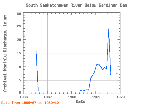
| Link to all available data | |
|
|
| View: | Statistics | Time Series |
| Units: | m3/s |
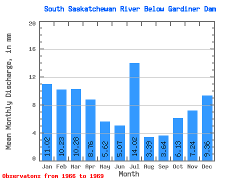
| Statistic | Jan | Feb | Mar | Apr | May | Jun | Jul | Aug | Sep | Oct | Nov | Dec | Annual |
|---|---|---|---|---|---|---|---|---|---|---|---|---|---|
| Mean | 7.05 | 6.60 | 6.58 | 5.60 | 3.59 | 3.24 | 8.96 | 2.17 | 2.33 | 3.92 | 4.63 | 5.99 | 77.70 |
| Standard Deviation | 4.05 | 3.64 | 7.58 | 2.17 | 2.07 | 0.11 | 0.32 | 0.81 | |||||
| Min | 7.05 | 6.60 | 6.58 | 5.60 | 0.73 | 0.67 | 0.82 | 0.88 | 0.86 | 3.84 | 4.40 | 5.42 | 77.70 |
| Max | 7.05 | 6.60 | 6.58 | 5.60 | 6.46 | 5.81 | 15.83 | 4.67 | 3.79 | 4.00 | 4.86 | 6.56 | 77.70 |
| Coefficient of Variation | 1.13 | 1.12 | 0.85 | 1.00 | 0.89 | 0.03 | 0.07 | 0.14 |
| Year | Jan | Feb | Mar | Apr | May | Jun | Jul | Aug | Sep | Oct | Nov | Dec | Annual | 1966 | 10.24 | 0.88 | 1968 | 0.73 | 0.67 | 0.82 | 0.95 | 0.86 | 3.84 | 4.40 | 5.42 | 1969 | 7.05 | 6.60 | 6.58 | 5.60 | 6.46 | 5.81 | 15.83 | 4.67 | 3.79 | 4.00 | 4.86 | 6.56 | 77.70 |
|---|
 Return to R-Arctic Net Home Page