|
|
|||||||||||||||||
| Point ID: 5289 | Downloads | Plots | Site Data | Code: 05HD006 |
|
|
|||||||||||||||||
| Download | |
|---|---|
| Site Descriptor Information | Site Time Series Data |
| Link to all available data | |
|
|
| View: | Statistics | Time Series |
| Units: | m3/s |
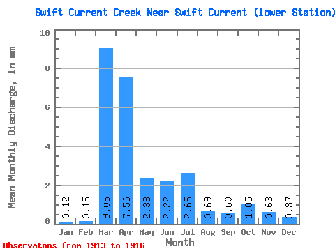
| Statistic | Jan | Feb | Mar | Apr | May | Jun | Jul | Aug | Sep | Oct | Nov | Dec | Annual |
|---|---|---|---|---|---|---|---|---|---|---|---|---|---|
| Mean | 0.09 | 0.11 | 6.50 | 5.43 | 1.71 | 1.60 | 1.90 | 0.50 | 0.43 | 0.76 | 0.45 | 0.26 | 20.21 |
| Standard Deviation | 0.04 | 0.10 | 6.80 | 0.38 | 0.75 | 0.76 | 1.79 | 0.46 | 0.18 | 0.29 | 0.07 | 0.01 | 11.33 |
| Min | 0.04 | 0.04 | 2.38 | 5.18 | 0.97 | 0.67 | 0.15 | 0.02 | 0.17 | 0.39 | 0.38 | 0.25 | 11.51 |
| Max | 0.12 | 0.22 | 14.34 | 5.87 | 2.46 | 2.53 | 4.34 | 1.08 | 0.61 | 1.09 | 0.49 | 0.28 | 33.02 |
| Coefficient of Variation | 0.47 | 0.88 | 1.05 | 0.07 | 0.44 | 0.48 | 0.94 | 0.92 | 0.43 | 0.38 | 0.15 | 0.05 | 0.56 |
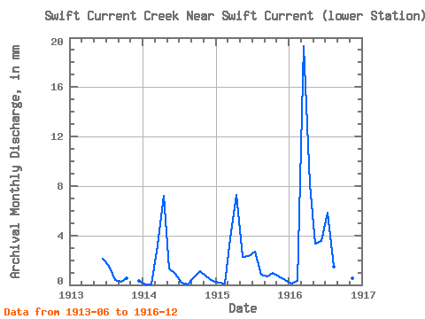
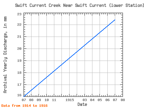
| Year | Jan | Feb | Mar | Apr | May | Jun | Jul | Aug | Sep | Oct | Nov | Dec | Annual | 1913 | 1.52 | 1.14 | 0.28 | 0.17 | 0.39 | 0.25 | 1914 | 0.04 | 0.04 | 2.38 | 5.18 | 0.97 | 0.67 | 0.15 | 0.02 | 0.46 | 0.83 | 0.49 | 0.25 | 11.51 | 1915 | 0.12 | 0.07 | 2.77 | 5.25 | 1.69 | 1.66 | 1.99 | 0.62 | 0.47 | 0.72 | 0.49 | 0.27 | 16.09 | 1916 | 0.10 | 0.22 | 14.34 | 5.87 | 2.46 | 2.53 | 4.34 | 1.08 | 0.61 | 1.09 | 0.38 | 0.28 | 33.02 |
|---|
 Return to R-Arctic Net Home Page