|
|
|||||||||||||||||
| Point ID: 5286 | Downloads | Plots | Site Data | Code: 05HD003 |
|
|
|||||||||||||||||
| Download | |
|---|---|
| Site Descriptor Information | Site Time Series Data |
| Link to all available data | |
|
|
| View: | Statistics | Time Series |
| Units: | m3/s |
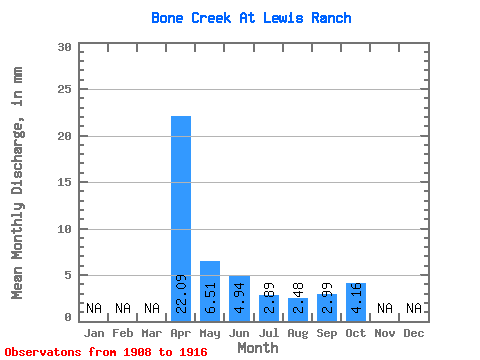
| Statistic | Jan | Feb | Mar | Apr | May | Jun | Jul | Aug | Sep | Oct | Nov | Dec | Annual |
|---|---|---|---|---|---|---|---|---|---|---|---|---|---|
| Mean | 22.09 | 6.53 | 4.97 | 2.87 | 2.51 | 3.00 | 4.14 | ||||||
| Standard Deviation | 21.13 | 2.99 | 2.92 | 1.09 | 0.85 | 0.74 | 3.11 | ||||||
| Min | 4.61 | 3.96 | 2.40 | 1.01 | 1.07 | 2.14 | 2.75 | ||||||
| Max | 64.64 | 11.68 | 11.89 | 4.90 | 4.09 | 4.61 | 12.35 | ||||||
| Coefficient of Variation | 0.96 | 0.46 | 0.59 | 0.38 | 0.34 | 0.25 | 0.75 |
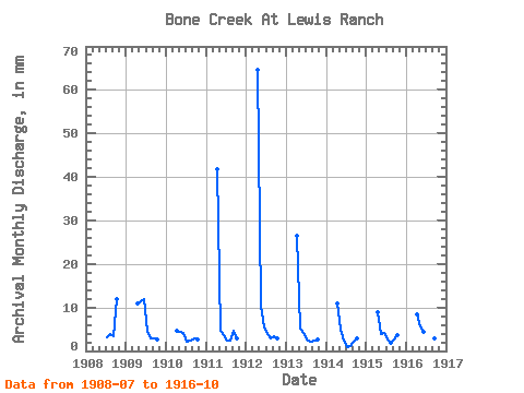
| Year | Jan | Feb | Mar | Apr | May | Jun | Jul | Aug | Sep | Oct | Nov | Dec | Annual | 1908 | 3.22 | 4.09 | 3.38 | 12.35 | 1909 | 10.91 | 11.68 | 11.89 | 4.90 | 2.89 | 2.86 | 2.82 | 1910 | 4.61 | 4.63 | 4.03 | 2.21 | 2.55 | 2.79 | 2.82 | 1911 | 41.71 | 4.76 | 3.57 | 2.48 | 2.42 | 4.61 | 2.95 | 1912 | 64.64 | 10.87 | 5.46 | 3.89 | 3.02 | 3.38 | 2.95 | 1913 | 26.50 | 5.37 | 4.03 | 2.62 | 2.15 | 2.34 | 2.75 | 1914 | 10.85 | 5.17 | 2.40 | 1.01 | 1.07 | 2.14 | 2.95 | 1915 | 9.03 | 3.96 | 4.03 | 2.82 | 1.68 | 2.53 | 3.76 | 1916 | 8.51 | 5.77 | 4.35 | 2.69 | 2.69 | 2.92 | 3.89 |
|---|
 Return to R-Arctic Net Home Page