|
|
|||||||||||||||||
| Point ID: 5238 | Downloads | Plots | Site Data | Code: 05HA013 |
|
|
|||||||||||||||||
| Download | |
|---|---|
| Site Descriptor Information | Site Time Series Data |
| Link to all available data | |
|
|
| View: | Statistics | Time Series |
| Units: | m3/s |
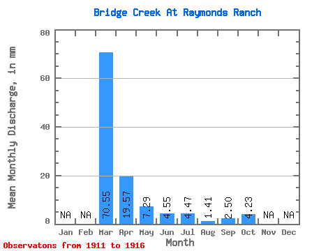
| Statistic | Jan | Feb | Mar | Apr | May | Jun | Jul | Aug | Sep | Oct | Nov | Dec | Annual |
|---|---|---|---|---|---|---|---|---|---|---|---|---|---|
| Mean | 70.54 | 19.62 | 7.25 | 4.48 | 4.47 | 1.41 | 2.50 | 4.14 | |||||
| Standard Deviation | 7.87 | 6.68 | 4.29 | 7.53 | 1.03 | 1.12 | 2.35 | ||||||
| Min | 70.54 | 9.79 | 1.18 | 0.46 | 0.00 | 0.23 | 0.91 | 1.18 | |||||
| Max | 70.54 | 30.72 | 18.34 | 12.06 | 19.75 | 3.06 | 4.10 | 7.05 | |||||
| Coefficient of Variation | 0.40 | 0.92 | 0.96 | 1.69 | 0.73 | 0.45 | 0.57 |
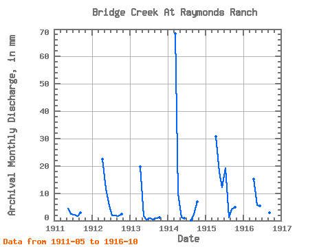
| Year | Jan | Feb | Mar | Apr | May | Jun | Jul | Aug | Sep | Oct | Nov | Dec | Annual | 1911 | 4.47 | 2.50 | 2.12 | 1.65 | 2.96 | 1912 | 22.53 | 11.99 | 5.46 | 1.88 | 1.88 | 1.59 | 2.35 | 1913 | 19.80 | 1.65 | 0.46 | 0.94 | 0.47 | 0.91 | 1.18 | 1914 | 70.54 | 9.79 | 1.18 | 0.91 | 0.00 | 0.23 | 2.50 | 7.05 | 1915 | 30.72 | 18.34 | 12.06 | 19.75 | 1.18 | 4.10 | 5.17 | 1916 | 15.25 | 5.88 | 5.46 | 2.12 | 3.06 | 2.96 | 4.94 |
|---|
 Return to R-Arctic Net Home Page