|
|
|||||||||||||||||
| Point ID: 5149 | Downloads | Plots | Site Data | Code: 03FC001 |
|
|
|||||||||||||||||
| Download | |
|---|---|
| Site Descriptor Information | Site Time Series Data |
| Link to all available data | |
|
|
| View: | Statistics | Time Series |
| Units: | m3/s |
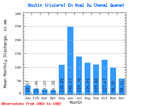
| Statistic | Jan | Feb | Mar | Apr | May | Jun | Jul | Aug | Sep | Oct | Nov | Dec | Annual |
|---|---|---|---|---|---|---|---|---|---|---|---|---|---|
| Mean | 33.57 | 21.64 | 18.99 | 16.38 | 108.83 | 248.07 | 139.74 | 116.79 | 109.88 | 127.65 | 98.33 | 58.10 | 1086.52 |
| Standard Deviation | 6.80 | 3.92 | 4.07 | 2.94 | 50.13 | 91.03 | 55.38 | 56.82 | 42.80 | 45.08 | 28.61 | 13.15 | 164.46 |
| Min | 20.61 | 14.38 | 11.19 | 11.19 | 37.57 | 89.51 | 62.42 | 43.93 | 46.06 | 63.00 | 55.01 | 36.22 | 845.82 |
| Max | 43.54 | 29.84 | 28.32 | 21.63 | 198.44 | 423.30 | 288.99 | 258.17 | 179.57 | 227.34 | 165.40 | 80.34 | 1420.90 |
| Coefficient of Variation | 0.20 | 0.18 | 0.21 | 0.18 | 0.46 | 0.37 | 0.40 | 0.49 | 0.39 | 0.35 | 0.29 | 0.23 | 0.15 |
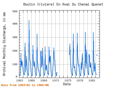
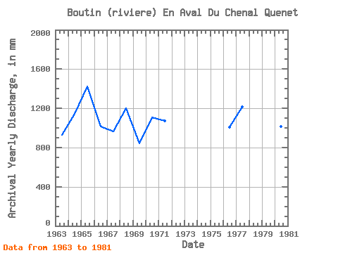
| Year | Jan | Feb | Mar | Apr | May | Jun | Jul | Aug | Sep | Oct | Nov | Dec | Annual | 1963 | 22.93 | 17.33 | 15.95 | 14.43 | 96.72 | 179.76 | 86.89 | 101.92 | 124.19 | 118.29 | 89.32 | 66.08 | 932.02 | 1964 | 39.11 | 25.10 | 22.73 | 19.95 | 139.87 | 257.33 | 130.24 | 43.93 | 99.20 | 163.57 | 124.38 | 80.34 | 1143.95 | 1965 | 36.99 | 22.64 | 19.25 | 14.88 | 77.83 | 423.30 | 288.99 | 153.55 | 122.14 | 118.87 | 91.37 | 53.17 | 1420.90 | 1966 | 26.78 | 16.39 | 14.30 | 18.65 | 110.39 | 238.69 | 118.49 | 105.96 | 83.35 | 127.35 | 99.39 | 57.61 | 1015.03 | 1967 | 29.67 | 20.89 | 18.94 | 15.33 | 96.14 | 322.60 | 128.89 | 105.96 | 62.84 | 63.00 | 55.01 | 43.16 | 962.03 | 1968 | 31.21 | 18.26 | 11.19 | 11.19 | 198.44 | 197.66 | 78.61 | 90.94 | 94.36 | 227.34 | 165.40 | 79.95 | 1199.98 | 1969 | 43.54 | 22.29 | 20.04 | 17.21 | 42.00 | 229.36 | 108.85 | 57.99 | 55.38 | 96.91 | 89.32 | 63.19 | 845.82 | 1970 | 41.81 | 29.84 | 28.32 | 20.14 | 70.32 | 229.36 | 136.60 | 112.13 | 161.30 | 159.91 | 84.47 | 36.22 | 1109.52 | 1971 | 20.61 | 14.38 | 13.33 | 12.06 | 78.41 | 89.51 | 125.42 | 229.27 | 166.52 | 140.84 | 123.26 | 66.08 | 1074.48 | 1972 | 38.34 | 23.87 | 19.46 | 12.94 | 37.57 | 1975 | 179.56 | 258.17 | 164.10 | 112.13 | 73.28 | 47.59 | 1976 | 32.56 | 22.47 | 19.84 | 16.78 | 128.70 | 322.60 | 117.72 | 88.05 | 72.91 | 87.08 | 58.93 | 40.07 | 1007.16 | 1977 | 28.32 | 20.36 | 19.65 | 17.17 | 134.48 | 330.06 | 178.41 | 137.95 | 112.82 | 88.43 | 95.29 | 53.37 | 1214.55 | 1978 | 29.67 | 18.61 | 16.24 | 13.93 | 56.06 | 114.12 | 62.42 | 125.81 | 179.57 | 123.69 | 86.34 | 58.38 | 883.60 | 1979 | 37.57 | 23.52 | 19.65 | 16.35 | 162.61 | 335.65 | 134.86 | 74.37 | 136.31 | 213.85 | 140.23 | 74.17 | 1367.35 | 1980 | 43.54 | 27.38 | 24.08 | 21.63 | 180.72 | 160.18 | 144.11 | 84.96 | 77.01 | 115.02 | 91.37 | 52.98 | 1018.70 | 1981 | 33.33 | 22.47 | 20.61 | 19.02 | 65.89 | 333.79 | 215.78 | 97.68 | 46.06 | 86.12 | 105.92 | 57.22 | 1102.71 | 1982 | 34.68 | 22.12 | 19.27 | 16.78 | 173.97 | 205.12 |
|---|
 Return to R-Arctic Net Home Page