|
|
|||||||||||||||||
| Point ID: 5132 | Downloads | Plots | Site Data | Code: 03DF002 |
|
|
|||||||||||||||||
| Download | |
|---|---|
| Site Descriptor Information | Site Time Series Data |
| Link to all available data | |
|
|
| View: | Statistics | Time Series |
| Units: | m3/s |
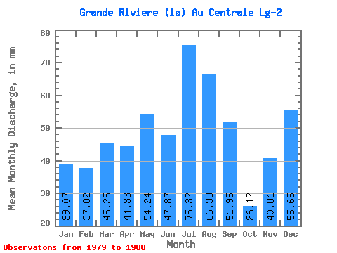
| Statistic | Jan | Feb | Mar | Apr | May | Jun | Jul | Aug | Sep | Oct | Nov | Dec | Annual |
|---|---|---|---|---|---|---|---|---|---|---|---|---|---|
| Mean | 39.06 | 38.15 | 45.24 | 44.33 | 54.23 | 47.87 | 75.31 | 66.32 | 51.95 | 26.12 | 40.81 | 55.64 | 616.52 |
| Standard Deviation | 23.47 | 23.06 | 0.80 | ||||||||||
| Min | 39.06 | 38.15 | 45.24 | 44.33 | 54.23 | 47.87 | 75.31 | 66.32 | 51.95 | 9.53 | 24.51 | 55.08 | 616.52 |
| Max | 39.06 | 38.15 | 45.24 | 44.33 | 54.23 | 47.87 | 75.31 | 66.32 | 51.95 | 42.71 | 57.12 | 56.20 | 616.52 |
| Coefficient of Variation | 0.90 | 0.56 | 0.01 |
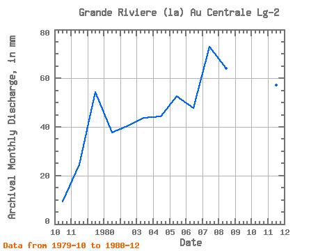
| Year | Jan | Feb | Mar | Apr | May | Jun | Jul | Aug | Sep | Oct | Nov | Dec | Annual | 1979 | 9.53 | 24.51 | 56.20 | 1980 | 39.06 | 38.15 | 45.24 | 44.33 | 54.23 | 47.87 | 75.31 | 66.32 | 51.95 | 42.71 | 57.12 | 55.08 | 616.52 |
|---|
 Return to R-Arctic Net Home Page