|
|
|||||||||||||||||
| Point ID: 5130 | Downloads | Plots | Site Data | Other Close Sites | Code: 03DE007 |
|
|
|||||||||||||||||
| Download | |
|---|---|
| Site Descriptor Information | Site Time Series Data |
| Link to all available data | |
|
|
| View: | Statistics | Time Series |
| Units: | m3/s |
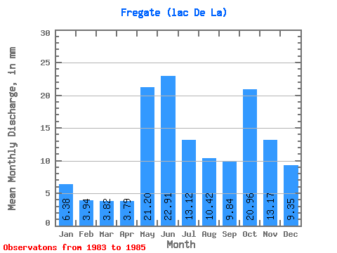
| Statistic | Jan | Feb | Mar | Apr | May | Jun | Jul | Aug | Sep | Oct | Nov | Dec | Annual |
|---|---|---|---|---|---|---|---|---|---|---|---|---|---|
| Mean | 6.38 | 3.98 | 3.82 | 3.79 | 21.20 | 22.91 | 13.12 | 10.42 | 9.84 | 20.96 | 13.17 | 9.35 | 145.77 |
| Standard Deviation | 0.92 | 0.62 | 0.38 | 0.40 | 10.91 | 1.21 | |||||||
| Min | 5.72 | 3.54 | 3.55 | 3.51 | 13.49 | 22.91 | 13.12 | 10.42 | 9.84 | 20.96 | 13.17 | 8.50 | 145.77 |
| Max | 7.03 | 4.42 | 4.09 | 4.08 | 28.91 | 22.91 | 13.12 | 10.42 | 9.84 | 20.96 | 13.17 | 10.21 | 145.77 |
| Coefficient of Variation | 0.14 | 0.16 | 0.10 | 0.10 | 0.52 | 0.13 |
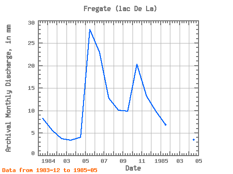
| Year | Jan | Feb | Mar | Apr | May | Jun | Jul | Aug | Sep | Oct | Nov | Dec | Annual | 1983 | 8.50 | 1984 | 5.72 | 3.54 | 3.55 | 4.08 | 28.91 | 22.91 | 13.12 | 10.42 | 9.84 | 20.96 | 13.17 | 10.21 | 145.77 | 1985 | 7.03 | 4.42 | 4.09 | 3.51 | 13.49 |
|---|
| Other Close Sites | ||||||
|---|---|---|---|---|---|---|
| PointID | Latitude | Longitude | Drainage Area | Source | Name | |
| 5121 | "MASTA (CHENAL) EN AVAL DE LA RIVIERE DE PONTOIS" | 53.25 | -1065352 | Hydat | ||
| 5122 | "DE PONTOIS (RIVIERE) EN AMONT DE LA RIVIERE SAKAMI" | 53.16 | -1078030 | Hydat | ||
| 5124 | "MASTA (CHENAL) EN AVAL DE LA RIVIERE DE PONTOIS-1" | 53.24 | -1064956 | Hydat | ||
| 5125 | "DE PONTOIS (RIVIERE) EN AVAL DE LA RIVIERE SAKAMI" | 53.28 | -1056405 | Hydat | ||
| 5128 | "SAKAMI (RIVIERE) EN AVAL DE LA RIVIERE DE PONTOIS-1" | 53.25 | -1053856 | Hydat | ||
| 5129 | "SAKAMI (RIVIERE) EN AVAL DE LA RIVIERE DE PONTOIS-2" | 53.25 | -1053856 | Hydat | ||
 Return to R-Arctic Net Home Page