|
|
|||||||||||||||||
| Point ID: 4415 | Downloads | Plots | Site Data | Code: 05PD031 |
|
|
|||||||||||||||||
| Download | |
|---|---|
| Site Descriptor Information | Site Time Series Data |
| Link to all available data | |
|
|
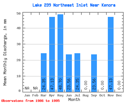
| View: | Statistics | Time Series |
| Units: | m3/s |
| Statistic | Jan | Feb | Mar | Apr | May | Jun | Jul | Aug | Sep | Oct | Nov | Dec | Annual |
|---|---|---|---|---|---|---|---|---|---|---|---|---|---|
| Mean | 24.34 | 56.55 | 46.26 | 18.85 | 24.34 | 7.30 | 30.63 | 4.87 | 47.13 | 0.00 | |||
| Standard Deviation | 47.39 | 29.15 | 21.65 | 28.11 | 16.43 | 43.09 | 10.27 | ||||||
| Min | 24.34 | 0.00 | 0.00 | 0.00 | 0.00 | 0.00 | 0.00 | 0.00 | 47.13 | 0.00 | |||
| Max | 24.34 | 141.38 | 97.38 | 47.13 | 73.04 | 48.69 | 117.82 | 24.34 | 47.13 | 0.00 | |||
| Coefficient of Variation | 0.84 | 0.63 | 1.15 | 1.16 | 2.25 | 1.41 | 2.11 |
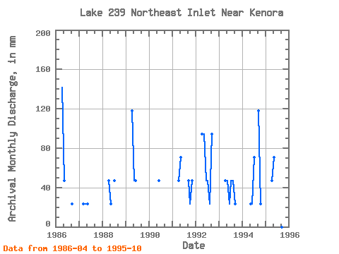
| Year | Jan | Feb | Mar | Apr | May | Jun | Jul | Aug | Sep | Oct | Nov | Dec | Annual | 1986 | 141.38 | 48.69 | 0.00 | 0.00 | 0.00 | 23.56 | 0.00 | 1987 | 24.34 | 23.56 | 24.34 | 0.00 | 0.00 | 0.00 | 0.00 | 0.00 | 1988 | 47.13 | 24.34 | 0.00 | 48.69 | 0.00 | 0.00 | 0.00 | 1989 | 117.82 | 48.69 | 47.13 | 0.00 | 0.00 | 0.00 | 0.00 | 1990 | 0.00 | 0.00 | 47.13 | 0.00 | 0.00 | 0.00 | 0.00 | 1991 | 47.13 | 73.04 | 0.00 | 0.00 | 0.00 | 47.13 | 24.34 | 47.13 | 0.00 | 1992 | 94.25 | 97.38 | 47.13 | 48.69 | 24.34 | 94.25 | 0.00 | 1993 | 47.13 | 48.69 | 23.56 | 48.69 | 48.69 | 23.56 | 0.00 | 1994 | 0.00 | 24.34 | 23.56 | 73.04 | 0.00 | 117.82 | 24.34 | 1995 | 47.13 | 73.04 | 0.00 | 24.34 | 0.00 | 0.00 | 0.00 |
|---|
 Return to R-Arctic Net Home Page