|
|
|||||||||||||||||
| Point ID: 42 | Downloads | Plots | Site Data | Code: 05AB024 |
|
|
|||||||||||||||||
| Download | |
|---|---|
| Site Descriptor Information | Site Time Series Data |
| Link to all available data | |
|
|
| View: | Statistics | Time Series |
| Units: | m3/s |
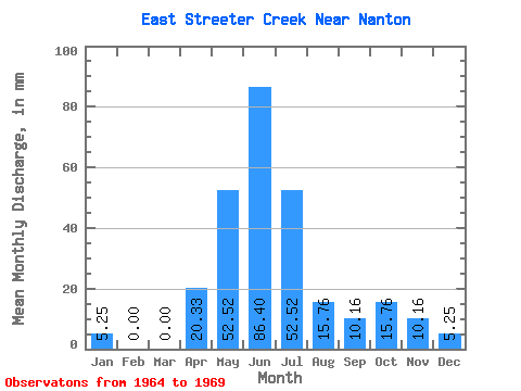
| Statistic | Jan | Feb | Mar | Apr | May | Jun | Jul | Aug | Sep | Oct | Nov | Dec | Annual |
|---|---|---|---|---|---|---|---|---|---|---|---|---|---|
| Mean | 2.62 | 1.59 | 0.88 | 18.64 | 52.51 | 83.86 | 52.51 | 14.88 | 9.32 | 15.75 | 10.16 | 6.13 | 268.16 |
| Standard Deviation | 4.39 | 2.47 | 2.14 | 26.64 | 37.43 | 50.49 | 42.92 | 6.14 | 5.00 | 18.49 | 10.16 | 6.14 | 88.90 |
| Min | 0.00 | 0.00 | 0.00 | 0.00 | 10.50 | 20.33 | 21.00 | 5.25 | 5.08 | 5.25 | 5.08 | 0.00 | 190.80 |
| Max | 10.50 | 4.78 | 5.25 | 71.15 | 105.02 | 157.55 | 131.28 | 21.00 | 15.25 | 52.51 | 30.49 | 15.75 | 422.86 |
| Coefficient of Variation | 1.67 | 1.55 | 2.45 | 1.43 | 0.71 | 0.60 | 0.82 | 0.41 | 0.54 | 1.17 | 1.00 | 1.00 | 0.33 |
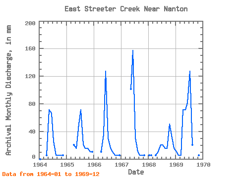
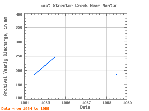
| Year | Jan | Feb | Mar | Apr | May | Jun | Jul | Aug | Sep | Oct | Nov | Dec | Annual | 1964 | 0.00 | 0.00 | 0.00 | 5.08 | 73.51 | 66.07 | 26.25 | 5.25 | 5.08 | 5.25 | 5.08 | 0.00 | 190.80 | 1965 | 0.00 | 0.00 | 0.00 | 20.33 | 15.75 | 50.82 | 73.51 | 21.00 | 15.25 | 15.75 | 10.16 | 10.50 | 232.06 | 1966 | 0.00 | 0.00 | 0.00 | 10.16 | 36.76 | 127.06 | 31.51 | 15.75 | 10.16 | 5.25 | 5.08 | 5.25 | 247.53 | 1967 | 0.00 | 0.00 | 0.00 | 0.00 | 105.02 | 157.55 | 31.51 | 10.50 | 5.08 | 5.25 | 5.08 | 0.00 | 319.73 | 1968 | 5.25 | 4.78 | 0.00 | 5.08 | 10.50 | 20.33 | 21.00 | 15.75 | 15.25 | 52.51 | 30.49 | 15.75 | 195.96 | 1969 | 10.50 | 4.78 | 5.25 | 71.15 | 73.51 | 81.32 | 131.28 | 21.00 | 5.08 | 10.50 | 5.08 | 5.25 | 422.86 |
|---|
 Return to R-Arctic Net Home Page