|
|
|||||||||||||||||
| Point ID: 41 | Downloads | Plots | Site Data | Code: 05AB023 |
|
|
|||||||||||||||||
| Download | |
|---|---|
| Site Descriptor Information | Site Time Series Data |
| Link to all available data | |
|
|
| View: | Statistics | Time Series |
| Units: | m3/s |
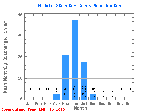
| Statistic | Jan | Feb | Mar | Apr | May | Jun | Jul | Aug | Sep | Oct | Nov | Dec | Annual |
|---|---|---|---|---|---|---|---|---|---|---|---|---|---|
| Mean | 0.00 | 0.00 | 0.00 | 4.27 | 19.62 | 36.08 | 16.68 | 1.47 | 0.47 | 0.49 | 0.47 | 0.00 | 79.48 |
| Standard Deviation | 0.00 | 0.00 | 0.00 | 10.47 | 29.64 | 32.51 | 24.46 | 2.46 | 1.16 | 1.20 | 1.16 | 0.00 | 81.92 |
| Min | 0.00 | 0.00 | 0.00 | 0.00 | 0.00 | 0.00 | 0.00 | 0.00 | 0.00 | 0.00 | 0.00 | 0.00 | 5.78 |
| Max | 0.00 | 0.00 | 0.00 | 25.64 | 73.57 | 76.91 | 64.74 | 5.89 | 2.85 | 2.94 | 2.85 | 0.00 | 202.31 |
| Coefficient of Variation | 2.45 | 1.51 | 0.90 | 1.47 | 1.67 | 2.45 | 2.45 | 2.45 | 1.03 |
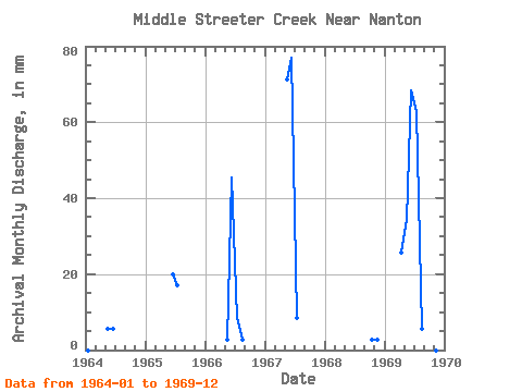
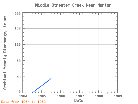
| Year | Jan | Feb | Mar | Apr | May | Jun | Jul | Aug | Sep | Oct | Nov | Dec | Annual | 1964 | 0.00 | 0.00 | 0.00 | 0.00 | 5.89 | 5.70 | 0.00 | 0.00 | 0.00 | 0.00 | 0.00 | 0.00 | 11.56 | 1965 | 0.00 | 0.00 | 0.00 | 0.00 | 0.00 | 19.94 | 17.66 | 0.00 | 0.00 | 0.00 | 0.00 | 0.00 | 37.57 | 1966 | 0.00 | 0.00 | 0.00 | 0.00 | 2.94 | 45.57 | 8.83 | 2.94 | 0.00 | 0.00 | 0.00 | 0.00 | 60.69 | 1967 | 0.00 | 0.00 | 0.00 | 0.00 | 73.57 | 76.91 | 8.83 | 0.00 | 0.00 | 0.00 | 0.00 | 0.00 | 158.96 | 1968 | 0.00 | 0.00 | 0.00 | 0.00 | 0.00 | 0.00 | 0.00 | 0.00 | 0.00 | 2.94 | 2.85 | 0.00 | 5.78 | 1969 | 0.00 | 0.00 | 0.00 | 25.64 | 35.31 | 68.36 | 64.74 | 5.89 | 2.85 | 0.00 | 0.00 | 0.00 | 202.31 |
|---|
 Return to R-Arctic Net Home Page