|
|
|||||||||||||||||
| Point ID: 3572 | Downloads | Plots | Site Data | Code: 07QD005 |
|
|
|||||||||||||||||
| Download | |
|---|---|
| Site Descriptor Information | Site Time Series Data |
| Link to all available data | |
|
|
| View: | Statistics | Time Series |
| Units: | m3/s |
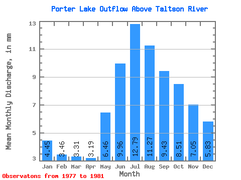
| Statistic | Jan | Feb | Mar | Apr | May | Jun | Jul | Aug | Sep | Oct | Nov | Dec | Annual |
|---|---|---|---|---|---|---|---|---|---|---|---|---|---|
| Mean | 4.45 | 3.49 | 3.31 | 3.19 | 6.46 | 9.96 | 12.79 | 11.27 | 9.43 | 8.51 | 7.05 | 5.83 | 89.42 |
| Standard Deviation | 0.48 | 0.34 | 0.29 | 0.48 | 1.15 | 3.37 | 6.03 | 6.37 | 4.64 | 3.32 | 1.81 | 1.12 | 33.41 |
| Min | 4.12 | 3.26 | 3.12 | 2.83 | 5.64 | 6.10 | 5.72 | 4.93 | 5.13 | 6.25 | 5.35 | 5.12 | 61.00 |
| Max | 5.00 | 3.87 | 3.64 | 3.74 | 7.77 | 12.34 | 21.45 | 21.58 | 17.36 | 14.04 | 9.90 | 7.49 | 126.23 |
| Coefficient of Variation | 0.11 | 0.10 | 0.09 | 0.15 | 0.18 | 0.34 | 0.47 | 0.56 | 0.49 | 0.39 | 0.26 | 0.19 | 0.37 |
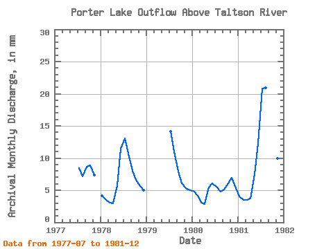
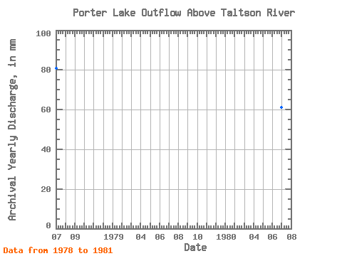
| Year | Jan | Feb | Mar | Apr | May | Jun | Jul | Aug | Sep | Oct | Nov | Dec | Annual | 1977 | 8.71 | 7.33 | 8.68 | 9.19 | 7.41 | 1978 | 4.22 | 3.26 | 3.16 | 3.00 | 5.97 | 11.43 | 13.52 | 11.10 | 8.05 | 6.81 | 5.64 | 5.12 | 81.05 | 1979 | 14.56 | 11.39 | 7.94 | 6.27 | 5.35 | 5.21 | 1980 | 5.00 | 3.87 | 3.12 | 2.83 | 5.64 | 6.10 | 5.72 | 4.93 | 5.13 | 6.25 | 6.93 | 5.50 | 61.00 | 1981 | 4.12 | 3.33 | 3.64 | 3.74 | 7.77 | 12.34 | 21.45 | 21.58 | 17.36 | 14.04 | 9.90 | 7.49 | 126.23 |
|---|
 Return to R-Arctic Net Home Page