|
|
|||||||||||||||||
| Point ID: 3549 | Downloads | Plots | Site Data | Code: 06OA004 |
|
|
|||||||||||||||||
| Download | |
|---|---|
| Site Descriptor Information | Site Time Series Data |
| Link to all available data | |
|
|
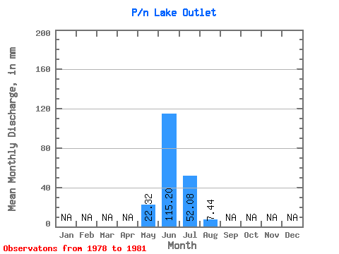
| View: | Statistics | Time Series |
| Units: | m3/s |
| Statistic | Jan | Feb | Mar | Apr | May | Jun | Jul | Aug | Sep | Oct | Nov | Dec | Annual |
|---|---|---|---|---|---|---|---|---|---|---|---|---|---|
| Mean | 22.32 | 111.60 | 53.93 | 9.30 | |||||||||
| Standard Deviation | 31.56 | 41.78 | 53.43 | 18.60 | |||||||||
| Min | 0.00 | 72.00 | 0.00 | 0.00 | |||||||||
| Max | 44.63 | 165.60 | 119.02 | 37.19 | |||||||||
| Coefficient of Variation | 1.41 | 0.37 | 0.99 | 2.00 |
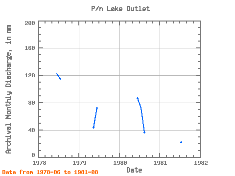
| Year | Jan | Feb | Mar | Apr | May | Jun | Jul | Aug | Sep | Oct | Nov | Dec | Annual | 1978 | 122.40 | 119.02 | 0.00 | 1979 | 44.63 | 72.00 | 0.00 | 0.00 | 1980 | 0.00 | 86.40 | 74.39 | 37.19 | 1981 | 165.60 | 22.32 | 0.00 |
|---|
 Return to R-Arctic Net Home Page