|
|
|||||||||||||||||
| Point ID: 3547 | Downloads | Plots | Site Data | Code: 06OA002 |
|
|
|||||||||||||||||
| Download | |
|---|---|
| Site Descriptor Information | Site Time Series Data |
| Link to all available data | |
|
|
| View: | Statistics | Time Series |
| Units: | m3/s |
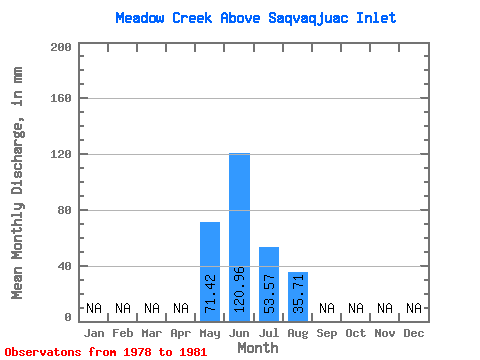
| Statistic | Jan | Feb | Mar | Apr | May | Jun | Jul | Aug | Sep | Oct | Nov | Dec | Annual |
|---|---|---|---|---|---|---|---|---|---|---|---|---|---|
| Mean | 71.41 | 129.60 | 58.02 | 26.78 | |||||||||
| Standard Deviation | 50.50 | 49.88 | 57.16 | 30.92 | |||||||||
| Min | 35.71 | 86.40 | 0.00 | 0.00 | |||||||||
| Max | 107.12 | 172.80 | 107.12 | 71.41 | |||||||||
| Coefficient of Variation | 0.71 | 0.39 | 0.98 | 1.16 |
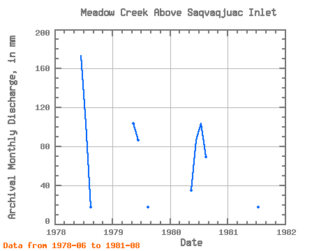
| Year | Jan | Feb | Mar | Apr | May | Jun | Jul | Aug | Sep | Oct | Nov | Dec | Annual | 1978 | 172.80 | 107.12 | 17.85 | 1979 | 107.12 | 86.40 | 0.00 | 17.85 | 1980 | 35.71 | 86.40 | 107.12 | 71.41 | 1981 | 172.80 | 17.85 | 0.00 |
|---|
 Return to R-Arctic Net Home Page