|
|
|||||||||||||||||
| Point ID: 3070 | Downloads | Plots | Site Data | Code: 05PF067 |
|
|
|||||||||||||||||
| Download | |
|---|---|
| Site Descriptor Information | Site Time Series Data |
| Link to all available data | |
|
|
| View: | Statistics | Time Series |
| Units: | m3/s |
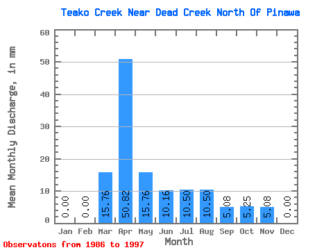
| Statistic | Jan | Feb | Mar | Apr | May | Jun | Jul | Aug | Sep | Oct | Nov | Dec | Annual |
|---|---|---|---|---|---|---|---|---|---|---|---|---|---|
| Mean | 0.00 | 0.00 | 13.56 | 48.71 | 17.18 | 12.01 | 9.07 | 10.03 | 2.77 | 3.82 | 4.16 | 0.48 | 115.33 |
| Standard Deviation | 0.00 | 0.00 | 18.11 | 37.56 | 9.71 | 20.99 | 15.77 | 23.77 | 6.17 | 6.25 | 7.81 | 1.58 | 49.05 |
| Min | 0.00 | 0.00 | 0.00 | 10.16 | 0.00 | 0.00 | 0.00 | 0.00 | 0.00 | 0.00 | 0.00 | 0.00 | 36.10 |
| Max | 0.00 | 0.00 | 52.51 | 132.14 | 31.51 | 71.15 | 47.26 | 73.51 | 20.33 | 15.75 | 25.41 | 5.25 | 190.80 |
| Coefficient of Variation | 1.33 | 0.77 | 0.56 | 1.75 | 1.74 | 2.37 | 2.23 | 1.64 | 1.88 | 3.32 | 0.42 |
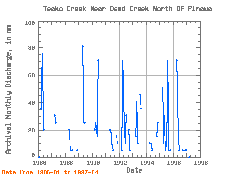
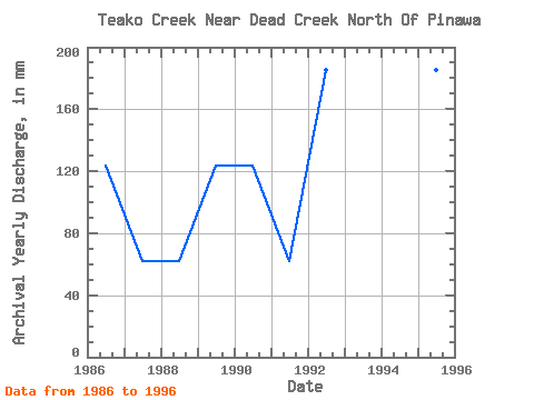
| Year | Jan | Feb | Mar | Apr | May | Jun | Jul | Aug | Sep | Oct | Nov | Dec | Annual | 1986 | 0.00 | 0.00 | 36.76 | 76.23 | 21.00 | 0.00 | 0.00 | 0.00 | 0.00 | 0.00 | 0.00 | 0.00 | 134.08 | 1987 | 0.00 | 0.00 | 31.51 | 25.41 | 0.00 | 0.00 | 0.00 | 0.00 | 0.00 | 0.00 | 0.00 | 0.00 | 56.73 | 1988 | 0.00 | 0.00 | 0.00 | 20.33 | 5.25 | 0.00 | 5.25 | 0.00 | 0.00 | 0.00 | 5.08 | 0.00 | 36.10 | 1989 | 0.00 | 0.00 | 0.00 | 81.32 | 26.25 | 25.41 | 0.00 | 0.00 | 0.00 | 0.00 | 0.00 | 0.00 | 134.08 | 1990 | 0.00 | 0.00 | 21.00 | 25.41 | 15.75 | 71.15 | 0.00 | 0.00 | 0.00 | 0.00 | 0.00 | 0.00 | 134.08 | 1991 | 0.00 | 0.00 | 0.00 | 20.33 | 21.00 | 10.16 | 5.25 | 0.00 | 0.00 | 15.75 | 10.16 | 0.00 | 82.51 | 1992 | 0.00 | 0.00 | 5.25 | 71.15 | 26.25 | 10.16 | 31.51 | 0.00 | 20.33 | 5.25 | 0.00 | 0.00 | 170.18 | 1993 | 0.00 | 0.00 | 15.75 | 40.66 | 10.50 | 0.00 | 47.26 | 36.76 | 0.00 | 0.00 | 0.00 | 0.00 | 149.55 | 1994 | 0.00 | 0.00 | 0.00 | 10.16 | 10.50 | 5.08 | 0.00 | 0.00 | 0.00 | 15.75 | 25.41 | 0.00 | 67.04 | 1995 | 0.00 | 0.00 | 52.51 | 10.16 | 31.51 | 5.08 | 10.50 | 73.51 | 5.08 | 5.25 | 0.00 | 0.00 | 190.80 | 1996 | 0.00 | 0.00 | 0.00 | 71.15 | 21.00 | 5.08 | 0.00 | 0.00 | 5.08 | 0.00 | 5.08 | 5.25 | 113.45 | 1997 | 0.00 | 0.00 | 0.00 | 132.14 |
|---|
 Return to R-Arctic Net Home Page