|
|
|||||||||||||||||
| Point ID: 3069 | Downloads | Plots | Site Data | Code: 05PF066 |
|
|
|||||||||||||||||
| Download | |
|---|---|
| Site Descriptor Information | Site Time Series Data |
| Link to all available data | |
|
|
| View: | Statistics | Time Series |
| Units: | m3/s |
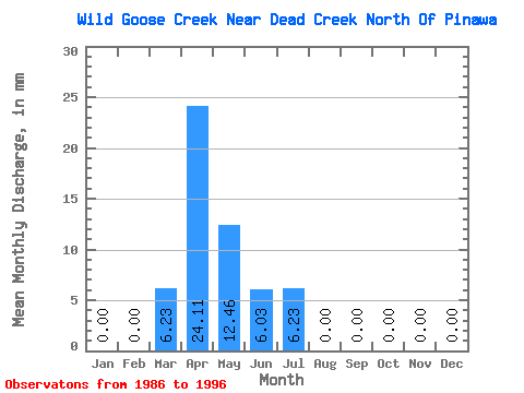
| Statistic | Jan | Feb | Mar | Apr | May | Jun | Jul | Aug | Sep | Oct | Nov | Dec | Annual |
|---|---|---|---|---|---|---|---|---|---|---|---|---|---|
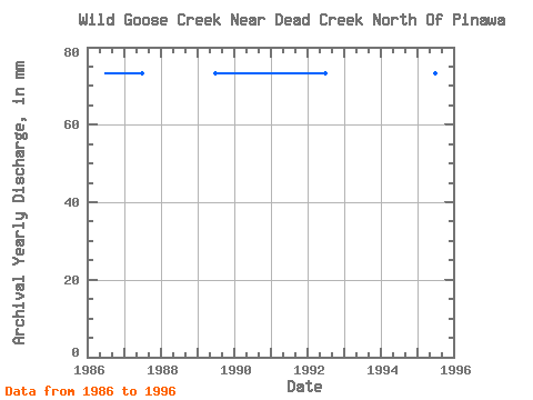
| Mean | 0.00 | 0.00 | 7.36 | 24.66 | 14.15 | 8.22 | 5.10 | 2.27 | 1.10 | 1.70 | 1.64 | 0.00 | 66.17 |
| Standard Deviation | 0.00 | 0.00 | 10.35 | 18.37 | 13.67 | 18.14 | 8.73 | 5.04 | 3.63 | 4.03 | 3.90 | 0.00 | 23.82 |
| Min | 0.00 | 0.00 | 0.00 | 0.00 | 0.00 | 0.00 | 0.00 | 0.00 | 0.00 | 0.00 | 0.00 | 0.00 | 30.58 |
| Max | 0.00 | 0.00 | 31.14 | 60.28 | 49.82 | 60.28 | 24.91 | 12.46 | 12.06 | 12.46 | 12.06 | 0.00 | 103.98 |
| Coefficient of Variation | 1.41 | 0.74 | 0.97 | 2.21 | 1.71 | 2.23 | 3.32 | 2.37 | 2.37 | 0.36 |
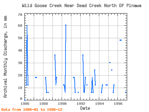
| Year | Jan | Feb | Mar | Apr | May | Jun | Jul | Aug | Sep | Oct | Nov | Dec | Annual | 1986 | 0.00 | 0.00 | 12.46 | 60.28 | 12.46 | 0.00 | 0.00 | 0.00 | 0.00 | 0.00 | 0.00 | 0.00 | 85.63 | 1987 | 0.00 | 0.00 | 18.68 | 18.08 | 0.00 | 0.00 | 0.00 | 0.00 | 0.00 | 0.00 | 0.00 | 0.00 | 36.70 | 1988 | 0.00 | 0.00 | 0.00 | 18.08 | 6.23 | 0.00 | 6.23 | 0.00 | 0.00 | 0.00 | 0.00 | 0.00 | 30.58 | 1989 | 0.00 | 0.00 | 0.00 | 36.17 | 12.46 | 18.08 | 0.00 | 0.00 | 0.00 | 0.00 | 0.00 | 0.00 | 67.28 | 1990 | 0.00 | 0.00 | 12.46 | 12.06 | 6.23 | 60.28 | 0.00 | 0.00 | 0.00 | 0.00 | 0.00 | 0.00 | 91.74 | 1991 | 0.00 | 0.00 | 0.00 | 18.08 | 18.68 | 6.03 | 0.00 | 0.00 | 0.00 | 6.23 | 0.00 | 0.00 | 48.93 | 1992 | 0.00 | 0.00 | 0.00 | 36.17 | 6.23 | 6.03 | 18.68 | 0.00 | 12.06 | 0.00 | 0.00 | 0.00 | 79.51 | 1993 | 0.00 | 0.00 | 6.23 | 18.08 | 6.23 | 0.00 | 24.91 | 12.46 | 0.00 | 0.00 | 0.00 | 0.00 | 67.28 | 1994 | 0.00 | 0.00 | 0.00 | 6.03 | 12.46 | 0.00 | 0.00 | 0.00 | 0.00 | 12.46 | 12.06 | 0.00 | 42.81 | 1995 | 0.00 | 0.00 | 31.14 | 0.00 | 24.91 | 0.00 | 6.23 | 12.46 | 0.00 | 0.00 | 0.00 | 0.00 | 73.39 | 1996 | 0.00 | 0.00 | 0.00 | 48.22 | 49.82 | 0.00 | 0.00 | 0.00 | 0.00 | 0.00 | 6.03 | 0.00 | 103.98 |
|---|
 Return to R-Arctic Net Home Page